FAA INFORMATION EFFECTIVE 30 OCTOBER 2025
Location
| FAA Identifier: | MOT |
| Lat/Long: | 48-15-27.5000N 101-16-40.9000W
48-15.458333N 101-16.681667W
48.2576389,-101.2780278
(estimated) |
| Elevation: | 1715.7 ft. / 522.9 m (surveyed) |
| Variation: | 06E (2020) |
| From city: | 2 miles N of MINOT, ND |
| Time zone: | UTC -6 (UTC -5 during Daylight Saving Time) |
| Zip code: | 58703 |
Airport Operations
| Airport use: | Open to the public |
| Activation date: | 03/1940 |
| Control tower: | yes |
| ARTCC: | MINNEAPOLIS CENTER |
| FSS: | GRAND FORKS FLIGHT SERVICE STATION |
| NOTAMs facility: | MOT (NOTAM-D service available) |
| Attendance: | CONTINUOUS |
| Wind indicator: | lighted |
| Segmented circle: | yes |
| Lights: | WHEN ATCT IS CLSD, ACTVT MALSR RWY 31; REIL RWYS 08 & 26; HIRL RWYS 08/26 & 13/31 - CTAF. PAPI RWYS 08, 13, & 26 OPR CONSLY. |
| Beacon: | white-green (lighted land airport)
Operates sunset to sunrise. |
| Landing fee: | yes, LDG FEE FOR ALL COML FREIGHT AND COMMUTER ACFT AND ALL ACFT OVR 12500 LB. |
| Fire and rescue: | ARFF index B |
| International operations: | international airport of entry |
Airport Communications
| CTAF: | 118.2 |
| UNICOM: | 122.95 |
| WX ASOS: | 118.725 (701-837-9379) |
| MAGIC CITY GROUND: | 121.9 [0700-2200] |
| MAGIC CITY TOWER: | 118.2 251.125 [0700-2200] |
| MINOT APPROACH: | 119.6 |
| MINOT DEPARTURE: | 119.6 |
- APCH/DEP SVC PRVDD BY MINNEAPOLIS ARTCC ON FREQS 127.6/279.6 (MINOT RCAG) WHEN MINOT APCH CTL CLSD.
Nearby radio navigation aids
| VOR radial/distance | | VOR name | | Freq | | Var |
|---|
| MOT at field | | MINOT VOR/DME | | 117.10 | | 13E |
Airport Services
| Fuel available: | 100LL JET-A |
| Parking: | tiedowns |
| Airframe service: | MAJOR |
| Powerplant service: | MAJOR |
| Bottled oxygen: | HIGH |
Runway Information
Runway 13/31
| Dimensions: | 7700 x 150 ft. / 2347 x 46 m |
| Surface: | concrete/grooved, in good condition |
| Weight bearing capacity: | | Single wheel: | 120.0 | | Double wheel: | 162.0 | | Double tandem: | 262.0 |
|
| Runway edge lights: | high intensity |
| RUNWAY 13 | | RUNWAY 31 |
| Latitude: | 48-15.914990N | | 48-14.968132N |
| Longitude: | 101-17.324363W | | 101-16.065112W |
| Elevation: | 1701.8 ft. | | 1657.1 ft. |
| Traffic pattern: | left | | left |
| Runway heading: | 132 magnetic, 138 true | | 312 magnetic, 318 true |
| Declared distances: | TORA:7700 TODA:7700 ASDA:7700 LDA:7700 | | TORA:7700 TODA:7700 ASDA:7700 LDA:7700 |
| Markings: | precision, in good condition | | precision, in good condition |
| Visual slope indicator: | 4-light PAPI on left (3.00 degrees glide path) | | |
| RVR equipment: | rollout | | touchdown |
| Approach lights: | | | MALSR: 1,400 foot medium intensity approach lighting system with runway alignment indicator lights |
| Runway end identifier lights: | yes | | no |
| Touchdown point: | yes, no lights | | yes, no lights |
| Instrument approach: | | | ILS/DME |
Runway 8/26
| Dimensions: | 6348 x 100 ft. / 1935 x 30 m |
| Surface: | asphalt/grooved, in fair condition |
| Weight bearing capacity: | | Single wheel: | 81.0 | | Double wheel: | 118.0 | | Double tandem: | 186.0 |
|
| Runway edge lights: | high intensity |
| RUNWAY 8 | | RUNWAY 26 |
| Latitude: | 48-15.482588N | | 48-15.478020N |
| Longitude: | 101-17.446945W | | 101-15.883657W |
| Elevation: | 1715.7 ft. | | 1658.2 ft. |
| Traffic pattern: | left | | left |
| Runway heading: | 084 magnetic, 090 true | | 264 magnetic, 270 true |
| Displaced threshold: | 393 ft. | | no |
| Declared distances: | TORA:6348 TODA:6348 ASDA:6348 LDA:5958 | | TORA:5958 TODA:5958 ASDA:6348 LDA:6348 |
| Markings: | nonprecision, in good condition | | nonprecision, in good condition |
| Visual slope indicator: | 4-light PAPI on left (3.00 degrees glide path) | | 4-light PAPI on left (3.00 degrees glide path) |
| Runway end identifier lights: | yes | | yes |
| Touchdown point: | yes, no lights | | yes, no lights |
| Obstructions: | 57 ft. trees, 1900 ft. from runway, 160 ft. left of centerline, 29:1 slope to clear
RWY 08 APCH RATIO 24:1 FM DTHR. | | none |
Airport Ownership and Management from official FAA records
| Ownership: | Publicly-owned |
| Owner: | CITY OF MINOT
305 AIRPORT RD., SUITE 216
MINOT, ND 58703
Phone 701-857-4724 |
| Manager: | JENNIFER ECKMAN
305 AIRPORT RD, SUITE 216
MINOT, ND 58703
Phone 701-857-4724 |
Additional Remarks
| A39-13/31 | PCR VALUE: 500/R/C/W/T |
| A39-08/26 | PCR VALUE: 320/F/C/X/T |
| - | DEER & BIRDS INVOF ARPT. |
| - | AIRFIELD STD TFC PATTERN ALT 1000 FT; OVERFLY ALT 1500 FT. |
| - | WHEN ATCT CLSD CTC - CTAF. |
| - | TWYS E, B2, F, AND A ARE MKD WITH EDGE REFLECTORS. |
| - | CUSTOMS SVC AVBL 24 HRS; FOR CUSTOMS CALL 701-838-6704. |
| - | MINOT AFB (MIB) ASR OTS FOR PREVENTIVE MAINTENANCE FRIDAYS 0700-0900 & ALTN TUESDAYS 0630-0830. |
| - | RDO EQUIPD ACFT MUST ANNC ON CTAF - 118.2 WHEN TWR IS CLSD. |
| - | FOR CD IF UNA TO CTC ON FSS FREQ, CTC MINNEAPOLIS ARTCC AT 651-463-5588. |
Instrument Procedures
NOTE: All procedures below are presented as PDF files. If you need a reader for these files, you should download the free Adobe Reader.NOT FOR NAVIGATION. Please procure official charts for flight.
FAA instrument procedures published for use from 30 October 2025 at 0901Z to 27 November 2025 at 0900Z.
IAPs - Instrument Approach Procedures |
|---|
| ILS OR LOC RWY 31 | |
download (256KB) |
| RNAV (GPS) RWY 08 | |
download (238KB) |
| RNAV (GPS) RWY 13 | |
download (216KB) |
| RNAV (GPS) RWY 26 | |
download (208KB) |
| RNAV (GPS) RWY 31 | |
download (222KB) |
| LOC BC RWY 13 | |
download (203KB) |
| VOR RWY 08 | |
download (196KB) |
| VOR RWY 13 | |
download (154KB) |
| VOR RWY 26 | |
download (195KB) |
| VOR RWY 31 | |
download (151KB) |
| NOTE: Special Alternate Minimums apply | |
download (152KB) |
| NOTE: Special Take-Off Minimums/Departure Procedures apply **CHANGED** | |
download (420KB) |
Other nearby airports with instrument procedures:
KMIB - Minot Air Force Base (10 nm N)
KHBC - Mohall Municipal Airport (32 nm N)
D05 - Garrison Municipal Airport (37 nm S)
7K5 - Kenmare Municipal Airport (39 nm NW)
08D - Stanley Municipal Airport (45 nm W)
|
|

Road maps at:
MapQuest
Bing
Google
| Aerial photo |
|---|
WARNING: Photo may not be current or correct

Do you have a better or more recent aerial photo of Minot International Airport that you would like to share? If so, please send us your photo.
|
| Sectional chart |
|---|
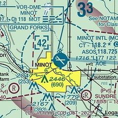
|
CAUTION: Diagram may not be current
 Download PDF
of official airport diagram from the FAA
| Airport distance calculator |
|---|
|
|
| Sunrise and sunset |
|---|
|
Times for 07-Nov-2025
| | Local
(UTC-6) | | Zulu
(UTC) |
|---|
| Morning civil twilight | | 07:08 | | 13:08 |
| Sunrise | | 07:41 | | 13:41 |
| Sunset | | 17:17 | | 23:17 |
| Evening civil twilight | | 17:50 | | 23:50 |
|
| Current date and time |
|---|
| Zulu (UTC) | 07-Nov-2025 08:47:04 |
|---|
| Local (UTC-6) | 07-Nov-2025 02:47:04 |
|---|
|
| METAR |
|---|
| KMOT | 070837Z AUTO 35013KT 5SM -SN BR OVC005 01/M01 A2970 RMK AO2 P0000 T00061006
|
KMIB
10nm N | 070755Z 03012KT 7SM -DZ OVC005 01/M00 A2965 RMK AO2A SNB10E55DZB55 SLP055 P0000 T00081004
|
|
| TAF |
|---|
| KMOT | 070730Z 0708/0806 33015G25KT P6SM OVC004 FM071300 01009KT P6SM OVC007 FM071600 04008KT P6SM OVC012 FM080000 11007KT 4SM -SN BR OVC015
|
KMIB
10nm N | 070717Z 0707/0807 01010G15KT 6000 -SN BKN004 OVC010 630049 QNH2949INS BECMG 0715/0716 03010G20KT 9999 NSW BKN010 620109 QNH2983INS BECMG 0716/0717 03010G15KT 9999 BKN020 620208 QNH2983INS BECMG 0800/0801 10009KT 8000 -SN OVC020 630208 QNH2975INS TEMPO 0801/0807 4800 -SN OVC010 630109 TX01/0719Z TNM02/0713Z
|
|
| NOTAMs |
|---|
NOTAMs are issued by the DoD/FAA and will open in a separate window not controlled by AirNav.
|
|


