FAA INFORMATION EFFECTIVE 16 APRIL 2026
Location
| FAA Identifier: | MPE |
| Lat/Long: | 32-47-57.1633N 089-07-33.5899W
32-47.952722N 089-07.559832W
32.7992120,-89.1259972
(estimated) |
| Elevation: | 458.2 ft. / 139.7 m (surveyed) |
| Variation: | 01E (1990) |
| From city: | 2 miles NW of PHILADELPHIA, MS |
| Time zone: | UTC -5 (UTC -6 during Standard Time) |
| Zip code: | 39350 |
Airport Operations
| Airport use: | Open to the public |
| Control tower: | no |
| ARTCC: | MEMPHIS CENTER |
| FSS: | GREENWOOD FLIGHT SERVICE STATION |
| NOTAMs facility: | GWO (NOTAM-D service available) |
| Attendance: | MON-SUN 0700-1700
AFT HRS SVC MON-WED CALL 769-236-8154, THU-SUN CALL 818-916-4845. |
| Wind indicator: | lighted |
| Segmented circle: | yes |
| Lights: | ACTVT REIL RWY 18 & 36; PAPI RWY 18 & 36; MIRL 18/36 - CTAF. |
| Beacon: | white-green (lighted land airport)
Operates sunset to sunrise. |
Airport Communications
| CTAF/UNICOM: | 123.0 |
| WX AWOS-3P: | 118.725 (601-663-0040) |
- APCH/DEP SVC PRVDD BY MEMPHIS ARTCC ON FREQS 132.75/263.0 (LOUISVILLE RCAG).
Nearby radio navigation aids
| VOR radial/distance | | VOR name | | Freq | | Var |
|---|
| MEIr322/30.0 | | MERIDIAN VORTAC | | 117.00 | | 05E |
Airport Services
| Fuel available: | 100LL JET-A
A:NO CREDIT CARD SELF SVC AVBL. |
| Parking: | tiedowns |
Runway Information
Runway 18/36
| Dimensions: | 5001 x 75 ft. / 1524 x 23 m |
| Surface: | asphalt, in good condition |
| Weight bearing capacity: | |
| Runway edge lights: | medium intensity |
| RUNWAY 18 | | RUNWAY 36 |
| Latitude: | 32-48.362952N | | 32-47.542492N |
| Longitude: | 089-07.510518W | | 089-07.609145W |
| Elevation: | 440.4 ft. | | 458.1 ft. |
| Traffic pattern: | left | | left |
| Runway heading: | 184 magnetic, 185 true | | 004 magnetic, 005 true |
| Markings: | nonprecision, in good condition | | nonprecision, in good condition |
| Visual slope indicator: | 2-light PAPI on left (3.00 degrees glide path) | | 2-light PAPI on left (3.00 degrees glide path)
PAPI UNUSBL BYD 7 DEGS LEFT OF CNTRLN. |
| Runway end identifier lights: | yes | | yes |
| Touchdown point: | yes, no lights | | yes, no lights |
| Obstructions: | 75 ft. trees, 1550 ft. from runway, 18:1 slope to clear | | 68 ft. trees, 1575 ft. from runway, 250 ft. right of centerline, 20:1 slope to clear |
Airport Ownership and Management from official FAA records
| Ownership: | Publicly-owned |
| Owner: | CITY OF PHILADELPHIA
525 MAIN ST
PHILADELPHIA, MS 39350
Phone 601-656-3612 |
| Manager: | DAN CUMBERLAND
1036 AIRPORT RD
PHILADELPHIA, MS 39350
Phone 601-656-0203 |
Additional Remarks
| - | FOR CD CTC MEMPHIS ARTCC AT 901-368-8453/8449. |
Instrument Procedures
NOTE: All procedures below are presented as PDF files. If you need a reader for these files, you should download the free Adobe Reader.NOT FOR NAVIGATION. Please procure official charts for flight.
FAA instrument procedures published for use from 16 April 2026 at 0901Z to 14 May 2026 at 0900Z.
IAPs - Instrument Approach Procedures |
|---|
| RNAV (GPS) RWY 18 | |
download (245KB) |
| RNAV (GPS) RWY 36 | |
download (250KB) |
| NOTE: Special Alternate Minimums apply | |
download (159KB) |
| NOTE: Special Take-Off Minimums/Departure Procedures apply | |
download (116KB) |
Other nearby airports with instrument procedures:
KNJW - Joe Williams Naval Outlying Field (15 nm E)
KLMS - Louisville/Winston County Airport (21 nm N)
KOSX - Kosciusko-Attala County Airport (27 nm NW)
KNMM - Meridian Naval Air Station (Mc Cain Field) Airport (32 nm SE)
KMEI - Key Field Airport (34 nm SE)
|
|

Road maps at:
MapQuest
Bing
Google
| Aerial photo |
|---|
WARNING: Photo may not be current or correct
 Photo taken 16-Dec-2005
Do you have a better or more recent aerial photo of Philadelphia Municipal Airport that you would like to share? If so, please send us your photo.
|
| Sectional chart |
|---|
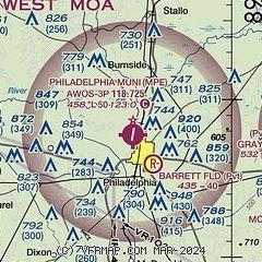
|
| Airport distance calculator |
|---|
|
|
| Sunrise and sunset |
|---|
|
Times for 21-Apr-2026
| | Local
(UTC-5) | | Zulu
(UTC) |
|---|
| Morning civil twilight | | 05:55 | | 10:55 |
| Sunrise | | 06:21 | | 11:21 |
| Sunset | | 19:30 | | 00:30 |
| Evening civil twilight | | 19:55 | | 00:55 |
|
| Current date and time |
|---|
| Zulu (UTC) | 21-Apr-2026 09:54:18 |
|---|
| Local (UTC-5) | 21-Apr-2026 04:54:18 |
|---|
|
| METAR |
|---|
| KMPE | 210935Z AUTO 00000KT 7SM OVC042 07/07 A3026 RMK AO2
|
KNJW
15nm E | 210857Z AUTO 00000KT 10SM CLR 07/06 A3030 RMK AO2 SLP174 T00670061 56005 $
|
|
| TAF |
|---|
KNMM
32nm SE | 210700Z 2107/2207 VRB04KT 9999 BKN250 QNH3024INS FM211800 14006KT 9999 BKN250 QNH3019INS BECMG 2203/2205 VRB05KT 9999 FEW100 BKN250 AUTOMATED SENSOR METWATCH 2107 TIL 2111 TX28/2121Z TN08/2111Z FN00324
|
KMEI
34nm SE | 210542Z 2106/2206 07008KT P6SM SCT250
|
|
| NOTAMs |
|---|
NOTAMs are issued by the DoD/FAA and will open in a separate window not controlled by AirNav.
|
|

