FAA INFORMATION EFFECTIVE 16 APRIL 2026
Location
| FAA Identifier: | MRC |
| Lat/Long: | 35-33-15.6190N 087-10-44.9040W
35-33.260317N 087-10.748400W
35.5543386,-87.1791400
(estimated) |
| Elevation: | 681.3 ft. / 207.7 m (surveyed) |
| Variation: | 01W (1990) |
| From city: | 2 miles NE of central business district of the associated city |
| Time zone: | UTC -5 (UTC -6 during Standard Time) |
| Zip code: | 38474 |
Airport Operations
| Airport use: | Open to the public |
| Activation date: | 11/1962 |
| Control tower: | no |
| ARTCC: | MEMPHIS CENTER |
| FSS: | JACKSON FLIGHT SERVICE STATION |
| NOTAMs facility: | MKL (NOTAM-D service available) |
| Attendance: | 0700-1700
CLSD THANKSGIVING & CHRISTMAS. |
| Wind indicator: | lighted |
| Segmented circle: | yes |
| Lights: | ACTVT ODALS RWY 24; REIL RWY 24 - CTAF. |
| Beacon: | white-green (lighted land airport)
Operates sunset to sunrise. |
Airport Communications
| CTAF/UNICOM: | 122.8 |
| WX AWOS-3: | 128.625 (931-379-0844) |
| WX AWOS-3 at LUG (19 nm E): | 135.775 (931-270-1014) |
| WX AWOS-3 at 2M2 (20 nm S): | 120.175 (931-766-1585) |
- APCH/DEP SVC PRVDD BY MEMPHIS ARTCC ON FREQS 125.85/379.25 (CENTERVILLE RCAG).
Nearby radio navigation aids
| VOR radial/distance | | VOR name | | Freq | | Var |
|---|
| SYIr270/36.1 | | SHELBYVILLE VOR/DME | | 113.55 | | 01W |
Airport Services
| Fuel available: | 100LL JET-A+ |
| Parking: | hangars and tiedowns |
| Airframe service: | MINOR |
| Powerplant service: | MINOR |
Runway Information
Runway 6/24
| Dimensions: | 6000 x 100 ft. / 1829 x 30 m |
| Surface: | asphalt, in good condition |
| Weight bearing capacity: | | PCN 12 /F/C/X/T | | Single wheel: | 33.5 | | Double wheel: | 50.0 | | Double tandem: | 70.0 |
|
| Runway edge lights: | medium intensity |
| RUNWAY 6 | | RUNWAY 24 |
| Latitude: | 35-33.018515N | | 35-33.603892N |
| Longitude: | 087-11.227910W | | 087-10.252603W |
| Elevation: | 664.0 ft. | | 681.1 ft. |
| Traffic pattern: | left | | left |
| Runway heading: | 055 magnetic, 054 true | | 235 magnetic, 234 true |
| Declared distances: | TORA:6000 TODA:6000 ASDA:6000 LDA:6000 | | TORA:6000 TODA:6000 ASDA:6000 LDA:6000 |
| Markings: | nonprecision, in fair condition | | nonprecision, in fair condition |
| Visual slope indicator: | 4-light PAPI on right (3.00 degrees glide path) | | 4-light PAPI on left (3.00 degrees glide path) |
| Approach lights: | | | ODALS: omnidirectional approach lighting system |
| Runway end identifier lights: | yes | | yes |
| Touchdown point: | yes, no lights | | yes, no lights |
| Instrument approach: | | | SDF |
| Obstructions: | 49 ft. tree, 1296 ft. from runway, 206 ft. left of centerline, 22:1 slope to clear | | 52 ft. tree, 1270 ft. from runway, 348 ft. left of centerline, 20:1 slope to clear |
Helipad H1
| Dimensions: | 25 x 25 ft. / 8 x 8 m |
| Surface: | concrete, in fair condition |
| Latitude: | 35-33.300667N | | |
| Longitude: | 087-10.918667W | | |
| Elevation: | 665.0 ft. | | |
| Traffic pattern: | left | | left |
| Markings: | basic, in fair condition | | |
Runway 17/35
| Dimensions: | 1941 x 95 ft. / 592 x 29 m |
| Surface: | turf, in good condition |
| RUNWAY 17 | | RUNWAY 35 |
| Latitude: | 35-33.261745N | | 35-32.944223N |
| Longitude: | 087-10.749670W | | 087-10.797312W |
| Elevation: | 666.7 ft. | | 659.2 ft. |
| Traffic pattern: | left | | left |
| Runway heading: | 188 magnetic, 187 true | | 008 magnetic, 007 true |
| Touchdown point: | yes, no lights | | yes, no lights |
| Obstructions: | 81 ft. pole, 1379 ft. from runway, 194 ft. right of centerline, 17:1 slope to clear | | none |
Airport Ownership and Management from official FAA records
| Ownership: | Publicly-owned |
| Owner: | MAURY CO REG ARPT AUTH
1200 N MAIN ST
MT PLEASANT, TN 38474
Phone 931-379-5511 |
| Manager: | PAUL TURNER
1200 NORTH MAIN ST
MT PLEASANT, TN 38474
Phone 931-379-5511 |
Additional Remarks
| - | 330 FT LGTD ANT 1.9 NM SW. |
| - | FOR CD CTC MEMPHIS ARTCC AT 901-368-8453/8449. |
Instrument Procedures
NOTE: All procedures below are presented as PDF files. If you need a reader for these files, you should download the free Adobe Reader.NOT FOR NAVIGATION. Please procure official charts for flight.
FAA instrument procedures published for use from 16 April 2026 at 0901Z to 14 May 2026 at 0900Z.
IAPs - Instrument Approach Procedures |
|---|
| RNAV (GPS) RWY 06 **CHANGED** | |
download (227KB) |
| RNAV (GPS) RWY 24 **CHANGED** | |
download (226KB) |
| NOTE: Special Alternate Minimums apply **CHANGED** | |
download (143KB) |
| NOTE: Special Take-Off Minimums/Departure Procedures apply | |
download (360KB) |
Other nearby airports with instrument procedures:
KLUG - Ellington Airport (19 nm E)
2M2 - Lawrenceburg/Lawrence County Airport (Fleeman Field) (20 nm S)
0M3 - Paul Bridges Field Airport (20 nm W)
KGHM - Centerville Municipal Airport (21 nm NW)
KGZS - Abernathy Field Airport (25 nm S)
|
|

Road maps at:
MapQuest
Bing
Google
| Aerial photo |
|---|
WARNING: Photo may not be current or correct
 Photo courtesy of AirNav, LLC
Photo taken 15-Sep-2013
looking northeast.
Photo courtesy of AirNav, LLC
Photo taken 15-Sep-2013
looking northeast.
Do you have a better or more recent aerial photo of Maury County Regional Airport that you would like to share? If so, please send us your photo.
|
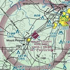
| Sectional chart |
|---|
|
| Airport distance calculator |
|---|
|
|
| Sunrise and sunset |
|---|
|
Times for 30-Apr-2026
| | Local
(UTC-5) | | Zulu
(UTC) |
|---|
| Morning civil twilight | | 05:32 | | 10:32 |
| Sunrise | | 05:59 | | 10:59 |
| Sunset | | 19:33 | | 00:33 |
| Evening civil twilight | | 20:00 | | 01:00 |
|
| Current date and time |
|---|
| Zulu (UTC) | 30-Apr-2026 19:58:33 |
|---|
| Local (UTC-5) | 30-Apr-2026 14:58:33 |
|---|
|
| METAR |
|---|
| KMRC | 301930Z AUTO 36005G11KT 10SM CLR 18/00 A2999 RMK A01
|
KLUG
19nm E | 301940Z AUTO 02007G16KT 10SM CLR 18/02 A2999 RMK A01
|
K2M2
20nm S | 301935Z AUTO 35008KT 10SM CLR 17/03 A2999 RMK A01
|
|
| NOTAMs |
|---|
NOTAMs are issued by the DoD/FAA and will open in a separate window not controlled by AirNav.
|
|

