FAA INFORMATION EFFECTIVE 16 APRIL 2026
Location
| FAA Identifier: | MWH |
| Lat/Long: | 47-12-30.9000N 119-19-08.9000W
47-12.515000N 119-19.148333W
47.2085833,-119.3191389
(estimated) |
| Elevation: | 1188.6 ft. / 362.3 m (surveyed) |
| Variation: | 18E (1995) |
| From city: | 5 miles NW of MOSES LAKE, WA |
| Time zone: | UTC -7 (UTC -8 during Standard Time) |
| Zip code: | 98837 |
Airport Operations
| Airport use: | Open to the public |
| Control tower: | yes |
| ARTCC: | SEATTLE CENTER |
| FSS: | SEATTLE FLIGHT SERVICE STATION |
| NOTAMs facility: | MWH (NOTAM-D service available) |
| Attendance: | CONTINUOUS |
| Wind indicator: | lighted |
| Segmented circle: | yes |
| Lights: | ACTVT MALSR RWY 32R; REIL RWY 4; PAPI RWY 14L - CTAF. |
| Beacon: | white-green (lighted land airport)
Operates sunset to sunrise. |
| Landing fee: | yes, OVR 12500 LB. |
| Fire and rescue: | ARFF index A |
| Airline operations: | PPR FOR ACR OPS GTR THAN 30 PAX SEATS 2200-0600 - 509-762-5363. ARFF DEP INDEX D H24. |
| International operations: | US CUSTOMS USER FEE ARPT. |
Airport Communications
| CTAF: | 118.25 |
| UNICOM: | 122.95 |
| ATIS: | 119.05 |
| WX ASOS: | 119.05 (509-762-5082) |
| GRANT COUNTY GROUND: | 121.9 [0600-2200] |
| GRANT COUNTY TOWER: | 118.25 ;EAST 128.0 ;WEST 257.8 ;EAST & WEST [0600-2200] |
| GRANT COUNTY APPROACH: | 126.4 379.95 [0600-2200] |
| SEATTLE ARTCC APPROACH: | 134.35 370.9 [2200-0600] |
| GRANT COUNTY DEPARTURE: | 126.4 379.95 [0600-2200] |
| SEATTLE ARTCC DEPARTURE: | 134.35 370.9 [2200-0600] |
| EMERG: | 121.5 243.0 |
| IC: | 126.4 379.95 |
| WX ASOS at EPH (10 nm NW): | 135.775 (509-754-3761) |
- APCH/DEP CTL SVC PRVDD BY SEATTLE ARTCC (ZSE) ON FREQS 126.1/291.6 (MARLIN RCAG) WHEN GRANT COUNTY APCH CTL (MHW) CLSD.
Nearby radio navigation aids
| VOR radial/distance | | VOR name | | Freq | | Var |
|---|
| MWH at field | | MOSES LAKE VOR/DME | | 115.00 | | 18E |
| EPHr136/11.0 | | EPHRATA VORTAC | | 112.60 | | 21E |
| EATr093/38.0 | | WENATCHEE VOR/DME | | 114.35 | | 15E |
| NDB name | | Hdg/Dist | | Freq | | Var | | ID |
|---|
| PELLY | | 324/5.9 | | 408 | | 18E | | MW | -- .-- |
Airport Services
| Fuel available: | 100LL JET-A JET-A1+ |
| Parking: | hangars and tiedowns |
| Airframe service: | MAJOR |
| Powerplant service: | MAJOR |
| Bulk oxygen: | HIGH |
Runway Information
Runway 14L/32R
| Dimensions: | 13503 x 200 ft. / 4116 x 61 m |
| Surface: | concrete/grooved, in good condition
RWY 32R FST 10000 FT GRVD 150 FT WIDE. |
| Weight bearing capacity: | | Single wheel: | 85.0 | | Double wheel: | 155.0 | | Double tandem: | 320.0 | | Dual double tandem: | 600.0 |
|
| Runway edge lights: | high intensity |
| RUNWAY 14L | | RUNWAY 32R |
| Latitude: | 47-13.539455N | | 47-11.425585N |
| Longitude: | 119-19.590510W | | 119-18.590360W |
| Elevation: | 1168.4 ft. | | 1166.5 ft. |
| Traffic pattern: | left | | right |
| Runway heading: | 144 magnetic, 162 true | | 324 magnetic, 342 true |
| Declared distances: | TORA:13503 TODA:13503 ASDA:13503 LDA:13503 | | TORA:13503 TODA:13503 ASDA:13492 LDA:13492 |
| Markings: | precision, in good condition | | precision, in good condition |
| Visual slope indicator: | 4-light PAPI on left (3.00 degrees glide path) | | 4-light PAPI on left (3.00 degrees glide path) |
| Approach lights: | | | MALSR: 1,400 foot medium intensity approach lighting system with runway alignment indicator lights |
| Runway end identifier lights: | yes | | |
| Touchdown point: | yes, no lights | | yes, no lights |
| Instrument approach: | | | ILS |
| Obstructions: | 25 ft. bldg, marked and lighted, 1081 ft. from runway, 35:1 slope to clear | | none |
Runway 4/22
| Dimensions: | 10000 x 100 ft. / 3048 x 30 m |
| Surface: | concrete/grooved, in good condition |
| Weight bearing capacity: | | Single wheel: | 75.0 | | Double wheel: | 100.0 | | Double tandem: | 175.0 | | Dual double tandem: | 475.0 |
|
| Runway edge lights: | medium intensity |
| RUNWAY 4 | | RUNWAY 22 |
| Latitude: | 47-11.803915N | | 47-12.766397N |
| Longitude: | 119-19.975542W | | 119-18.018303W |
| Elevation: | 1188.6 ft. | | 1153.4 ft. |
| Traffic pattern: | left | | right |
| Runway heading: | 036 magnetic, 054 true | | 216 magnetic, 234 true |
| Declared distances: | TORA:10000 TODA:10000 ASDA:10000 LDA:10000 | | TORA:10000 TODA:10000 ASDA:10000 LDA:10000 |
| Markings: | nonprecision, in good condition | | nonprecision, in good condition |
| Visual slope indicator: | 4-light PAPI on left (3.00 degrees glide path) | | 4-box VASI on left (3.00 degrees glide path) |
| Runway end identifier lights: | yes | | yes |
| Touchdown point: | yes, no lights | | yes, no lights |
Runway 9/27
| Dimensions: | 3500 x 90 ft. / 1067 x 27 m |
| Surface: | concrete/grooved, in good condition |
| Weight bearing capacity: | | Single wheel: | 100.0 | | Double wheel: | 150.0 | | Double tandem: | 270.0 | | Dual double tandem: | 475.0 |
|
| Runway edge lights: | non-standard
MIL LNDG ZONE LGTS ONLY. |
| Operational restrictions: | CLSD EXC MIL OPS; C-17 ASSAULT STRIP. NOT VIS FM ATCT. |
| RUNWAY 9 | | RUNWAY 27 |
| Latitude: | 47-13.059987N | | 47-12.880398N |
| Longitude: | 119-19.012835W | | 119-18.210065W |
| Elevation: | 1162.2 ft. | | 1152.9 ft. |
| Traffic pattern: | left | | right |
| Runway heading: | 090 magnetic, 108 true | | 270 magnetic, 288 true |
| Declared distances: | TORA:3500 TODA:3500 ASDA:3500 LDA:3500 | | TORA:3500 TODA:3500 ASDA:3500 LDA:3500 |
| Touchdown point: | yes, no lights | | yes, no lights |
Runway 18/36
| Dimensions: | 3327 x 75 ft. / 1014 x 23 m |
| Surface: | asphalt, in good condition |
| Weight bearing capacity: | | Single wheel: | 75.0 | | Double wheel: | 170.0 | | Double tandem: | 300.0 | | Dual double tandem: | 400.0 |
|
| Runway edge lights: | medium intensity |
| Operational restrictions: | ACR TWY MOV AREA ONLY. |
| RUNWAY 18 | | RUNWAY 36 |
| Latitude: | 47-12.496772N | | 47-11.976743N |
| Longitude: | 119-19.790743W | | 119-20.040857W |
| Elevation: | 1185.1 ft. | | 1184.8 ft. |
| Traffic pattern: | right | | left |
| Runway heading: | 180 magnetic, 198 true | | 000 magnetic, 018 true |
| Markings: | basic, in good condition | | basic, in good condition |
| Touchdown point: | yes, no lights | | yes, no lights |
Runway 14R/32L
| Dimensions: | 2936 x 75 ft. / 895 x 23 m |
| Surface: | concrete, in good condition |
| Weight bearing capacity: | | Single wheel: | 100.0 | | Double wheel: | 200.0 | | Double tandem: | 400.0 | | Dual double tandem: | 400.0 |
|
| RUNWAY 14R | | RUNWAY 32L |
| Latitude: | 47-13.441488N | | 47-12.981838N |
| Longitude: | 119-19.807462W | | 119-19.589787W |
| Elevation: | 1167.8 ft. | | 1169.6 ft. |
| Traffic pattern: | right | | left |
| Runway heading: | 144 magnetic, 162 true | | 324 magnetic, 342 true |
| Declared distances: | TORA:2936 TODA:2936 ASDA:2936 LDA:2936 | | TORA:2936 TODA:2936 ASDA:2936 LDA:2936 |
| Markings: | basic, in good condition | | basic, in good condition |
| Touchdown point: | yes, no lights | | yes, no lights |
| Obstructions: | 9 ft. gnd, 620 ft. from runway, 100 ft. right of centerline, 46:1 slope to clear | | none |
Helipad H1
| Dimensions: | 50 x 50 ft. / 15 x 15 m |
| Surface: | asphalt |
| Latitude: | 47-11.456667N | | |
| Longitude: | 119-19.393000W | | |
| Elevation: | 1176.0 ft. | | |
| Traffic pattern: | left | | left |
Helipad H2
| Dimensions: | 50 x 50 ft. / 15 x 15 m |
| Surface: | asphalt |
| Latitude: | 47-11.456500N | | |
| Longitude: | 119-19.691667W | | |
| Elevation: | 1185.0 ft. | | |
| Traffic pattern: | left | | left |
Airport Ownership and Management from official FAA records
| Ownership: | Publicly-owned |
| Owner: | PORT OF MOSES LAKE
7810 ANDREWS STREET NE
MOSES LAKE, WA 98837
Phone 509-762-5363 |
| Manager: | RICH MUELLER
7810 ANDREWS STREET NE
MOSES LAKE, WA 98837-3204
Phone 509-762-5363 |
Additional Remarks
| A39-18/36 | PCR VALUE: 120/R/A/W/T |
| A39-14R/32L | PCR VALUE: 580/R/A/W/T |
| A39-09/27 | PCR VALUE: 510/R/A/W/T |
| A39-14L/32R | PCR VALUE: 650/F/A/X/T |
| A39-04/22 | PCR VALUE: 565/R/A/W/T |
| - | BIRDS INVOF ARPT APR & OCT. |
| - | HVY JET TRNG SFC-5000 FT WI 25 MI; PSBL WAKE TURB FM RWY 09/27 & 14L/32R OPS. |
| - | TWY G UNLGTD. |
| - | HVY MIL JET NGT TRNG 1900-0300. WHEN ATCT CLSD ANNC LNDG INTNS - CTAF. |
| - | TWY F NOT VIS FM ATCT. |
| - | ALL RAPID RFL MIL HEL ACFT CTC MILLION AIR C509-762-2222 OR ON FREQ 131.625 FOR SVC ONE HR PRIOR TO LNDG. PROCD TO TRML RAMP. RAPID RFL IS AVBL DAYLT DLY. |
Instrument Procedures
NOTE: All procedures below are presented as PDF files. If you need a reader for these files, you should download the free Adobe Reader.NOT FOR NAVIGATION. Please procure official charts for flight.
FAA instrument procedures published for use from 16 April 2026 at 0901Z to 14 May 2026 at 0900Z.
IAPs - Instrument Approach Procedures |
|---|
| ILS OR LOC RWY 32R **CHANGED** | |
download (325KB) |
| RNAV (RNP) Z RWY 04 | |
download (237KB) |
| RNAV (RNP) Z RWY 14L | |
download (262KB) |
| RNAV (RNP) Z RWY 22 | |
download (219KB) |
| RNAV (RNP) Z RWY 32R | |
download (309KB) |
| RNAV (GPS) Y RWY 04 **CHANGED** | |
download (283KB) |
| RNAV (GPS) Y RWY 14L | |
download (287KB) |
| RNAV (GPS) Y RWY 22 **CHANGED** | |
download (267KB) |
| RNAV (GPS) Y RWY 32R | |
download (288KB) |
| VOR RWY 04 **CHANGED** | |
download (246KB) |
| VOR RWY 22 **CHANGED** | |
download (234KB) |
| VOR RWY 32R **CHANGED** | |
download (255KB) |
| VOR-1 RWY 14L | |
download (233KB) |
| VOR-3 RWY 14L | |
download (222KB) |
| NDB RWY 32R **CHANGED** | |
download (278KB) |
| NOTE: Special Alternate Minimums apply **CHANGED** | |
download (212KB) |
| NOTE: Special Take-Off Minimums/Departure Procedures apply | |
download (223KB) |
Other nearby airports with instrument procedures:
KEPH - Ephrata Municipal Airport (10 nm NW)
KEAT - Pangborn Memorial Airport (38 nm W)
2S8 - Wilbur Airport (40 nm NE)
3W7 - Grand Coulee Dam Airport (44 nm N)
KELN - Bowers Field Airport (50 nm W)
|
|

Road maps at:
MapQuest
Bing
Google
| Aerial photo |
|---|
WARNING: Photo may not be current or correct
 Photo by Sandor Paulay
Photo taken 13-Aug-2016
looking south.
Photo by Sandor Paulay
Photo taken 13-Aug-2016
looking south.
Do you have a better or more recent aerial photo of Grant County International Airport that you would like to share? If so, please send us your photo.
|
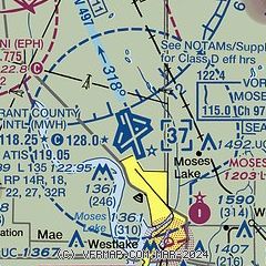
| Sectional chart |
|---|
|
CAUTION: Diagram may not be current
 Download PDF
of official airport diagram from the FAA
| Airport distance calculator |
|---|
|
|
| Sunrise and sunset |
|---|
|
Times for 16-Apr-2026
| | Local
(UTC-7) | | Zulu
(UTC) |
|---|
| Morning civil twilight | | 05:36 | | 12:36 |
| Sunrise | | 06:08 | | 13:08 |
| Sunset | | 19:46 | | 02:46 |
| Evening civil twilight | | 20:18 | | 03:18 |
|
| Current date and time |
|---|
| Zulu (UTC) | 17-Apr-2026 04:06:51 |
|---|
| Local (UTC-7) | 16-Apr-2026 21:06:51 |
|---|
|
| METAR |
|---|
| KMWH | 170352Z 26009KT 10SM CLR 08/M06 A3012 RMK AO2 SLP255 T00781056
|
KEPH
10nm NW | 170353Z AUTO 30015KT 10SM CLR 07/M06 A3010 RMK AO2 SLP197 T00721061
|
|
| TAF |
|---|
| KMWH | 161720Z 1618/1718 VRB04KT P6SM SKC FM162100 27013G21KT P6SM SCT250 FM170300 29007KT P6SM SKC
|
|
| NOTAMs |
|---|
NOTAMs are issued by the DoD/FAA and will open in a separate window not controlled by AirNav.
|
|


