FAA INFORMATION EFFECTIVE 19 FEBRUARY 2026
Location
| FAA Identifier: | NVD |
| Lat/Long: | 37-51-08.9161N 094-18-16.5879W
37-51.148602N 094-18.276465W
37.8524767,-94.3046078
(estimated) |
| Elevation: | 892 ft. / 271.9 m (surveyed) |
| Variation: | 02E (2010) |
| From city: | 3 miles NE of NEVADA, MO |
| Time zone: | UTC -6 (UTC -5 during Daylight Saving Time) |
| Zip code: | 64772 |
Airport Operations
| Airport use: | Open to the public |
| Activation date: | 03/1941 |
| Control tower: | no |
| ARTCC: | KANSAS CITY CENTER |
| FSS: | COLUMBIA FLIGHT SERVICE STATION |
| NOTAMs facility: | COU (NOTAM-D service available) |
| Attendance: | 0730-DUSK |
| Wind indicator: | lighted |
| Segmented circle: | yes |
| Lights: | ACTVT REILS RWYS 02 & 20; PAPI RWYS 02 & 20; MIRLS RWY 02/20 AFTER SS - CTAF. REILS RWYS 02 & 20; PAPI RWYS 02 & 20; MIRLS RWYS 02 & 20 NOT AVBL SR - SS. |
| Beacon: | white-green (lighted land airport)
Operates sunset to sunrise. |
Airport Communications
| CTAF/UNICOM: | 122.8 |
| WX AWOS-3PT: | 119.175 (417-448-1635) |
- APCH/DEP SVC PRVDD BY KANSAS CITY ARTCC ON FREQS 125.55/327.0 (BUTLER RCAG).
Nearby radio navigation aids
| VOR radial/distance | | VOR name | | Freq | | Var |
|---|
| BUMr154/26.6 | | BUTLER VORTAC | | 115.90 | | 07E |
Airport Services
| Fuel available: | 100LL JET-A |
| Parking: | tiedowns |
| Airframe service: | MINOR |
| Powerplant service: | MINOR |
| Bulk oxygen: | NONE |
Runway Information
Runway 2/20
| Dimensions: | 5000 x 75 ft. / 1524 x 23 m |
| Surface: | concrete, in good condition |
| Weight bearing capacity: | | Single wheel: | 20.0 | | Double wheel: | 42.0 |
|
| Runway edge lights: | medium intensity |
| Runway edge markings: | MARKINGS FADED |
| RUNWAY 2 | | RUNWAY 20 |
| Latitude: | 37-50.768353N | | 37-51.505605N |
| Longitude: | 094-18.521803W | | 094-18.058260W |
| Elevation: | 890.0 ft. | | 881.2 ft. |
| Traffic pattern: | left | | left |
| Runway heading: | 024 magnetic, 026 true | | 205 magnetic, 207 true |
| Markings: | nonprecision, in fair condition | | nonprecision, in fair condition |
| Visual slope indicator: | 4-light PAPI on left (3.00 degrees glide path) | | 4-light PAPI on left (3.00 degrees glide path) |
| Runway end identifier lights: | yes | | yes |
| Touchdown point: | yes, no lights | | yes, no lights |
| Obstructions: | 56 ft. tree, 1210 ft. from runway, 302 ft. right of centerline, 18:1 slope to clear | | 45 ft. trees, 1365 ft. from runway, 323 ft. right of centerline, 25:1 slope to clear |
Runway 13/31
| Dimensions: | 2581 x 40 ft. / 787 x 12 m |
| Surface: | asphalt, in poor condition
RWY 13/31 PAVEMENT CRACKED WITH LOOSE ASPH CHIPS & VEGETATION GROWING IN CRACKS. |
| Weight bearing capacity: | | Single wheel: | 19.0, LIMITED BY AMGR TO 8000 LBS SINGLE WHEEL GEAR. |
|
| RUNWAY 13 | | RUNWAY 31 |
| Latitude: | 37-51.322567N | | 37-51.019667N |
| Longitude: | 094-18.438467W | | 094-18.061900W |
| Elevation: | 877.0 ft. | | 874.0 ft. |
| Traffic pattern: | left | | left |
| Runway heading: | 133 magnetic, 135 true | | 313 magnetic, 315 true |
| Touchdown point: | yes, no lights | | yes, no lights |
| Obstructions: | 39 ft. trees, 836 ft. from runway, 170 ft. right of centerline, 16:1 slope to clear
COUNTY ROAD 189-483 FT FM RY END 125 FT R AND L. | | 34 ft. trees, 625 ft. from runway, 112 ft. both sides of centerline, 12:1 slope to clear |
Airport Ownership and Management from official FAA records
| Ownership: | Publicly-owned |
| Owner: | CITY OF NEVADA
110 S ASH
NEVADA, MO 64772
Phone 417-448-4467 |
| Manager: | JODY BRYSON
18098 EAST 54 HIGHWAY
NEVADA, MO 65772
Phone 417-448-4488 |
Additional Remarks
| - | WILDLIFE ON & INVOF RY DUSK-DAWN. |
| - | CROP DUSTING ACFT ON & INVOF ARPT. |
| - | FOR CD CTC KANSAS CITY ARTCC AT 913-254-8508. |
Instrument Procedures
NOTE: All procedures below are presented as PDF files. If you need a reader for these files, you should download the free Adobe Reader.NOT FOR NAVIGATION. Please procure official charts for flight.
FAA instrument procedures published for use from 19 February 2026 at 0901Z to 19 March 2026 at 0900Z.
IAPs - Instrument Approach Procedures |
|---|
| RNAV (GPS) RWY 02 | |
download (247KB) |
| RNAV (GPS) RWY 20 | |
download (236KB) |
| VOR-A | |
download (180KB) |
| NOTE: Special Take-Off Minimums/Departure Procedures apply | |
download (429KB) |
Other nearby airports with instrument procedures:
KLLU - Lamar Municipal Airport (22 nm S)
KFSK - Fort Scott Municipal Airport (22 nm W)
MO3 - Stockton Lake Airport (26 nm SE)
KBUM - Butler Memorial Airport (26 nm N)
KPTS - Atkinson Municipal Airport (32 nm SW)
|
|

Road maps at:
MapQuest
Bing
Google
| Aerial photo |
|---|
WARNING: Photo may not be current or correct
 Photo by Eve Cascella
Photo taken 22-Sep-2013
looking north.
Photo by Eve Cascella
Photo taken 22-Sep-2013
looking north.
Do you have a better or more recent aerial photo of Nevada Municipal Airport that you would like to share? If so, please send us your photo.
|
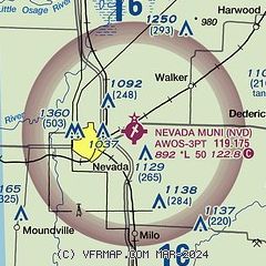
| Sectional chart |
|---|
|
| Airport distance calculator |
|---|
|
|
| Sunrise and sunset |
|---|
|
Times for 06-Mar-2026
| | Local
(UTC-6) | | Zulu
(UTC) |
|---|
| Morning civil twilight | | 06:16 | | 12:16 |
| Sunrise | | 06:43 | | 12:43 |
| Sunset | | 18:14 | | 00:14 |
| Evening civil twilight | | 18:41 | | 00:41 |
|
| Current date and time |
|---|
| Zulu (UTC) | 06-Mar-2026 19:23:18 |
|---|
| Local (UTC-6) | 06-Mar-2026 13:23:18 |
|---|
|
| METAR |
|---|
KFSK
22nm W | 061855Z AUTO 20015G20KT 10SM OVC034 22/16 A2983 RMK AO2 T02210156
|
KPTS
32nm SW | 061855Z AUTO 20017G30KT 10SM SCT038 BKN047 OVC120 22/17 A2984 RMK AO2 PK WND 19030/59
|
KGLY
42nm NE | 061855Z AUTO 22012G20KT 10SM SCT047 BKN055 BKN065 24/15 A2986 RMK AO2 LTG DSNT N
|
KJLN
43nm S | 061853Z 20020G39KT 10SM BKN039 OVC060 23/15 A2986 RMK AO2 PK WND 19039/1850 SLP102 T02280150
|
|
| TAF |
|---|
KJLN
43nm S | 061720Z 0618/0718 20019G29KT P6SM BKN035 FM062000 18017G28KT P6SM SCT035 PROB30 0620/0624 1SM TSRA BKN025CB FM070000 17016G24KT 2SM TSRA BKN020CB PROB30 0706/0708 4SM +TSRA BR OVC025CB FM071000 20014G23KT P6SM BKN015
|
|
| NOTAMs |
|---|
NOTAMs are issued by the DoD/FAA and will open in a separate window not controlled by AirNav.
|
|

