FAA INFORMATION EFFECTIVE 09 JULY 2026
Location
| FAA Identifier: | O41 |
| Lat/Long: | 38-40-25.9550N 121-52-19.4780W
38-40.432583N 121-52.324633W
38.6738764,-121.8720772
(estimated) |
| Elevation: | 125 ft. / 38.1 m (surveyed) |
| Variation: | 14E (2010) |
| From city: | 4 miles W of WOODLAND, CA |
| Time zone: | UTC -7 (UTC -8 during Standard Time) |
| Zip code: | 95695 |
Airport Operations
| Airport use: | Open to the public |
| Activation date: | 07/1940 |
| Control tower: | no |
| ARTCC: | OAKLAND CENTER |
| FSS: | RANCHO MURIETA FLIGHT SERVICE STATION |
| NOTAMs facility: | RIU (NOTAM-D service available) |
| Attendance: | OCT-APR 0800-1700, MAY-SEP 0700-1800 |
| Pattern altitude: | TPA FOR TURBINE ACFT 1500 FT AGL; TPA FOR OTHER ACFT 1000 FT AGL. |
| Wind indicator: | lighted |
| Segmented circle: | no |
| Lights: | ACTVT MIRL RY 18/36 - CTAF. |
| Beacon: | white-green (lighted land airport)
Operates sunset to sunrise. |
Airport Communications
| CTAF/UNICOM: | 122.8 |
| TRAVIS APPROACH: | 126.6 |
| TRAVIS DEPARTURE: | 126.6 |
| WX AWOS-3P at DWA (6 nm S): | 125.775 (530-750-2759) |
| WX AWOS-3 at EDU (9 nm SE): | 119.025 (530-754-6839) |
| WX ASOS at SMF (13 nm E): | PHONE 916-649-3996 |
| WX ASOS at VCB (18 nm S): | 134.75 (707-240-8032) |
Nearby radio navigation aids
| VOR radial/distance | | VOR name | | Freq | | Var |
|---|
| SACr296/20.4 | | SACRAMENTO VORTAC | | 115.20 | | 17E |
| MCCr254/21.9 | | MC CLELLAN VOR/DME | | 109.20 | | 17E |
| ILAr145/24.9 | | WILLIAMS VORTAC | | 114.40 | | 18E |
| MYVr193/29.1 | | MARYSVILLE VOR/DME | | 110.80 | | 16E |
| SGDr021/37.9 | | SCAGGS ISLAND VORTAC | | 112.10 | | 17E |
| CCRr355/38.6 | | CONCORD VOR/DME | | 117.00 | | 17E |
Airport Services
| Fuel available: | 100LL
100LL:FUEL 24 HRS WITH CREDIT CARD. |
| Parking: | hangars and tiedowns |
| Airframe service: | MAJOR |
| Powerplant service: | MAJOR |
| Bottled oxygen: | HIGH/LOW |
| Bulk oxygen: | NONE |
Runway Information
Runway 18/36
| Dimensions: | 3759 x 60 ft. / 1146 x 18 m |
| Surface: | asphalt, in fair condition |
| Weight bearing capacity: | | Single wheel: | 12.0, GROSS PAVEMENT STRENGTH PRVDD BY MGR; 12000 LBS. |
|
| Runway edge lights: | medium intensity |
| Runway edge markings: | SVRLY FADED RWY MRKGS. |
| RUNWAY 18 | | RUNWAY 36 |
| Latitude: | 38-40.724833N | | 38-40.139967N |
| Longitude: | 121-52.195333W | | 121-52.455267W |
| Elevation: | 107.0 ft. | | 124.0 ft. |
| Traffic pattern: | left | | left |
| Runway heading: | 185 magnetic, 199 true | | 005 magnetic, 019 true |
| Displaced threshold: | 630 ft. | | 385 ft. |
| Declared distances: | TORA:3759 TODA:3759 ASDA:3559 LDA:2929 | | TORA:3759 TODA:3759 ASDA:3629 LDA:3244 |
| Markings: | basic, in poor condition | | basic, in poor condition |
| Runway end identifier lights: | no | | no |
| Touchdown point: | yes, no lights | | yes, no lights |
| Obstructions: | 36 ft. trees, 600 ft. from runway, 209 ft. right of centerline, 11:1 slope to clear
+15 FT ROAD 125 FT FM EOR AND +20 FT BUSHES AND TREE 100 FT RIGHT 75 FT FM EOR. | | 20 ft. ant, 300 ft. from runway, 100 ft. right of centerline, 5:1 slope to clear
RWY 36 +4' FENCE 55' & ROAD 80' FROM THR. |
Airport Ownership and Management from official FAA records
| Ownership: | Privately-owned |
| Owner: | WATTS-WOODLAND AIRPORT INC.
17992 COUNTY ROAD 94B
WOODLAND, CA 95695
Phone 530-867-6652 |
| Manager: | MILTON B. WATTS
17992 COUNTY ROAD 94B
WOODLAND, CA 95695
Phone 530-867-6652 |
Additional Remarks
| - | TWIN ENGINE ACFT BACK TAXI ON RY. |
| - | RY 18 UNLGTD 60 FT TREES HIGHER THAN POLE MOUNTED OBSTN LGTS. |
| - | FOR CD CTC OAKLAND ARTCC AT 510-745-3380. |
Instrument Procedures
NOTE: All procedures below are presented as PDF files. If you need a reader for these files, you should download the free Adobe Reader.NOT FOR NAVIGATION. Please procure official charts for flight.
FAA instrument procedures published for use from 09 July 2026 at 0901Z to 06 August 2026 at 0900Z.
IAPs - Instrument Approach Procedures |
|---|
| RNAV (GPS) RWY 36 | |
download (168KB) |
| NOTE: Special Take-Off Minimums/Departure Procedures apply | |
download (128KB) |
Other nearby airports with instrument procedures:
KDWA - Yolo County Airport (6 nm S)
KEDU - University Airport (9 nm SE)
KSMF - Sacramento International Airport (13 nm E)
KVCB - Nut Tree Airport (18 nm S)
KSAC - Sacramento Executive Airport (20 nm SE)
|
|

Road maps at:
MapQuest
Bing
Google
| Aerial photo |
|---|
WARNING: Photo may not be current or correct
 Taken in October 2009
Do you have a better or more recent aerial photo of Watts-Woodland Airport that you would like to share? If so, please send us your photo.
|
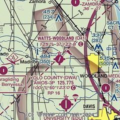
| Sectional chart |
|---|
|
CAUTION: Diagram may not be current

| Airport distance calculator |
|---|
|
|
| Sunrise and sunset |
|---|
|
Times for 20-Jul-2026
| | Local
(UTC-7) | | Zulu
(UTC) |
|---|
| Morning civil twilight | | 05:29 | | 12:29 |
| Sunrise | | 06:00 | | 13:00 |
| Sunset | | 20:28 | | 03:28 |
| Evening civil twilight | | 20:58 | | 03:58 |
|
| Current date and time |
|---|
| Zulu (UTC) | 21-Jul-2026 03:20:06 |
|---|
| Local (UTC-7) | 20-Jul-2026 20:20:06 |
|---|
|
| METAR |
|---|
KDWA
6nm S | 210255Z AUTO 14003KT 10SM CLR 29/13 A2987 RMK AO2
|
KEDU
9nm SE | 210300Z AUTO 14005KT 10SM CLR 27/14 A2986 RMK AO1
|
KSMF
13nm E | 210253Z 17007KT 10SM BKN160 29/08 A2985 RMK AO2 SLP106 T02940078 56003
|
KVCB
18nm S | 210253Z AUTO 20003KT 10SM FEW120 29/11 A2986 RMK AO2 SLP108 T02940106 55006
|
|
| TAF |
|---|
KSMF
13nm E | 201720Z 2018/2118 17010KT P6SM FEW250 FM210600 16006KT P6SM BKN250
|
|
| NOTAMs |
|---|
NOTAMs are issued by the DoD/FAA and will open in a separate window not controlled by AirNav.
|
|


