FAA INFORMATION EFFECTIVE 14 MAY 2026
Location
| FAA Identifier: | OSH |
| Lat/Long: | 43-59-03.7350N 088-33-25.3530W
43-59.062250N 088-33.422550W
43.9843708,-88.5570425
(estimated) |
| Elevation: | 808.5 ft. / 246.4 m (surveyed) |
| Variation: | 03W (2015) |
| From city: | 2 miles S of OSHKOSH, WI |
| Time zone: | UTC -5 (UTC -6 during Standard Time) |
| Zip code: | 54902 |
Airport Operations
| Airport use: | Open to the public |
| Activation date: | 10/1937 |
| Control tower: | yes |
| ARTCC: | CHICAGO CENTER |
| FSS: | GREEN BAY FLIGHT SERVICE STATION |
| NOTAMs facility: | OSH (NOTAM-D service available) |
| Attendance: | MON-FRI 0700-1900, ALL SAT-SUN 0800-1700 |
| Wind indicator: | lighted |
| Segmented circle: | no |
| Lights: | WHEN ATCT CLSD, ACTVT MALSR RWY 36; REIL RWY 18 & 27; HIRL RWY 09/27 & 18/36 - CTAF. HIRL 18/36 PRESET ON LOW INTST SS-SR, TO INCR INTST & ACTVT - CTAF. PAPI RWY 09, 27, 18 & 36 OPR CONSLY. |
| Beacon: | white-green (lighted land airport)
Operates sunset to sunrise. |
Airport Communications
| CTAF: | 118.5 |
| UNICOM: | 122.95 |
| ATIS: | 125.9 |
| WX ASOS: | PHONE 920-426-1644 |
| OSHKOSH GROUND: | 132.3 [16 MAR-31 OCT 0600-2200, 1 NOV-15 MAR 0600-2100] |
| OSHKOSH TOWER: | 118.5 290.9 [16 MAR-31 OCT 0600-2200, 1 NOV-15 MAR 0600-2100] |
| MILWAUKEE APPROACH: | 127.0 |
| MILWAUKEE DEPARTURE: | 127.0 |
| EMERG: | 121.5 243.0 |
| WX ASOS at FLD (13 nm S): | 134.0 (920-922-4444) |
| WX AWOS-3 at ATW (17 nm N): | PHONE 920-832-2597 |
Nearby radio navigation aids
| VOR radial/distance | | VOR name | | Freq | | Var |
|---|
| OSH at field | | OSHKOSH VOR/DME | | 116.75 | | 02E |
| GRBr203/37.6 | | GREEN BAY VORTAC | | 115.50 | | 01E |
| BJBr332/(38.6) | | WEST BEND VOR | | 109.80 | | 01W |
| NDB name | | Hdg/Dist | | Freq | | Var | | ID |
|---|
| POBER | | 003/6.6 | | 395 | | 03W | | OS | --- ... |
Airport Services
| Fuel available: | 100LL JET-A+
A+:A+ AND 100LL AVBL FOR FEE AFTER HRS, 920-236-7827. |
| Parking: | hangars and tiedowns |
| Airframe service: | MAJOR |
| Powerplant service: | MAJOR |
| Bottled oxygen: | NONE |
| Bulk oxygen: | HIGH/LOW |
Runway Information
Runway 18/36
| Dimensions: | 8002 x 150 ft. / 2439 x 46 m |
| Surface: | concrete/grooved, in good condition |
| Weight bearing capacity: | | Single wheel: | 65.0 | | Double wheel: | 85.0 | | Double tandem: | 130.0 |
|
| Runway edge lights: | high intensity |
| RUNWAY 18 | | RUNWAY 36 |
| Latitude: | 43-59.147338N | | 43-57.830388N |
| Longitude: | 088-33.385640W | | 088-33.402920W |
| Elevation: | 789.6 ft. | | 808.4 ft. |
| Traffic pattern: | left | | left |
| Runway heading: | 184 magnetic, 181 true | | 004 magnetic, 001 true |
| Markings: | precision, in good condition | | precision, in good condition |
| Visual slope indicator: | 4-light PAPI on left (3.00 degrees glide path) | | 4-light PAPI on left (3.00 degrees glide path) |
| RVR equipment: | rollout | | touchdown |
| Approach lights: | | | MALSR: 1,400 foot medium intensity approach lighting system with runway alignment indicator lights |
| Runway end identifier lights: | yes | | no |
| Touchdown point: | yes, no lights | | yes, no lights |
| Instrument approach: | | | ILS |
| Obstructions: | 15 ft. ant, 550 ft. from runway, 250 ft. left of centerline, 23:1 slope to clear | | 61 ft. trees, 3000 ft. from runway, 185 ft. left of centerline, 45:1 slope to clear |
Runway 9/27
| Dimensions: | 6179 x 150 ft. / 1883 x 46 m |
| Surface: | concrete/grooved, in good condition |
| Weight bearing capacity: | | Single wheel: | 75.0 | | Double wheel: | 125.0 | | Double tandem: | 185.0 |
|
| Runway edge lights: | high intensity |
| RUNWAY 9 | | RUNWAY 27 |
| Latitude: | 43-59.498298N | | 43-59.488532N |
| Longitude: | 088-34.327810W | | 088-32.919172W |
| Elevation: | 797.5 ft. | | 775.8 ft. |
| Traffic pattern: | left | | left |
| Runway heading: | 094 magnetic, 091 true | | 274 magnetic, 271 true |
| Displaced threshold: | no | | 531 ft. |
| Declared distances: | TORA:6179 TODA:6179 ASDA:5648 LDA:5648 | | TORA:6179 TODA:6179 ASDA:6179 LDA:5648 |
| Markings: | nonprecision, in good condition | | nonprecision, in good condition |
| Visual slope indicator: | 4-light PAPI on left (3.00 degrees glide path) | | 4-light PAPI on left (3.00 degrees glide path) |
| Runway end identifier lights: | no | | yes |
| Touchdown point: | yes, no lights | | yes, no lights |
| Obstructions: | none | | 37 ft. tree, 720 ft. from runway, 150 ft. right of centerline, 14:1 slope to clear
APCH RATIO 34:1 TO DTHR. |
Runway 5/23
| Dimensions: | 3424 x 75 ft. / 1044 x 23 m |
| Surface: | asphalt, in fair condition |
| Weight bearing capacity: | | Single wheel: | MAXIMUM WEIGHT BEARING CAPACITY FOR ANY ACFT IS 50000 LBS. |
|
| RUNWAY 5 | | RUNWAY 23 |
| Latitude: | 43-59.198897N | | 43-59.597987N |
| Longitude: | 088-33.500000W | | 088-32.949017W |
| Elevation: | 790.3 ft. | | 775.2 ft. |
| Traffic pattern: | left | | left |
| Runway heading: | 048 magnetic, 045 true | | 228 magnetic, 225 true |
| Markings: | basic, in fair condition | | basic, in fair condition |
| Runway end identifier lights: | no | | no |
| Touchdown point: | yes, no lights | | yes, no lights |
| Obstructions: | none | | 21 ft. rr, 500 ft. from runway, 155 ft. left of centerline, 14:1 slope to clear |
Runway 13/31
| Dimensions: | 3061 x 75 ft. / 933 x 23 m |
| Surface: | asphalt, in fair condition |
| Weight bearing capacity: | | Single wheel: | MAXIMUM WEIGHT BEARING CAPACITY FOR ANY ACFT IS 50000 LBS. |
|
| RUNWAY 13 | | RUNWAY 31 |
| Latitude: | 43-59.474647N | | 43-59.154713N |
| Longitude: | 088-33.581975W | | 088-33.042828W |
| Elevation: | 781.7 ft. | | 781.2 ft. |
| Traffic pattern: | left | | left |
| Runway heading: | 132 magnetic, 129 true | | 312 magnetic, 309 true |
| Markings: | basic, in fair condition | | basic, in fair condition |
| Runway end identifier lights: | no | | no |
| Touchdown point: | yes, no lights | | yes, no lights |
| Obstructions: | none | | 15 ft. road, 217 ft. from runway, 127 ft. right of centerline, 1:1 slope to clear |
Airport Ownership and Management from official FAA records
| Ownership: | Publicly-owned |
| Owner: | WINNEBAGO COUNTY
415 JACKSON ST
OSHKOSH, WI 54901
Phone 920-236-4930 |
| Manager: | JAMES SCHELL
525 W 20TH AVE
OSHKOSH, WI 54902
Phone 920-236-4930
JSCHELL@WINNEBAGOCOUNTYWI.GOV. |
Additional Remarks
| - | FOR CD IF UNA TO CTC ON FSS FREQ, CTC CHICAGO ARTCC AT 630-906-8921. |
| - | SFC CONDS NOT MONTRD BTWN 2200 - 0500 HRS. |
| - | BIRDS ON & INVOF ARPT. |
| - | RWYS 13/31, 05/23 & TWYS C, H, P NOT AVBL TO ACFT WITH MORE THAN 30 PSGR SEATS. |
| - | RY 23 & RY 27 APCH ENDS ARE CLOSELY ALIGNED. VERIFY CORRECT RY AND COMPASS HEADING PRIOR TO DEP. |
Instrument Procedures
NOTE: All procedures below are presented as PDF files. If you need a reader for these files, you should download the free Adobe Reader.NOT FOR NAVIGATION. Please procure official charts for flight.
FAA instrument procedures published for use from 14 May 2026 at 0901Z to 11 June 2026 at 0900Z.
IAPs - Instrument Approach Procedures |
|---|
| ILS OR LOC RWY 36 | |
download (289KB) |
| RNAV (GPS) RWY 09 | |
download (302KB) |
| RNAV (GPS) RWY 18 | |
download (289KB) |
| RNAV (GPS) RWY 27 | |
download (283KB) |
| RNAV (GPS) RWY 36 | |
download (293KB) |
| LOC BC RWY 18 **CHANGED** | |
download (281KB) |
| VOR RWY 09 | |
download (262KB) |
| VOR RWY 18 | |
download (262KB) |
| VOR RWY 27 | |
download (222KB) |
| VOR RWY 36 | |
download (277KB) |
| NOTE: Special Alternate Minimums apply | |
download (162KB) |
| NOTE: Special Take-Off Minimums/Departure Procedures apply | |
download (518KB) |
Other nearby airports with instrument procedures:
KFLD - Fond Du Lac County Airport (13 nm S)
KATW - Appleton International Airport (17 nm N)
8D1 - New Holstein Municipal Airport (19 nm E)
KPCZ - Waupaca Municipal Airport (29 nm NW)
Y50 - Wautoma Municipal Airport (32 nm W)
|
|

Road maps at:
MapQuest
Bing
Google
| Aerial photo |
|---|
WARNING: Photo may not be current or correct
 Photo taken 22-Jun-2019
looking east.
Photo taken 22-Jun-2019
looking east.
Do you have a better or more recent aerial photo of Wittman Regional Airport that you would like to share? If so, please send us your photo.
|
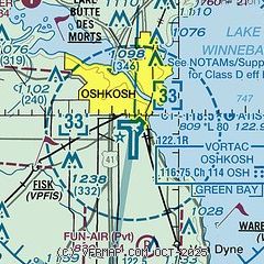
| Sectional chart |
|---|
|
CAUTION: Diagram may not be current
 Download PDF
of official airport diagram from the FAA
| Airport distance calculator |
|---|
|
|
| Sunrise and sunset |
|---|
|
Times for 09-Jun-2026
| | Local
(UTC-5) | | Zulu
(UTC) |
|---|
| Morning civil twilight | | 04:36 | | 09:36 |
| Sunrise | | 05:12 | | 10:12 |
| Sunset | | 20:34 | | 01:34 |
| Evening civil twilight | | 21:10 | | 02:10 |
|
| Current date and time |
|---|
| Zulu (UTC) | 09-Jun-2026 14:13:22 |
|---|
| Local (UTC-5) | 09-Jun-2026 09:13:22 |
|---|
|
| METAR |
|---|
| KOSH | 091353Z 02003KT 5SM BR OVC007 21/19 A2992 RMK AO2 SLP119 T02060194
|
KFLD
13nm S | 091353Z AUTO 33004KT 7SM OVC008 22/20 A2992 RMK AO2 SLP129 T02220200
|
KATW
16nm N | 091345Z 32005KT 4SM BR OVC004 22/21 A2994
|
|
| TAF |
|---|
KATW
16nm N | 091139Z 0912/1012 04004KT 4SM BR OVC007 TEMPO 0912/0915 2SM BR OVC005 FM091500 03007G13KT P6SM BKN007 FM091800 02009G14KT P6SM BKN018 FM092000 06004KT P6SM SCT030 FM100600 14003KT 4SM BR BKN008 PROB30 1010/1012 6SM -TSRA SCT008 BKN011CB
|
|
| NOTAMs |
|---|
NOTAMs are issued by the DoD/FAA and will open in a separate window not controlled by AirNav.
|
|


