FAA INFORMATION EFFECTIVE 27 NOVEMBER 2025
Location
| FAA Identifier: | OSU |
| Lat/Long: | 40-04-46.2560N 083-04-23.5660W
40-04.770933N 083-04.392767W
40.0795156,-83.0732128
(estimated) |
| Elevation: | 905.5 ft. / 276.0 m (surveyed) |
| Variation: | 05W (1990) |
| From city: | 10 miles NW of COLUMBUS, OH |
| Time zone: | UTC -5 (UTC -4 during Daylight Saving Time) |
| Zip code: | 43017 |
Airport Operations
| Airport use: | Open to the public |
| Activation date: | 08/1943 |
| Control tower: | yes |
| ARTCC: | INDIANAPOLIS CENTER |
| FSS: | DAYTON FLIGHT SERVICE STATION |
| NOTAMs facility: | OSU (NOTAM-D service available) |
| Attendance: | 0600-2300 |
| Wind indicator: | lighted |
| Segmented circle: | yes |
| Lights: | WHEN ATCT CLSD ACTVT MALSR RWY 09R - CTAF. REIL RWY 27L; PAPI RWY 09R & 27L; VASI RWY 09L & 27R; HIRL RWY 09R/27L - OPR CONSLY MED INTST. MIRL RWY 09L/27R - OPR CONSLY LOW INTST. |
| Beacon: | white-green (lighted land airport)
Operates sunset to sunrise. |
| Fire and rescue: | ARFF index A |
Airport Communications
| CTAF: | 118.8 |
| UNICOM: | 122.95 |
| ATIS: | 121.35 |
| WX ASOS: | 121.35 (614-451-2465) |
| STATE GROUND: | 121.7 [0700-2300] |
| STATE TOWER: | 118.8 254.325 [0700-2300] |
| COLUMBUS APPROACH: | 125.95 |
| COLUMBUS DEPARTURE: | 125.95 |
| CLEARANCE DELIVERY: | 121.7 |
| CBUSS STAR: | 125.95 |
| DUBLN STAR: | 125.95 |
| IC: | 125.95 |
| NG OPS: | 123.075 46.8FM |
| WX ASOS at CMH (10 nm SE): | 124.6 (614-333-9354) |
| WX AWOS-3PT at TZR (11 nm S): | 135.925 (614-878-1722) |
| WX AWOS-3 at DLZ (12 nm N): | 119.025 (740-203-1878) |
| WX AWOS-3 at MRT (15 nm NW): | 119.275 (937-644-2967) |
| WX AWOS-3 at LCK (17 nm SE): | PHONE 614-492-2441 |
| WX AWOS-3PT at UYF (20 nm SW): | 120.85 (740-852-2844) |
Nearby radio navigation aids
| VOR radial/distance | | VOR name | | Freq | | Var |
|---|
| APEr265/22.7 | | APPLETON VORTAC | | 116.70 | | 06W |
| BUDr186/(32.2) | | BUCKEYE VOR | | 109.80 | | 05W |
| XUBr357/(33.4) | | YELLOW BUD VOR | | 112.50 | | 05W |
| NDB name | | Hdg/Dist | | Freq | | Var | | ID |
|---|
| FULER | | 091/5.7 | | 515 | | 05W | | OS | --- ... |
| COURT HOUSE | | 033/32.2 | | 414 | | 06W | | CSS | -.-. ... ... |
Airport Services
| Fuel available: | 100LL JET-A1+ |
| Parking: | hangars and tiedowns |
| Airframe service: | MAJOR |
| Powerplant service: | MAJOR |
| Bulk oxygen: | HIGH/LOW |
Runway Information
Runway 9R/27L
| Dimensions: | 5004 x 100 ft. / 1525 x 30 m |
| Surface: | asphalt/grooved, in good condition |
| Weight bearing capacity: | | Single wheel: | 120.0 | | Double wheel: | 250.0 | | Double tandem: | 550.0 | | Dual double tandem: | 1061.0 |
|
| Runway edge lights: | high intensity |
| Operational restrictions: | RWY 09R/27L NOT AVBL FOR PART 121/PART 380 OPS WITH SKED PAX CARRYING OPS MORE THAN 9 PAX SEATS AND NON-SKED PAX CARRYING OPS MORE THAN 30 PAX SEATS. 90 DAY PPR FOR UNSKED ACR OPS GTR THAN 30 PAX SEATS - CALL AMGR. |
| RUNWAY 9R | | RUNWAY 27L |
| Latitude: | 40-04.628820N | | 40-04.670905N |
| Longitude: | 083-04.896158W | | 083-03.824775W |
| Elevation: | 901.3 ft. | | 889.6 ft. |
| Traffic pattern: | left | | left |
| Runway heading: | 092 magnetic, 087 true | | 272 magnetic, 267 true |
| Declared distances: | TORA:5004 TODA:5004 ASDA:5004 LDA:5004 | | TORA:5004 TODA:5004 ASDA:5004 LDA:5004 |
| Markings: | precision, in good condition | | nonprecision, in good condition |
| Visual slope indicator: | 4-light PAPI on left (3.00 degrees glide path) | | 4-light PAPI on left (3.00 degrees glide path) |
| Approach lights: | MALSR: 1,400 foot medium intensity approach lighting system with runway alignment indicator lights | | |
| Runway end identifier lights: | | | yes |
| Touchdown point: | yes, no lights | | yes, no lights |
| Instrument approach: | ILS | | |
| Obstructions: | none | | 53 ft. tree, 2470 ft. from runway, 714 ft. right of centerline, 42:1 slope to clear |
Runway 5/23
| Dimensions: | 3562 x 100 ft. / 1086 x 30 m |
| Surface: | asphalt, in good condition |
| Weight bearing capacity: | | Single wheel: | 76.0 | | Double wheel: | 122.0 | | Double tandem: | 206.0 |
|
| Operational restrictions: | RWY 05/23 NOT AVBL FOR PART 121/PART 380 OPS WITH SKED PAX CARRYING OPS MORE THAN 9 PAX SEATS AND NON-SKED PAX CARRYING OPS MORE THAN 30 PAX SEATS. 90 DAY PPR FOR UNSKED ACR OPS GTR THAN 30 PAX SEATS - CALL AMGR. |
| RUNWAY 5 | | RUNWAY 23 |
| Latitude: | 40-04.576670N | | 40-04.963497N |
| Longitude: | 083-04.707682W | | 083-04.133520W |
| Elevation: | 903.1 ft. | | 892.7 ft. |
| Traffic pattern: | left | | left |
| Runway heading: | 054 magnetic, 049 true | | 234 magnetic, 229 true |
| Declared distances: | TORA:3562 TODA:3562 ASDA:3562 LDA:3562 | | TORA:3562 TODA:3562 ASDA:3562 LDA:3562 |
| Markings: | basic, in good condition | | basic, in good condition |
| Touchdown point: | yes, no lights | | yes, no lights |
| Obstructions: | 37 ft. trees, 780 ft. from runway, 200 ft. right of centerline, 15:1 slope to clear | | 60 ft. trees, 1422 ft. from runway, 50 ft. left and right of centerline, 20:1 slope to clear |
Runway 9L/27R
| Dimensions: | 2994 x 100 ft. / 913 x 30 m |
| Surface: | asphalt, in fair condition |
| Weight bearing capacity: | | Single wheel: | 63.0 | | Double wheel: | 91.0 | | Double tandem: | 154.0 |
|
| Runway edge lights: | medium intensity |
| Operational restrictions: | RWY 09L/27R NOT AVBL FOR PART 121/PART 380 OPS WITH SKED PAX CARRYING OPS MORE THAN 9 PAX SEATS AND NON-SKED PAX CARRYING OPS MORE THAN 30 PAX SEATS. 90 DAY PPR FOR UNSKED ACR OPS GTR THAN 30 PAX SEATS - CALL AMGR. |
| RUNWAY 9L | | RUNWAY 27R |
| Latitude: | 40-04.961743N | | 40-04.986817N |
| Longitude: | 083-04.734142W | | 083-04.093118W |
| Elevation: | 904.3 ft. | | 891.5 ft. |
| Traffic pattern: | left | | left |
| Runway heading: | 092 magnetic, 087 true | | 272 magnetic, 267 true |
| Declared distances: | TORA:2994 TODA:2994 ASDA:2994 LDA:2994 | | TORA:2994 TODA:2994 ASDA:2994 LDA:2994 |
| Markings: | basic, in good condition | | basic, in good condition |
| Visual slope indicator: | 2-box VASI on left (3.00 degrees glide path) | | 2-box VASI on left (3.00 degrees glide path) |
| Touchdown point: | yes, no lights | | yes, no lights |
| Obstructions: | none | | 72 ft. trees, 1545 ft. from runway, 122 ft. right of centerline, 18:1 slope to clear |
Helipad H1
| Dimensions: | 40 x 40 ft. / 12 x 12 m |
| Surface: | asphalt, in good condition |
| Latitude: | 40-05.087833N | | |
| Longitude: | 083-04.109833W | | |
| Elevation: | 890.0 ft. | | |
| Traffic pattern: | left | | left |
Airport Ownership and Management from official FAA records
| Ownership: | Publicly-owned |
| Owner: | OHIO STATE UNIVERSITY
OHIO STATE UNIV AIRPORT, 2160 WEST CASE RD
COLUMBUS, OH 43235-2539
Phone 614-292-5460 |
| Manager: | KARL VON HAGEL
OHIO STATE UNIV AIRPORT, 2160 WEST CASE RD
COLUMBUS, OH 43235-2539
Phone 614-292-4229
ARPT OPS 614-292-5580. |
Additional Remarks
| A39-09R/27L | PCR VALUE: 860/F/C/X/T |
| A39-09L/27R | PCR VALUE: 240/F/C/X/T |
| A39-05/23 | PCR VALUE: 290/F/B/X/T |
| - | NOISE SENSITIVE AREA WITHIN 4 MILES TO THE NORTH AND NORTHEAST. NOISE ABATEMENT RSTRNS: NO TGL OR RPTD TKOF/LNDG 2300-0700 DLY. |
| - | CLSD TO PART 121 SKEDD ACR OPS GTR THAN 9 PAX SEATS; 90 DAY PPR FOR UNSKED ACR OPS GTR THAN 30 PAX SEATS - CALL AMGR. |
| - | BIRDS & DEER ON & INVOF ARPT. |
| - | ALL TWYS NORTH OF RWY 09R/27L CLSD TO UNSKED ACR OPS GTR THAN 30 PAX SEATS. |
| - | SNOW REMOVAL OPERATING PROCEDURES: WHEN TWR CLSD ANNOUNCE ARRS/DEPS ON FREQ 118.8. |
| - | HELIPORT (UNLIT) LOCATED NORTH SIDE AIRFIELD, ADJACENT AIR GUARD RAMP, TWY G. |
| - | HELICOPTER LNDGS/TKFS PROHIBITED ON TWY A AND ALL RAMP AREA SOUTH OF TWY A. HELICOPTERS GROUND TAXI IF CAPABLE ON TWY A ABEAM RAMP. |
| - | SFC CONDS UNMON 2300-0700. |
| - | CLSD RAMP NORTH OF TWY G 24 HR PPR FOR USE (614) 292-5617. |
| - | RWY 05/23 CLSD DLY SS-SR. |
Instrument Procedures
NOTE: All procedures below are presented as PDF files. If you need a reader for these files, you should download the free Adobe Reader.NOT FOR NAVIGATION. Please procure official charts for flight.
FAA instrument procedures published for use from 27 November 2025 at 0901Z to 25 December 2025 at 0900Z.
STARs - Standard Terminal Arrivals |
|---|
| CBUSS TWO (RNAV) | |
2 pages:
[1] [2] (385KB) |
| CLPRR THREE (RNAV) | |
2 pages:
[1] [2] (318KB) |
| CLPRR THREE (RNAV) | |
2 pages:
[1] [2] (318KB) |
| DUBLN ONE (RNAV) | |
2 pages:
[1] [2] (379KB) |
| JAKTZ TWO (RNAV) | |
2 pages:
[1] [2] (379KB) |
| SCRLT TWO (RNAV) | |
2 pages:
[1] [2] (358KB) |
| SCRLT TWO (RNAV) | |
2 pages:
[1] [2] (358KB) |
IAPs - Instrument Approach Procedures |
|---|
| ILS OR LOC RWY 09R | |
download (237KB) |
| RNAV (GPS) RWY 09R | |
download (261KB) |
| RNAV (GPS) RWY 27L | |
download (265KB) |
| NDB RWY 09R | |
download (205KB) |
| NOTE: Special Alternate Minimums apply | |
download (144KB) |
| NOTE: Special Take-Off Minimums/Departure Procedures apply | |
download (480KB) |
Other nearby airports with instrument procedures:
KCMH - John Glenn Columbus International Airport (10 nm SE)
KTZR - Bolton Field Airport (11 nm S)
KDLZ - Delaware Municipal Airport - Jim Moore Field (12 nm N)
KMRT - Union County Airport (15 nm NW)
KLCK - Rickenbacker International Airport (17 nm SE)
KUYF - Madison County Airport (20 nm SW)
|
|

Road maps at:
MapQuest
Bing
Google
| Aerial photo |
|---|
WARNING: Photo may not be current or correct
 Photo by Stephen Colby
Photo taken 09-Dec-2011
looking south.
Photo by Stephen Colby
Photo taken 09-Dec-2011
looking south.
Do you have a better or more recent aerial photo of Ohio State University Airport that you would like to share? If so, please send us your photo.
|
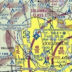
| Sectional chart |
|---|
|
 Download PDF
of official airport diagram from the FAA
| Airport distance calculator |
|---|
|
|
| Sunrise and sunset |
|---|
|
Times for 13-Dec-2025
| | Local
(UTC-5) | | Zulu
(UTC) |
|---|
| Morning civil twilight | | 07:16 | | 12:16 |
| Sunrise | | 07:47 | | 12:47 |
| Sunset | | 17:06 | | 22:06 |
| Evening civil twilight | | 17:37 | | 22:37 |
|
| Current date and time |
|---|
| Zulu (UTC) | 13-Dec-2025 08:07:21 |
|---|
| Local (UTC-5) | 13-Dec-2025 03:07:21 |
|---|
|
| METAR |
|---|
| KOSU | 130353Z 23005KT 10SM OVC022 M01/M04 A3006
|
KCMH
10nm SE | 130751Z 25012G18KT 10SM OVC017 01/M03 A3005 RMK AO2 SLP184 T00061033
|
KTZR
12nm S | 130755Z AUTO 25009G14KT 10SM OVC016 00/M03 A3005 RMK AO2 T00001030
|
KDLZ
12nm N | 130755Z AUTO 27006KT 10SM OVC015 M01/M03 A3002 RMK AO2
|
KMRT
15nm NW | 130755Z AUTO 27010KT 10SM OVC014 M01/M04 A3003 RMK AO2 T10091037
|
KLCK
17nm SE | 130755Z AUTO 26008KT 10SM OVC017 00/M02 A3006 RMK AO2 T00031021
|
KUYF
20nm SW | 130755Z AUTO 25015KT 10SM OVC014 00/M02 A3004 RMK AO2
|
|
| TAF |
|---|
KCMH
10nm SE | 130529Z 1306/1406 22006KT P6SM OVC022 FM130700 26008KT P6SM OVC018 PROB30 1317/1319 3SM -SN FM131900 27008KT 1SM -SN OVC012 FM132100 31010KT 1/2SM SN OVC008 FM140300 31010KT 1SM -SN OVC013 FM140400 31012KT 2SM -SN BR OVC013
|
KLCK
17nm SE | 130529Z 1306/1406 22006KT P6SM OVC022 FM130700 26008KT P6SM OVC018 PROB30 1317/1319 3SM -SN FM131900 27008KT 1SM -SN OVC012 FM132100 31010KT 1/2SM SN OVC008 FM140300 31010KT 1SM -SN OVC013 FM140400 31012KT 2SM -SN BR OVC013
|
|
| NOTAMs |
|---|
NOTAMs are issued by the DoD/FAA and will open in a separate window not controlled by AirNav.
|
|


