FAA INFORMATION EFFECTIVE 14 MAY 2026
Location
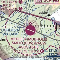
| FAA Identifier: | CDV |
| Lat/Long: | 60-29-29.9030N 145-28-39.2080W
60-29.498383N 145-28.653467W
60.4916397,-145.4775578
(estimated) |
| Elevation: | 53 ft. / 16.2 m (surveyed) |
| Variation: | 19E (2015) |
| From city: | 11 miles SE of CORDOVA, AK |
| Time zone: | UTC -8 (UTC -9 during Standard Time) |
| Zip code: | 99574 |
Airport Operations
| Airport use: | Open to the public |
| Activation date: | 01/1949 |
| Control tower: | no |
| ARTCC: | ANCHORAGE CENTER |
| FSS: | JUNEAU FLIGHT SERVICE STATION [907-586-7380] |
| NOTAMs facility: | CDV (NOTAM-D service available) |
| Attendance: | 0600-1630 |
| Wind indicator: | lighted |
| Segmented circle: | yes |
| Lights: | ACTVT MALSR RWY 27; ODALS RWY 09; VASI RWYS 09 & 27; HIRL RWY 09/27 - CTAF. |
| Beacon: | white-green (lighted land airport)
Operates sunset to sunrise. |
| Fire and rescue: | ARFF index B |
| Airline operations: | CLSD TO ACR OPS MORE THAN 30 PAX SEATS EXC 24 HR PPR IN WRITING - AMGR BOX 598 CORDOVA AK 99574. |
Airport Communications
| CTAF: | 123.6 |
| WX ASOS: | 134.8 (907-424-5900) |
- APCH/DEP SVC PRVDD BY ANCHORAGE ARTCC ON FREQ 133.6/269.4 (MIDDLETON ISLAND RCAG) AND 119.3 (JOHNSTONE POINT RCAG).
- COMMUNICATIONS PRVDD BY JUNEAU FSS ON FREQS 122.2 & 123.6 (CORDOVA RCO).
Nearby radio navigation aids
| VOR radial/distance | | VOR name | | Freq | | Var |
|---|
| JOHr071/33.2 | | JOHNSTONE POINT VOR/DME | | 116.70 | | 18E |
| NDB name | | Hdg/Dist | | Freq | | Var | | ID |
|---|
| GLACIER RIVER | | at field | | 404 | | 17E | | GCR | --. -.-. .-. |
| ORCA BAY | | 071/32.8 | | 233 | | 18E | | ALJ | .- .-.. .--- |
Airport Services
Runway Information
Runway 9/27
| Dimensions: | 7500 x 150 ft. / 2286 x 46 m |
| Surface: | asphalt/grooved, in good condition |
| Weight bearing capacity: | | Single wheel: | 90.0 | | Double wheel: | 153.0 | | Double tandem: | 280.0 |
|
| Runway edge lights: | high intensity |
| RUNWAY 9 | | RUNWAY 27 |
| Latitude: | 60-29.802663N | | 60-29.297485N |
| Longitude: | 145-29.804827W | | 145-27.529395W |
| Elevation: | 41.6 ft. | | 43.0 ft. |
| Traffic pattern: | right | | left |
| Runway heading: | 095 magnetic, 114 true | | 275 magnetic, 294 true |
| Declared distances: | TORA:7500 TODA:7500 ASDA:7500 LDA:7500 | | TORA:7500 TODA:7500 ASDA:7500 LDA:7500 |
| Markings: | precision, in fair condition | | precision, in fair condition |
| Visual slope indicator: | 4-box VASI on left (3.00 degrees glide path)
RWY 09 VASI UNUSBL BYD 4 NM DUE TO OBSTS. | | 4-box VASI on left (3.00 degrees glide path) |
| RVR equipment: | touchdown, rollout | | touchdown, rollout |
| Approach lights: | ODALS: omnidirectional approach lighting system | | MALSR: 1,400 foot medium intensity approach lighting system with runway alignment indicator lights |
| Runway end identifier lights: | no | | |
| Touchdown point: | yes, no lights | | yes, no lights |
| Instrument approach: | | | ILS/DME |
| Obstructions: | 20 ft. ant, lighted, 600 ft. from runway, 250 ft. left of centerline, 20:1 slope to clear | | 25 ft. pole, lighted, 500 ft. from runway, 450 ft. right of centerline, 12:1 slope to clear |
Runway 16/34
| Dimensions: | 1934 x 30 ft. / 589 x 9 m |
| Surface: | gravel, in fair condition |
| Runway edge markings: | 36 IN ORANGE CONES MAY 1 - OCT 25. |
| Operational restrictions: | RWY 16/34 NOT AVBL FOR PART 121/380 SKED AND NON-SKED OPS WITH PAX CARRYING OPS MORE THAN 30 PAX SEATS. |
| RUNWAY 16 | | RUNWAY 34 |
| Latitude: | 60-29.456442N | | 60-29.138950N |
| Longitude: | 145-28.597522W | | 145-28.604830W |
| Elevation: | 49.5 ft. | | 38.6 ft. |
| Traffic pattern: | left | | left |
| Runway heading: | 162 magnetic, 181 true | | 342 magnetic, 001 true |
| Markings: | none, in poor condition | | none, in poor condition |
| Touchdown point: | yes, no lights | | yes, no lights |
| Obstructions: | none | | 70 ft. trees, 350 ft. from runway, 150 ft. left of centerline, 5:1 slope to clear |
Airport Ownership and Management from official FAA records
| Ownership: | Publicly-owned |
| Owner: | ALASKA DOT&PF NORTHERN REGION
2301 PEGER ROAD
FAIRBANKS, AK 99709
Phone 907-451-2200 |
| Manager: | MATTHEW MYSZKA
BOX 598
CORDOVA, AK 99574
Phone 907-424-3202 |
Additional Remarks
| A39-09/27 | PCR VALUE: 977/F/A/X/T |
| E60-27 | ENGINEERED MATERIALS ARRESTING SYSTEM (EMAS) 250 FT IN LENGTH BY 170 FT IN WIDTH LCTD DER 27. |
| - | ERRATIC WINDS. |
| - | ARPT SAND LRGR GRADATION THAN FAA RCMDD/SEE AC150/5200-30. |
| - | WX CAMERA AVBL ON INTERNET AT HTTPS://WEATHERCAMS.FAA.GOV |
| - | TSA REGULATED ARPT; SEE 49 CFR 1542. GATES & DOORS MUST BE SECURED ALL TIMES; INFO - AMGR. |
| - | ARPT SVCS & COND RPTG AVBL ONLY DURG MAINT DUTY HR; AFT HR - AMGR. BTN 1600 & 0700 SNOW REMOVAL & DEICE NA. RWY COND RPT REFLECTS DAY OPS ONLY. |
| - | MOOSE & BIRDS INVOF ARPT & RWYS. |
| - | ARFF EQUIP DURG ACR ACT ONLY. |
| - | CORDOVA WX - 424-7614 OR 122.65. |
Instrument Procedures
NOTE: All procedures below are presented as PDF files. If you need a reader for these files, you should download the free Adobe Reader.NOT FOR NAVIGATION. Please procure official charts for flight.
FAA instrument procedures published for use from 14 May 2026 at 0901Z to 11 June 2026 at 0900Z.
IAPs - Instrument Approach Procedures |
|---|
| ILS OR LOC RWY 27 | |
download (427KB) |
| RNAV (GPS) RWY 27 | |
download (345KB) |
| RNAV (GPS)-B | |
download (268KB) |
| NOTE: Special Alternate Minimums apply | |
download (173KB) |
Departure Procedures |
|---|
| CASEL SEVEN | |
download (168KB) |
| EYAKS SIX | |
download (160KB) |
| NOTE: Special Take-Off Minimums/Departure Procedures apply | |
download (434KB) |
Other nearby airports with instrument procedures:
PAKA - Tatitlek Airport (42 nm NW)
PAVD - Valdez Pioneer Field Airport (45 nm NW)
PAMD - Middleton Island Airport (67 nm S)
|
|

Road maps at:
MapQuest
Bing
Google
| Aerial photo |
|---|
WARNING: Photo may not be current or correct
 Photo courtesy of Dubois Aviation
Photo taken 11-Jul-2012
looking east.
Photo courtesy of Dubois Aviation
Photo taken 11-Jul-2012
looking east.
Do you have a better or more recent aerial photo of Merle K (Mudhole) Smith Airport that you would like to share? If so, please send us your photo.
|
| Sectional chart |
|---|
|
| Airport distance calculator |
|---|
|
|
| Sunrise and sunset |
|---|
|
Times for 31-May-2026
| | Local
(UTC-8) | | Zulu
(UTC) |
|---|
| Morning civil twilight | | 02:59 | | 10:59 |
| Sunrise | | 04:28 | | 12:28 |
| Sunset | | 22:51 | | 06:51 |
| Evening civil twilight | | 00:20 | | 08:20 |
|
| Current date and time |
|---|
| Zulu (UTC) | 31-May-2026 08:02:49 |
|---|
| Local (UTC-8) | 31-May-2026 00:02:49 |
|---|
|
| METAR |
|---|
| PACV | 310753Z 00000KT 10SM BKN026 OVC034 06/05 A3026 RMK AO2 SLP248 T00560050 $
|
|
| TAF |
|---|
| PACV | 310527Z 3106/0106 VRB03KT P6SM VCSH SCT025 BKN035 TEMPO 3106/3110 -SHRA BKN025 FM312100 11008KT P6SM VCSH SCT025 OVC035
|
|
| NOTAMs |
|---|
NOTAMs are issued by the DoD/FAA and will open in a separate window not controlled by AirNav.
|
|

