FAA INFORMATION EFFECTIVE 14 MAY 2026
Location
| FAA Identifier: | AFM |
| Lat/Long: | 67-06-22.3220N 157-51-25.7610W
67-06.372033N 157-51.429350W
67.1062006,-157.8571558
(estimated) |
| Elevation: | 292.6 ft. / 89.2 m (surveyed) |
| Variation: | 13E (2020) |
| From city: | 1 mile N of AMBLER, AK |
| Time zone: | UTC -8 (UTC -9 during Standard Time) |
| Zip code: | 99786 |
Airport Operations
| Airport use: | Open to the public |
| Control tower: | no |
| ARTCC: | ANCHORAGE CENTER |
| FSS: | KOTZEBUE FLIGHT SERVICE STATION [907-442-3310] |
| Alternate FSS: | FAI FAIRBANKS FLIGHT SERVICE STATION [1-866-248-6516] |
| NOTAMs facility: | AFM (NOTAM-D service available) |
| Attendance: | UNATNDD |
| Wind indicator: | lighted |
| Segmented circle: | yes |
| Lights: | ACTVT PAPI RWY 01; MIRL RWY 01/19 & 10/28; WINDSOCK LIGHTS - CTAF. |
| Beacon: | white-green (lighted land airport)
ACTVT ROTG BCN - CTAF. |
Airport Communications
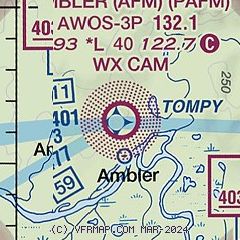
| CTAF: | 122.7 |
| WX AWOS-3P: | 132.1 (907-621-7610) |
- APCH/DEP SVC PRVDD BY ANCHORAGE ARTCC FREQS 119.2/263.0 (KOTZEBUE RCAG).
- COMMUNICATIONS PRVDD BY KOTZEBUE FSS ON FREQ 122.0 (AMBLER RCO).
Airport Services
| Airframe service: | NONE |
| Powerplant service: | NONE |
| Bottled oxygen: | NONE |
| Bulk oxygen: | NONE |
Runway Information
Runway 1/19
| Dimensions: | 4000 x 75 ft. / 1219 x 23 m |
| Surface: | gravel/dirt, in good condition
RWY SURFACE IS COMPACTED GRAVEL, ROCK AND DIRT. SURFACE TYPE LISTED AS GRAVEL-DIRT. |
| Runway edge lights: | medium intensity |
| Operational restrictions: | CROWNS IN CENTER & NO LINE OF SIGHT BTW RWY ENDS. |
| RUNWAY 1 | | RUNWAY 19 |
| Latitude: | 67-05.997643N | | 67-06.603247N |
| Longitude: | 157-51.641085W | | 157-50.994147W |
| Elevation: | 248.5 ft. | | 268.3 ft. |
| Traffic pattern: | left | | left |
| Runway heading: | 010 magnetic, 023 true | | 190 magnetic, 203 true |
| Markings: | nonprecision, in fair condition | | nonprecision, in fair condition |
| Visual slope indicator: | 4-light PAPI on right (3.00 degrees glide path) | | |
| Touchdown point: | yes, no lights | | yes, no lights |
| Obstructions: | 10 ft. trees, 315 ft. from runway, 140 ft. right of centerline, 31:1 slope to clear | | 13 ft. trees, 180 ft. right of centerline |
Runway 10/28
| Dimensions: | 2400 x 60 ft. / 732 x 18 m |
| Surface: | gravel/dirt, in good condition
RWY SURFACE IS COMPACTED GRAVEL, ROCK AND DIRT. SURFACE TYPE LISTED AS GRAVEL-DIRT. |
| Runway edge lights: | medium intensity |
| Operational restrictions: | RWY SLOPES UPHILL EAST TO WEST APPX 80 FT. |
| RUNWAY 10 | | RUNWAY 28 |
| Latitude: | 67-06.566893N | | 67-06.415753N |
| Longitude: | 157-52.082102W | | 157-51.148908W |
| Elevation: | 292.6 ft. | | 267.3 ft. |
| Traffic pattern: | left | | left |
| Runway heading: | 100 magnetic, 113 true | | 280 magnetic, 293 true |
| Markings: | basic, in fair condition | | basic, in fair condition |
| Touchdown point: | yes, no lights | | yes, no lights |
Airport Ownership and Management from official FAA records
| Ownership: | Publicly-owned |
| Owner: | ALASKA DOT&PF NORTHERN REGION
2301 PEGER ROAD
FAIRBANKS, AK 99709
Phone 907-451-2200 |
| Manager: | ALVIN WERNEKE
BOX 55
KOTZEBUE, AK 99752
Phone 907-442-3147 |
Additional Remarks
| - | CARIBOU INVOF RY. |
| - | RY CONDITIONS NOT MONITORED; RECOMMEND VISUAL INSPECTION PRIOR TO LANDING. |
| - | WX CAMERA AVBL ON INTERNET AT HTTPS://WEATHERCAMS.FAA.GOV |
| - | COLD TEMPERATURE AIRPORT. ALTITUDE CORRECTION REQUIRED AT OR BELOW -36C. |
Instrument Procedures
NOTE: All procedures below are presented as PDF files. If you need a reader for these files, you should download the free Adobe Reader.NOT FOR NAVIGATION. Please procure official charts for flight.
FAA instrument procedures published for use from 14 May 2026 at 0901Z to 11 June 2026 at 0900Z.
IAPs - Instrument Approach Procedures |
|---|
| RNAV (GPS) RWY 01 | |
download (260KB) |
| NOTE: Special Alternate Minimums apply | |
download (46KB) |
| NOTE: Special Take-Off Minimums/Departure Procedures apply | |
download (399KB) |
Other nearby airports with instrument procedures:
PAGH - Shungnak Airport (21 nm SE)
PAOB - Kobuk Airport (25 nm SE)
PASK - Selawik Airport (59 nm SW)
PAIK - Bob Baker Memorial Airport (61 nm W)
PFNO - Robert (Bob) Curtis Memorial Airport (76 nm W)
|
|

Road maps at:
MapQuest
Bing
Google
| Aerial photo |
|---|

|
| Sectional chart |
|---|
|
| Airport distance calculator |
|---|
|
|
| Sunrise and sunset |
|---|
|
Times for 07-Jun-2026
| | Local
(UTC-8) | | Zulu
(UTC) |
|---|
| Morning civil twilight | | + | | + |
| Sunrise | | + | | + |
| Sunset | | + | | + |
| Evening civil twilight | | + | | + |
|
| Current date and time |
|---|
| Zulu (UTC) | 07-Jun-2026 16:05:18 |
|---|
| Local (UTC-8) | 07-Jun-2026 08:05:18 |
|---|
|
| METAR |
|---|
| PAFM | 071556Z AUTO 15003KT 8SM SCT007 BKN045 OVC060 02/00 A2953 RMK AO2 SLP006 T00170000 FZRANO $
|
|
| NOTAMs |
|---|
NOTAMs are issued by the DoD/FAA and will open in a separate window not controlled by AirNav.
|
|

