FAA INFORMATION EFFECTIVE 10 JULY 2025
Location
| FAA Identifier: | GKN |
| Lat/Long: | 62-09-15.6050N 145-27-19.0500W
62-09.260083N 145-27.317500W
62.1543347,-145.4552917
(estimated) |
| Elevation: | 1586.1 ft. / 483.4 m (surveyed) |
| Variation: | 17E (2020) |
| From city: | 4 miles NE of GULKANA, AK
(LCTD 4 SM NE OF GLENNALLEN.) |
| Time zone: | UTC -8 (UTC -9 during Standard Time) |
| Zip code: | 99588 |
Airport Operations
| Airport use: | Open to the public |
| Activation date: | 07/1947 |
| Control tower: | no |
| ARTCC: | ANCHORAGE CENTER |
| FSS: | KENAI FLIGHT SERVICE STATION [907-283-7211] |
| NOTAMs facility: | GKN (NOTAM-D service available) |
| Attendance: | JUN-SEP MON-FRI 0900-1700, OCT-MAY MON-FRI 1000-1500 |
| Wind indicator: | lighted |
| Segmented circle: | yes |
| Lights: | ACTVT VASI RWY 15L & 33R; MIRL RWY 15L/33R - CTAF. |
| Beacon: | white-green (lighted land airport)
Operates sunset to sunrise. |
Airport Communications
| CTAF: | 122.9 |
| WX ASOS: | 134.85 (907-822-3707) |
- APCH/DEP SVC PRVDD BY ANCHORAGE ARTCC ON FREQS 119.5/317.5 (GULKANA RCAG).
Nearby radio navigation aids
| VOR radial/distance | | VOR name | | Freq | | Var |
|---|
| GKN at field | | GULKANA VOR/DME | | 115.60 | | 17E |
Airport Services
| Fuel available: | 100LL JET-A
100LL:FUEL AVBL 24 HRS WITH CREDIT CARD OR CALL 907-822-4331. |
| Parking: | tiedowns |
| Airframe service: | MINOR |
| Powerplant service: | MINOR |
| Bottled oxygen: | NONE |
| Bulk oxygen: | NONE |
Runway Information
Runway 15L/33R
| Dimensions: | 5001 x 100 ft. / 1524 x 30 m |
| Surface: | asphalt, in good condition |
| Runway edge lights: | medium intensity |
| RUNWAY 15L | | RUNWAY 33R |
| Latitude: | 62-09.702450N | | 62-08.891763N |
| Longitude: | 145-27.396795W | | 145-27.123533W |
| Elevation: | 1586.1 ft. | | 1546.0 ft. |
| Traffic pattern: | left | | left |
| Runway heading: | 154 magnetic, 171 true | | 334 magnetic, 351 true |
| Markings: | nonprecision, in good condition | | nonprecision, in good condition |
| Visual slope indicator: | 4-box VASI on left (3.00 degrees glide path) | | 4-box VASI on right (3.00 degrees glide path) |
| Touchdown point: | yes, no lights | | yes, no lights |
| Obstructions: | 37 ft. trees, 1500 ft. from runway, 171 ft. left of centerline, 35:1 slope to clear | | 57 ft. trees, 1914 ft. from runway, 30:1 slope to clear
BRUSH 6 FT HIGH, 190 FT OFF RUNWAY END, 90 FT RIGHT. |
Runway 15R/33L
| Dimensions: | 2300 x 60 ft. / 701 x 18 m |
| Surface: | gravel, in good condition |
| RUNWAY 15R | | RUNWAY 33L |
| Latitude: | 62-09.366000N | | 62-08.993167N |
| Longitude: | 145-27.505167W | | 145-27.379333W |
| Elevation: | 1567.9 ft. | | 1547.4 ft. |
| Traffic pattern: | left | | left |
| Runway heading: | 154 magnetic, 171 true | | 334 magnetic, 351 true |
| Markings: | none, in good condition | | none, in good condition |
| Touchdown point: | yes, no lights | | yes, no lights |
| Obstructions: | 56 ft. tower, lighted, 880 ft. from runway, 45 ft. right of centerline, 15:1 slope to clear | | 63 ft. trees, 1213 ft. from runway, 69 ft. right of centerline, 19:1 slope to clear |
Airport Ownership and Management from official FAA records
| Ownership: | Publicly-owned |
| Owner: | ALASKA DOT&PF NORTHERN REGION
, 2301 PEGER RD
FAIRBANKS, AK 99701
Phone 907-451-2200 |
| Manager: | CHAD HELLER
BOX 7
GLENNALLEN, AK 99588
Phone 907-822-3222 |
Additional Remarks
| - | MIGRATORY BIRDS ON & INVOF ARPT DURING SPRING. |
| - | SUAIS 125.3/126.3 (1-800-758-8723). |
| - | RWY 15R/33L IS MAINTAINED AS SKI STRIP IN WINTER AND GRVL STRIP THE REMAINDER OF THE YEAR. VISUAL INSPECTION REQD BEFORE LNDG. BEACON TWR AND OTHER OBSTACLES ON N APCH END. |
| - | MOOSE & CARIBOU ON & AROUND ARPT. |
| - | PERSONNEL AND EQUIPMENT MAY BE WORKING ON RWY AT ANY TIME. |
| - | RWY CONDITION NOT MONITORED; RECOMMEND VISUAL INSPECTION PRIOR TO LANDING. |
| - | WX CAMERA AVBL ON INTERNET AT HTTPS://WEATHERCAMS.FAA.GOV |
Instrument Procedures
NOTE: All procedures below are presented as PDF files. If you need a reader for these files, you should download the free Adobe Reader.NOT FOR NAVIGATION. Please procure official charts for flight.
FAA instrument procedures published for use from 10 July 2025 at 0901Z to 07 August 2025 at 0900z.
IAPs - Instrument Approach Procedures |
|---|
| RNAV (GPS) RWY 15L | |
download (251KB) |
| RNAV (GPS) RWY 33R | |
download (378KB) |
| VOR RWY 15L | |
download (207KB) |
| VOR-A | |
download (206KB) |
| NOTE: Special Take-Off Minimums/Departure Procedures apply | |
download (405KB) |
Other nearby airports with instrument procedures:
PAVD - Valdez Pioneer Field Airport (65 nm S)
PAKA - Tatitlek Airport (85 nm SW)
PFTO - Tok Junction Airport (98 nm NE)
|
|

Road maps at:
MapQuest
Bing
Google
| Aerial photo |
|---|
WARNING: Photo may not be current or correct

Do you have a better or more recent aerial photo of Gulkana Airport that you would like to share? If so, please send us your photo.
|
| Sectional chart |
|---|
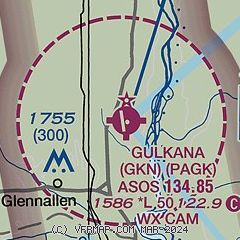
|
| Airport distance calculator |
|---|
|
|
| Sunrise and sunset |
|---|
|
Times for 15-Jul-2025
| | Local
(UTC-8) | | Zulu
(UTC) |
|---|
| Morning civil twilight | | 02:28 | | 10:28 |
| Sunrise | | 04:24 | | 12:24 |
| Sunset | | 23:11 | | 07:11 |
| Evening civil twilight | | 01:07 | | 09:07 |
|
| Current date and time |
|---|
| Zulu (UTC) | 15-Jul-2025 15:17:33 |
|---|
| Local (UTC-8) | 15-Jul-2025 07:17:33 |
|---|
|
| METAR |
|---|
| PAGK | 151453Z AUTO 00000KT 10SM -RA OVC060 10/08 A3041 RMK AO2 RAB34 SLP300 P0001 60001 T01000083 50002 TSNO
|
|
| TAF |
|---|
| PAGK | 151122Z 1512/1612 VRB05KT P6SM VCSH SCT040 BKN060 FM152200 16006KT P6SM SCT140
|
|
| NOTAMs |
|---|
NOTAMs are issued by the DoD/FAA and will open in a separate window not controlled by AirNav.
|
|


