FAA INFORMATION EFFECTIVE 14 MAY 2026
Location
| FAA Identifier: | ANC |
| Lat/Long: | 61-10-26.7050N 149-59-53.2950W
61-10.445083N 149-59.888250W
61.1740847,-149.9981375
(estimated) |
| Elevation: | 151.4 ft. / 46.1 m (surveyed) |
| Variation: | 16E (2020) |
| From city: | 4 miles SW of ANCHORAGE, AK |
| Time zone: | UTC -8 (UTC -9 during Standard Time) |
| Zip code: | 99502 |
Airport Operations
| Airport use: | Open to the public |
| Activation date: | 11/1951 |
| Control tower: | yes |
| ARTCC: | ANCHORAGE CENTER |
| FSS: | KENAI FLIGHT SERVICE STATION [907-283-7211] |
| NOTAMs facility: | ANC (NOTAM-D service available) |
| Attendance: | CONTINUOUS |
| Wind indicator: | lighted |
| Segmented circle: | no |
| Beacon: | white-green (lighted land airport)
Operates sunset to sunrise. |
| Landing fee: | yes |
| Fire and rescue: | ARFF index E |
| International operations: | customs landing rights airport |
Airport Communications
| UNICOM: | 122.95 |
| WX ASOS: | PHONE 907-271-5278 |
| ANCHORAGE GROUND: | 121.9 338.25 |
| ANCHORAGE TOWER: | 118.3 257.8 |
| ANCHORAGE APPROACH: | 118.6 ;250-330 TED ABV 1500 FT 118.6 ;331-045 TED ABV 2500 FT 119.1 ;250-330 TED 1500 FT & BLW 119.1 ;331-045 TED 2500 FT & BLW 123.8 ;206-249 TED 126.4 ;046-205 TED 134.1 |
| ANCHORAGE DEPARTURE: | 118.6 ;250-330 TED ABV 1500 FT 118.6 ;331-045 TED ABV 2500 FT 119.1 ;250-330 TED 1500 FT & BLW 119.1 ;331-045 TED 2500 FT & BLW 123.8 ;206-249 TED 126.4 ;046-205 TED |
| CLEARANCE DELIVERY: | 119.4 323.1 128.65 |
| AMOTT STAR: | 126.4 |
| CLASS C: | 118.6 ;250-330 TED ABV 1500 FT 118.6 ;331-045 TED ABV 2500 FT 119.1 ;250-330 TED 1500 FT & BLW 119.1 ;331-045 TED 2500 FT & BLW 123.8 ;206-249 TED 126.4 ;046-205 TED |
| D-ATIS: | 135.5 |
| EMERG: | 121.5 243.0 |
| IC: | 118.6 ;331-045 TED ABV 2500 FT |
| NEELL STAR: | 126.4 |
| POTTER DP: | 126.4 |
| TURNAGAIN DP: | 126.4 |
| YESKA STAR: | 126.4 |
| WX ASOS at LHD (1.2 nm NE): | 125.6 (907-245-5432) |
| WX ASOS at MRI (5 nm NE): | 124.25 (907-271-5277) |
| WX ASOS at FRN (11 nm NE): | 134.25 |
- ASSC IN USE. OPERATE TRANSPONDERS WITH ALTITUDE REPORTING MODE AND ADS-B (IF EQUIPPED) ENABLED ON ALL AIRPORT SURFACES.
Nearby radio navigation aids
| VOR radial/distance | | VOR name | | Freq | | Var |
|---|
| TEDr271/1.2 | | ANCHORAGE VOR/DME | | 113.15 | | 18E |
| BGQr163/23.7 | | BIG LAKE VORTAC | | 112.50 | | 19E |
Airport Services
| Fuel available: | 100 100LL JET-A JET-A1 |
| Parking: | hangars and tiedowns |
| Airframe service: | MAJOR |
| Powerplant service: | MAJOR |
| Bottled oxygen: | HIGH/LOW |
| Bulk oxygen: | HIGH/LOW |
Runway Information
Runway 7R/25L
| Dimensions: | 12400 x 200 ft. / 3780 x 61 m |
| Surface: | asphalt/concrete/grooved, in good condition |
| Weight bearing capacity: | | Single wheel: | 120.0 | | Double wheel: | 250.0 | | Double tandem: | 550.0 | | Dual double tandem: | 1120.0 |
|
| Runway edge lights: | high intensity |
| RUNWAY 7R | | RUNWAY 25L |
| Latitude: | 61-10.068693N | | 61-10.072870N |
| Longitude: | 150-02.572278W | | 149-58.358917W |
| Elevation: | 132.1 ft. | | 100.7 ft. |
| Traffic pattern: | right | | left |
| Runway heading: | 074 magnetic, 090 true | | 254 magnetic, 270 true |
| Declared distances: | TORA:10900 TODA:10900 ASDA:10900 LDA:12400 | | TORA:12400 TODA:12400 ASDA:12000 LDA:12000 |
| Markings: | precision, in good condition | | precision, in good condition |
| Visual slope indicator: | 4-light PAPI on right (3.00 degrees glide path) | | 4-light PAPI on left (3.00 degrees glide path) |
| RVR equipment: | touchdown, midfield, rollout | | touchdown, midfield, rollout |
| Approach lights: | ALSF2: standard 2,400 foot high intensity approach lighting system with centerline sequenced flashers (category II or III) | | |
| Runway end identifier lights: | | | no |
| Centerline lights: | yes | | yes |
| Touchdown point: | yes, lighted | | yes, no lights |
| Instrument approach: | ILS/DME | | |
Runway 15/33
| Dimensions: | 10865 x 200 ft. / 3312 x 61 m |
| Surface: | asphalt/grooved, in good condition |
| Weight bearing capacity: | | Single wheel: | 120.0 | | Double wheel: | 250.0 | | Double tandem: | 550.0 | | Dual double tandem: | 1120.0 |
|
| Runway edge lights: | high intensity |
| RUNWAY 15 | | RUNWAY 33 |
| Latitude: | 61-11.983833N | | 61-10.262500N |
| Longitude: | 150-00.871833W | | 149-59.908167W |
| Elevation: | 151.4 ft. | | 121.8 ft. |
| Traffic pattern: | right | | left |
| Runway heading: | 149 magnetic, 165 true | | 329 magnetic, 345 true |
| Displaced threshold: | no | | 465 ft. |
| Declared distances: | TORA:10865 TODA:10865 ASDA:10000 LDA:10000 | | TORA:10865 TODA:11965 ASDA:10865 LDA:10400 |
| Markings: | precision, in good condition | | precision, in good condition |
| Visual slope indicator: | 4-light PAPI on right (3.20 degrees glide path) | | 4-light PAPI on right (3.00 degrees glide path) |
| RVR equipment: | touchdown, midfield, rollout | | touchdown, midfield, rollout |
| Approach lights: | MALSF: 1,400 foot medium intensity approach lighting system with sequenced flashers | | |
| Runway end identifier lights: | | | yes |
| Centerline lights: | yes | | yes |
| Touchdown point: | yes, no lights | | yes, no lights |
| Instrument approach: | ILS/DME | | |
Runway 7L/25R
| Dimensions: | 10600 x 150 ft. / 3231 x 46 m |
| Surface: | asphalt/grooved, in good condition |
| Weight bearing capacity: | | Single wheel: | 120.0 | | Double wheel: | 250.0 | | Double tandem: | 550.0 | | Dual double tandem: | 1120.0 |
|
| Runway edge lights: | high intensity |
| RUNWAY 7L | | RUNWAY 25R |
| Latitude: | 61-10.185898N | | 61-10.188670N |
| Longitude: | 150-00.499997W | | 149-56.898043W |
| Elevation: | 127.7 ft. | | 91.8 ft. |
| Traffic pattern: | right | | left |
| Runway heading: | 074 magnetic, 090 true | | 254 magnetic, 270 true |
| Declared distances: | TORA:10600 TODA:10600 ASDA:10600 LDA:10600 | | TORA:10600 TODA:10600 ASDA:10600 LDA:10600 |
| Markings: | precision, in good condition | | precision, in good condition |
| Visual slope indicator: | 4-light PAPI on right (3.00 degrees glide path) | | 4-light PAPI on left (3.00 degrees glide path) |
| RVR equipment: | touchdown, rollout | | touchdown, rollout |
| Approach lights: | MALSR: 1,400 foot medium intensity approach lighting system with runway alignment indicator lights | | |
| Centerline lights: | yes | | yes |
| Touchdown point: | yes, lighted | | yes, no lights |
| Instrument approach: | ILS/DME | | |
Airport Ownership and Management from official FAA records
| Ownership: | Publicly-owned |
| Owner: | STATE OF ALASKA DOTPF
BOX 196960
ANCHORAGE, AK 99519-6960
Phone 907-266-2600 |
| Manager: | AARON DANIELSON
BOX 196960
ANCHORAGE, AK 99519-6960
Phone 907-266-2545 |
Additional Remarks
| A39-07R/25L | PCR VALUE: 663/F/A/W/T |
| A39-07L/25R | PCR VALUE: 663/F/A/W/T |
| A39-15/33 | PCR VALUE: 663/F/A/W/T |
| A30A-25L | 200 FT BLAST PAD. |
| A30A-07R | BACK TAX FM TWY J FOR DEP NA. |
| - | BIRDS INVOF ARPT SPRING - FALL. |
| - | 489 FT UNLGTD TWR 2.5 MI NE. |
| - | NON-RADIO NIGHT OPS NA; NON-PARROT OPS 1 HR PPR; NON-RADIO OPS PPR; MUST PRVD ETA & REMAIN WI 15 MIN - ATCT 907-271-2700 WKDAYS 0730-1600; AFT HR & HOL - FAA 907-271-5936. |
| - | PTNS OF TWY K BTN TWY H & J NOT VIS FM ATCT. |
| - | COMPASS CLBR PAD N/A. |
| - | R TURN OUT OF RAMP PRKG R-2 THRU R-4 NA. |
| - | FLT PLANNING IN ANCHORAGE BOWL AREA - RCO 122.55. |
| - | FAA RAMP PPR WITH ANC FIFO MON-FRI 0600-1430 - 135.85 OR 907-271-2414 OR AVN 405-954-9780. |
| - | ANCHORAGE WX CAMERA AVBL ON INTERNET AT HTTPS://WEATHERCAMS.FAA.GOV. |
| - | TWY V RSTRD TO 12500 LB OR LESS; SUBJECT TO JET BLAST W OF TWY E. |
| - | TSNT MIL PPR. |
| - | NOISE SENSITIVE AREA S & E; RWY 07R, 07L, 15 TBJT/TURBOFAN DEP EMPLOY FAA CLOSE IN NADP OR ICAO PROC B NADP WHEN SAFETY PERMITS; INFO - AMGR. |
| - | TWY V, SCTY GATE E OF TWY E - PCL 121.75 5 TIMES; TWY H-2, LAKESHORE TWY GATES - PCL 121.75 3 TIMES; IF INOP ALLOW 30 SEC RESET & NOTIFY LHD OPS - 907-266-2600. |
| - | PPR FOR GND TIME GTR THAN 4 HR AT ARPT CTL SPOTS; APVL REQ 48 HR PRIOR TO DEP FOR ANC - GATE MGMT 907 266-2633 OR EMAIL: DOT.AIA.OPS.GATEMANAGEMENT@ALASKA.GOV. |
| - | P RAMP PRKG SPOTS P1/2/3 JET BLAST HAZ; EXIT USING MIN THRUST REQ. |
| - | COLD TEMPERATURE AIRPORT. ALTITUDE CORRECTION REQUIRED AT OR BELOW -21C. |
| - | WSO - 907-266-5105. |
Instrument Procedures
NOTE: All procedures below are presented as PDF files. If you need a reader for these files, you should download the free Adobe Reader.NOT FOR NAVIGATION. Please procure official charts for flight.
FAA instrument procedures published for use from 14 May 2026 at 0901Z to 11 June 2026 at 0900Z.
STARs - Standard Terminal Arrivals |
|---|
| AMOTT FOUR | |
2 pages:
[1] [2] (306KB) |
| ELLAM FIVE | |
download (132KB) |
| KROTO FIVE (RNAV) | |
download (248KB) |
| NEELL SEVEN (RNAV) | |
2 pages:
[1] [2] (353KB) |
| PTERS THREE (RNAV) | |
download (242KB) |
| TAGER NINE | |
download (222KB) |
| WITTI FIVE (RNAV) | |
download (235KB) |
| YESKA SIX | |
download (149KB) |
IAPs - Instrument Approach Procedures |
|---|
| ILS OR LOC RWY 07L **CHANGED** | |
download (342KB) |
| ILS OR LOC RWY 07R **CHANGED** | |
download (385KB) |
| ILS RWY 15 **CHANGED** | |
download (562KB) |
| ILS RWY 07R (SA CAT I) **CHANGED** | |
download (340KB) |
| ILS RWY 07L (SA CAT I - II) **CHANGED** | |
download (335KB) |
| ILS RWY 07R (CAT II - III) **CHANGED** | |
download (353KB) |
| RNAV (RNP) RWY 33 **CHANGED** | |
download (249KB) |
| RNAV (RNP) Z RWY 07R **CHANGED** | |
download (248KB) |
| RNAV (GPS) RWY 07L **CHANGED** | |
download (271KB) |
| RNAV (GPS) RWY 15 **CHANGED** | |
download (306KB) |
| RNAV (GPS) Y RWY 07R **CHANGED** | |
download (262KB) |
| HIGHWAY VISUAL RWY 25R | |
download (174KB) |
| SEWARD VISUAL RWY 25L | |
download (175KB) |
| NOTE: Special Alternate Minimums apply | |
download (173KB) |
Departure Procedures |
|---|
| ANCHORAGE ONE | |
download (210KB) |
| FFITZ FOUR (RNAV) | |
download (195KB) |
| KNIK THREE | |
download (174KB) |
| NOEND FOUR (RNAV) | |
download (203KB) |
| POTTR THREE | |
download (183KB) |
| TURNAGAIN EIGHT | |
download (160KB) |
| NOTE: Special Take-Off Minimums/Departure Procedures apply | |
download (393KB) |
Other nearby airports with instrument procedures:
PAMR - Merrill Field Airport (5 nm NE)
PAED - Elmendorf Air Force Base (7 nm NE)
PAFR - Bryant Army Airfield (11 nm NE)
PAGQ - Big Lake Airport (22 nm N)
PAWS - Wasilla Airport (27 nm NE)
|
|

Road maps at:
MapQuest
Bing
Google
| Aerial photo |
|---|
WARNING: Photo may not be current or correct
 Photo taken 13-Sep-2005
Do you have a better or more recent aerial photo of Ted Stevens Anchorage International Airport that you would like to share? If so, please send us your photo.
|
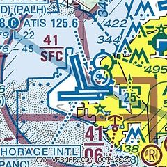
| Sectional chart |
|---|
|
CAUTION: Diagram may not be current
 Download PDF
of official airport diagram from the FAA
| Airport distance calculator |
|---|
|
|
| Sunrise and sunset |
|---|
|
Times for 01-Jun-2026
| | Local
(UTC-8) | | Zulu
(UTC) |
|---|
| Morning civil twilight | | 02:53 | | 10:53 |
| Sunrise | | 04:37 | | 12:37 |
| Sunset | | 23:18 | | 07:18 |
| Evening civil twilight | | 01:02 | | 09:02 |
|
| Current date and time |
|---|
| Zulu (UTC) | 02-Jun-2026 05:55:34 |
|---|
| Local (UTC-8) | 01-Jun-2026 21:55:34 |
|---|
|
| METAR |
|---|
| PANC | 020453Z 16017G28KT 10SM OVC080 11/03 A3031 RMK AO2 PK WND 14028/0447 SLP266 T01060033
|
| PALH | 020453Z 18009G18KT 10SM BKN080 OVC110 12/03 A3032 RMK AO2 SLP268 T01170028
|
PAMR
5nm NE | 020453Z 20004KT 10SM BKN070 OVC090 14/02 A3031 RMK AO2 SLP264 T01440017
|
PAED
7nm NE | 020455Z 12007KT 10SM SCT070 BKN100 14/01 A3031 RMK AO2A SLP260 T01430009 $
|
PAFR
11nm NE | 020523Z AUTO 12013KT 9SM -RA FEW045 OVC065 13/02 A3031 RMK AO2 RAB23 SLP267 $
|
|
| TAF |
|---|
| PANC | 011723Z 0118/0224 32006KT P6SM OVC100 WS020/12025KT FM012200 14012G24KT P6SM BKN100 TEMPO 0122/0202 14018G30KT FM020900 03005KT P6SM BKN100
|
PAED
7nm NE | 012100Z 0121/0303 28012KT 9999 SCT050 BKN100 520303 QNH3028INS BECMG 0213/0214 01006KT 9999 FEW200 QNH3016INS TX20/0221Z TN05/0213Z
|
|
| NOTAMs |
|---|
NOTAMs are issued by the DoD/FAA and will open in a separate window not controlled by AirNav.
|
|


