FAA INFORMATION EFFECTIVE 15 MAY 2025
Location
| FAA Identifier: | PEQ |
| Lat/Long: | 31-22-56.6000N 103-30-38.6000W
31-22.943333N 103-30.643333W
31.3823889,-103.5107222
(estimated) |
| Elevation: | 2613.1 ft. / 796.5 m (surveyed) |
| Variation: | 09E (1995) |
| From city: | 2 miles SW of PECOS, TX |
| Time zone: | UTC -5 (UTC -6 during Standard Time) |
| Zip code: | 79772 |
Airport Operations
| Airport use: | Open to the public |
| Activation date: | 09/1938 |
| Control tower: | no |
| ARTCC: | ALBUQUERQUE CENTER |
| FSS: | SAN ANGELO FLIGHT SERVICE STATION |
| NOTAMs facility: | PEQ (NOTAM-D service available) |
| Attendance: | CONTINUOUS |
| Wind indicator: | lighted |
| Segmented circle: | yes |
| Lights: | MIRL RY 14/32 PRESET LOW INTST; TO INCR INTST & ACTVT MIRL RY 09/27 - CTAF. PAPI RYS 14 & 32 OPERATES CONTINUOUSLY. |
| Beacon: | white-green (lighted land airport)
Operates sunset to sunrise. |
Airport Communications
| CTAF/UNICOM: | 122.8 |
| WX AWOS-3: | 118.175 (432-445-3867) |
- APCH/DEP SVC PRVDD BY ALBUQUERQUE ARTCC (ABQ) ON FREQS 135.875/292.15 (FORT STOCKTON RCAG).
Nearby radio navigation aids
| VOR radial/distance | | VOR name | | Freq | | Var |
|---|
| PEQr137/6.2 | | PECOS VOR/DME | | 116.50 | | 11E |
| INKr194/32.5 | | WINK VORTAC | | 112.10 | | 11E |
| FSTr302/37.7 | | FORT STOCKTON VORTAC | | 116.90 | | 11E |
Airport Services
| Fuel available: | 100LL JET-A1+
100LL:FOR FUEL AFTER HOURS CTC UNICOM 122.8 OR CALL 432-447-2488. |
| Parking: | hangars and tiedowns |
| Airframe service: | MAJOR |
| Powerplant service: | MAJOR |
| Bottled oxygen: | NONE |
| Bulk oxygen: | NONE |
Runway Information
Runway 14/32
| Dimensions: | 6236 x 80 ft. / 1901 x 24 m |
| Surface: | asphalt, in good condition |
| Weight bearing capacity: | | Single wheel: | 25.0 | | Double wheel: | 37.0 |
|
| Runway edge lights: | medium intensity
MIRLS NSTD 20 FT FROM PVMNT EDGE. |
| RUNWAY 14 | | RUNWAY 32 |
| Latitude: | 31-23.492140N | | 31-22.637462N |
| Longitude: | 103-31.022748W | | 103-30.356072W |
| Elevation: | 2608.1 ft. | | 2600.9 ft. |
| Traffic pattern: | left | | left |
| Runway heading: | 137 magnetic, 146 true | | 317 magnetic, 326 true |
| Markings: | nonprecision, in good condition | | nonprecision, in good condition |
| Visual slope indicator: | 2-light PAPI on left (3.00 degrees glide path)
PAPI OTS | | 2-light PAPI on left (3.00 degrees glide path) |
| Touchdown point: | yes, no lights | | yes, no lights |
| Obstructions: | 75 ft. sign, 2514 ft. from runway, 395 ft. left of centerline, 30:1 slope to clear | | none |
Runway 9/27
| Dimensions: | 5953 x 80 ft. / 1814 x 24 m |
| Surface: | asphalt, in good condition |
| Weight bearing capacity: | | Single wheel: | 25.0 | | Double wheel: | 37.0 |
|
| Runway edge lights: | medium intensity |
| RUNWAY 9 | | RUNWAY 27 |
| Latitude: | 31-22.909873N | | 31-22.719135N |
| Longitude: | 103-31.155093W | | 103-30.032500W |
| Elevation: | 2613.0 ft. | | 2597.9 ft. |
| Traffic pattern: | left | | left |
| Runway heading: | 092 magnetic, 101 true | | 272 magnetic, 281 true |
| Markings: | nonprecision, in good condition | | nonprecision, in good condition |
| Touchdown point: | yes, no lights | | yes, no lights |
| Obstructions: | none | | 45 ft. pline, marked, 2020 ft. from runway, 40:1 slope to clear |
Airport Ownership and Management from official FAA records
| Ownership: | Publicly-owned |
| Owner: | CITY OF PECOS
PO BOX 929
PECOS, TX 79772
Phone 432-445-2421 |
| Manager: | COLEY MEANS
3110 MANAHAN STREET
PECOS, TX 79772
Phone (512) 422-6396 |
Additional Remarks
| - | FOR CD IF UNA TO CTC ON FSS FREQ, CTC ALBUQUERQUE ARTCC AT 505-856-4561. |
Instrument Procedures
NOTE: All procedures below are presented as PDF files. If you need a reader for these files, you should download the free Adobe Reader.NOT FOR NAVIGATION. Please procure official charts for flight.
FAA instrument procedures published for use from 15 May 2025 at 0901Z to 13 June 2025 at 0900z.
IAPs - Instrument Approach Procedures |
|---|
| RNAV (GPS) RWY 14 | |
download (257KB) |
| RNAV (GPS) RWY 32 | |
download (256KB) |
| NOTE: Special Alternate Minimums apply | |
download (116KB) |
| NOTE: Special Take-Off Minimums/Departure Procedures apply | |
download (104KB) |
Other nearby airports with instrument procedures:
KINK - Winkler County Airport (29 nm NE)
E01 - Roy Hurd Memorial Airport (33 nm E)
KFST - Fort Stockton-Pecos County Airport (42 nm SE)
E38 - Alpine-Casparis Municipal Airport (61 nm S)
KODO - Odessa Airport-Schlemeyer Field (66 nm NE)
|
|

Road maps at:
MapQuest
Bing
Google
| Aerial photo |
|---|
WARNING: Photo may not be current or correct
 Taken early January 2011
looking north.
Taken early January 2011
looking north.
Do you have a better or more recent aerial photo of Pecos Municipal Airport that you would like to share? If so, please send us your photo.
|
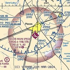
| Sectional chart |
|---|
|
| Airport distance calculator |
|---|
|
|
| Sunrise and sunset |
|---|
|
Times for 17-May-2025
| | Local
(UTC-5) | | Zulu
(UTC) |
|---|
| Morning civil twilight | | 06:31 | | 11:31 |
| Sunrise | | 06:58 | | 11:58 |
| Sunset | | 20:43 | | 01:43 |
| Evening civil twilight | | 21:10 | | 02:10 |
|
| Current date and time |
|---|
| Zulu (UTC) | 17-May-2025 23:35:36 |
|---|
| Local (UTC-5) | 17-May-2025 18:35:36 |
|---|
|
| TAF |
|---|
| KPEQ | 171725Z 1718/1818 25010KT P6SM SCT200 FM172100 23014G22KT P6SM SCT200 FM180100 25007KT P6SM SCT250 AMD NOT SKED
|
|
| NOTAMs |
|---|
NOTAMs are issued by the DoD/FAA and will open in a separate window not controlled by AirNav.
|
|


