FAA INFORMATION EFFECTIVE 14 MAY 2026
Location
| FAA Identifier: | HHI |
| Lat/Long: | 21-28-53.2000N 158-02-16.2000W
21-28.886667N 158-02.270000W
21.4814444,-158.0378333
(estimated) |
| Elevation: | 843.3 ft. / 257.0 m (surveyed) |
| Variation: | 11E (1975) |
| From city: | 1 mile SW of WAHIAWA, HI |
| Time zone: | UTC -10 (year round; does not observe DST) |
| Zip code: | 96786 |
Airport Operations
| Airport use: | Private use. Permission required prior to landing |
| Activation date: | 07/1946 |
| Control tower: | yes |
| ARTCC: | HONOLULU CONTROL FACILITY CENTER |
| FSS: | HONOLULU FLIGHT SERVICE STATION |
| NOTAMs facility: | PHHI (NOTAM-D service available) |
| Attendance: | MON-SAT 24 HOURS/DAY
OT BY NOTAM. |
| Pattern altitude: | SOUTH TFC ONLY. TFC PATTERN ALT ROTARY WING 1500 FT MSL; FIXED WING 2000 FT MSL. |
| Wind indicator: | yes |
| Segmented circle: | no |
| Lights: | ACTVT MIRL RWY 06/24 - CTAF. |
| Beacon: | white-green (lighted land airport)
ROTG BCN 1/8 NM NORTH OF ATCT. Operates sunset to sunrise. |
Airport Communications
| CTAF: | 126.3 |
| WHEELER GROUND: | 121.85 237.5 [OPR 1730-0900Z MON-FRI EXC HOL AND WKEND; OT BY NOTAM.] |
| WHEELER TOWER: | 126.3 235.625 [OPR 1730-0900Z MON-FRI EXC HOL AND WKEND; OT BY NOTAM.] |
| HCF APPROACH APPROACH: | 118.3 |
| HCF APPROACH DEPARTURE: | 118.3 |
| D-ATIS: | 119.675 242.4 |
| EMERG: | 121.5 243.0 |
| FLT FLW: | 239.5 ;LIGHTNING AIC |
| OPS: | 141.65 ;LIGHTNING RADIO 148.5 ;BIRD BATH CONTROL 239.5 ;LIGHTNING RADIO |
| PMSV METRO: | 125.1 |
| WX ASOS at JRF (11 nm S): | 119.8 (808-752-3876) |
| WX ASOS at HNL (12 nm SE): | PHONE 808-807-2538 |
- LIGHTING RADIO FREQ 141.65/239.5 M-F AFTER OPR 1730-0900Z . PINEAPPLE OPR 1730-0900Z M-F.
- 125.1, DSN 315-456-1016/1017, C808-656-1016/1017. ALT CTC 17 OWS, DSN 315-449-8333/7950, C808-449-8333/7950. ALT METRO - 346.6 HICKAM.
Nearby radio navigation aids
| VOR radial/distance | | VOR name | | Freq | | Var |
|---|
| HNLr319/12.0 | | HONOLULU VORTAC | | 114.80 | | 11E |
| CKHr294/22.8 | | KOKO HEAD VORTAC | | 113.90 | | 11E |
| NDB name | | Hdg/Dist | | Freq | | Var | | ID |
|---|
| EWABE | | 353/9.4 | | 242 | | 11E | | HN | .... -. |
Airport Services
| Airframe service: | MINOR |
| Powerplant service: | MINOR |
| Bottled oxygen: | NONE |
| Bulk oxygen: | NONE |
Runway Information
Runway 6/24
| Dimensions: | 5608 x 100 ft. / 1709 x 30 m |
| Surface: | asphalt |
| Weight bearing capacity: | |
| Runway edge lights: | medium intensity |
| RUNWAY 6 | | RUNWAY 24 |
| Latitude: | 21-28.717333N | | 21-29.056833N |
| Longitude: | 158-02.731000W | | 158-01.810333W |
| Elevation: | 819.7 ft. | | 843.3 ft. |
| Traffic pattern: | right | | right |
| Runway heading: | 057 magnetic, 068 true | | 237 magnetic, 248 true |
| Displaced threshold: | 570 ft. | | no |
| Runway end identifier lights: | no | | no |
| Touchdown point: | yes, no lights | | yes, no lights |
Airport Ownership and Management from official FAA records
| Ownership: | U.S. Army |
| Owner: | U S ARMY
WHEELER AAF SCHOFLD BARRACKS
WAHIAWA, HI |
| Manager: | AFLD COMMANDER
WHEELER AAF, SCHOFIELD BARRACKS
WAHIAWA, HI
Phone 808-656-2656 |
Additional Remarks
| - | ALL ACFT ARR FM N AFTER 1800 WILL CROSS ARPT AT 2500 FT ENTER TFC FM THE S. |
| - | EXTREMELY NOISE SENSITIVE AREA; AVOID OVERFLIGHT COMMUNITIES SURROUNDING WHEELER AFB. |
| - | CAUTION - EXTREME CAUTION SWEEPER ON RUNWAY M-F 1500-1700Z. |
| - | CAUTION: USE CTN ON TXY A DUE TO NO TWY EDGE LIGHTS INSTLD. ALL AIRFIELD MARKINGS ARE EXTREMELY FADED ON ALL APNS AND TWYS. |
| - | MISC: AUTO WX OBSN AVBL H24; HUMAN BACKUP AVBL MON-FRI 1700-0900Z. HUMAN WX OBSN VIEW OBSTD BY BLDG W THRU NE (250-060 DEGS). VIS EVAL IS LTD TO 1/6 TO 1/4 MILE IN THIS SECT. WX SVCS OPR MON-FRI 1700-0900Z; 2 HR PN RQRD FOR TIMELY BRIEF. |
| - | NO TSNT FIXED-WING ACFT ON TWY A THRU F. SEE AP3 FOR ADDNL RESTRICTIONS. |
| - | CAUTION: BLUE TWY EDGE REFLECTORS INSTLD ON TWY A NORTH OF RWY AND ON TWY J ADJ TO SOUTH APN. |
| - | SERVICE: FUEL - F24, JAA, 1730-0845Z M-F, OT BY NOTAM. |
| - | WHEELER OPS OPR 1730-0900Z MON-FRI EXC HOL AND WKEND; OT BY NOTAM. |
| - | CAUTION: USE CTN WHEN TAXIING ON TWY A; DO NOT TAXI BHND ACFT IN PSN AND HOLD ON TWY B, C, D, E, F DUE TO RDCD ROTOR/WINGTIP CLNC AVBL. |
| - | LED LGTS INSTLD ON RWY AND ALL TWYS. |
| - | CAUTION: MULT TREE OBSTN HAZARD PENETRATION RWY 24 40:1 APCH CLNC SFC SLOPE OUT TO 6000 FT (EAST SIDE). |
| - | EXTV COPTER TFC INVOF ARPT. |
| - | PRACTICE APCHS BY NON-TENANT ACFT RSTD AND APVD CONTINGENT UPON TENANT ACFT ACTIVITY HRS OF DAY AND ETC. |
| - | PPR FOR FULL STOP LDG, PRKG & FOR NON-TENANT ACFT USE OF WHEELER AAF; CTC OPS C808-771-1282, V456-1282. |
| - | NO TRANSIENT ACFT SVC AVBL. |
| - | NIGHT VISION GOGGLE TRAINING A311 500 FT & BLO FM 1 HR AFTER SS THRU 1 HR BEFORE SR. |
Instrument Procedures
NOTE: All procedures below are presented as PDF files. If you need a reader for these files, you should download the free Adobe Reader.NOT FOR NAVIGATION. Please procure official charts for flight.
FAA instrument procedures published for use from 14 May 2026 at 0901Z to 11 June 2026 at 0900Z.
IAPs - Instrument Approach Procedures |
|---|
| RNAV (GPS)-C | |
download (164KB) |
| VOR OR TACAN-B | |
download (173KB) |
Departure Procedures |
|---|
| GECKO TWO | |
download (82KB) |
| KOKO HEAD TWO | |
download (93KB) |
| NOTE: Special Take-Off Minimums/Departure Procedures apply | |
download (196KB) |
Other nearby airports with instrument procedures:
PHJR - Kalaeloa Airport (John Rodgers Field) (11 nm S)
PHNL - Daniel K Inouye International Airport (12 nm SE)
PHNG - Kaneohe Bay Marine Corps Air Station (Marion E Carl Field) (15 nm E)
PHMK - Molokai Airport (56 nm E)
PHLU - Kalaupapa Airport (62 nm E)
|
|

Road maps at:
MapQuest
Bing
Google
| Aerial photo |
|---|
WARNING: Photo may not be current or correct
 Photo taken 24-Jun-2014
looking southwest.
Photo taken 24-Jun-2014
looking southwest.
Do you have a better or more recent aerial photo of Wheeler Army Airfield that you would like to share? If so, please send us your photo.
|
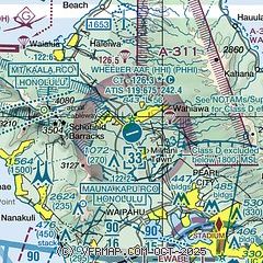
| Sectional chart |
|---|
|
| Airport distance calculator |
|---|
|
|
| Sunrise and sunset |
|---|
|
Times for 05-Jun-2026
| | Local
(UTC-10) | | Zulu
(UTC) |
|---|
| Morning civil twilight | | 05:25 | | 15:25 |
| Sunrise | | 05:50 | | 15:50 |
| Sunset | | 19:11 | | 05:11 |
| Evening civil twilight | | 19:36 | | 05:36 |
|
| Current date and time |
|---|
| Zulu (UTC) | 05-Jun-2026 21:58:30 |
|---|
| Local (UTC-10) | 05-Jun-2026 11:58:30 |
|---|
|
| METAR |
|---|
| PHHI | 052055Z AUTO 07010KT 10SM OVC042 25/17 A3019 RMK AO2 SLP214 60000 T02500167 50001 $
|
PHJR
10nm S | 052153Z 05010G19KT 10SM -RA FEW044 SCT060 28/17 A3015 RMK AO2 SLP215 P0000 T02830167 $
|
PHNL
10nm SE | 052153Z 06013G26KT 10SM FEW025 FEW050 29/18 A3014 RMK AO2 PK WND 05026/2136 SLP207 T02890178 $
|
PHNG
15nm E | 052057Z 07013G21KT 7SM SCT029 BKN050 27/19 A3015 RMK AO2 SLP204 T02670194 51002 $
|
|
| TAF |
|---|
| PHHI | 051600Z 0516/0622 10007KT 9999 SCT025 BKN035 QNH3016INS TEMPO 0516/0520 8000 -SHRA BR BKN015 BECMG 0519/0520 09008KT 9999 SCT025 BKN035 QNH3020INS TEMPO 0520/0602 11012G20KT 8000 -SHRA BKN020 BECMG 0605/0606 VRB06KT 9999 SCT025 BKN035 QNH3018INS TEMPO 0610/0615 8000 -SHRA BKN020 TX27/0523Z TN19/0615Z
|
PHJR
10nm S | 051728Z 0518/0618 06006KT P6SM FEW030 SCT050 FM052000 06010G18KT P6SM FEW025 SCT040 FM060600 06006KT P6SM FEW030 SCT050
|
PHNL
10nm SE | 051728Z 0518/0624 06011KT P6SM FEW025 BKN040 FM052000 06015G25KT P6SM FEW025 SCT040 FM060800 06011KT P6SM FEW025 SCT040 FM062000 06015G25KT P6SM FEW025 SCT040
|
PHNG
15nm E | 051700Z 0517/0615 07013G21KT 9999 BKN025 BKN050 QNH3007INS TEMPO 0518/0600 8000 -SHRA BR TX27/0523Z TN23/0613Z COR 1720 RTD 1720
|
|
| NOTAMs |
|---|
NOTAMs are issued by the DoD/FAA and will open in a separate window not controlled by AirNav.
|
|

