FAA INFORMATION EFFECTIVE 14 MAY 2026
Location
| FAA Identifier: | PLN |
| Lat/Long: | 45-34-15.3000N 084-47-48.2000W
45-34.255000N 084-47.803333W
45.5709167,-84.7967222
(estimated) |
| Elevation: | 720.6 ft. / 219.6 m (surveyed) |
| Variation: | 06W (1985) |
| From city: | 1 mile NW of PELLSTON, MI |
| Time zone: | UTC -4 (UTC -5 during Standard Time) |
| Zip code: | 49769 |
Airport Operations
| Airport use: | Open to the public |
| Activation date: | 03/1941 |
| Control tower: | no |
| ARTCC: | MINNEAPOLIS CENTER |
| FSS: | LANSING FLIGHT SERVICE STATION |
| NOTAMs facility: | PLN (NOTAM-D service available) |
| Attendance: | 0600-2300 |
| Wind indicator: | lighted |
| Segmented circle: | yes |
| Lights: | ACTVT MALSR RWY 32; REIL RWY 14, 05, & 23; PAPI RWY 14; HIRL RWY 14/32; MIRL RWY 05/23 - CTAF. VASI RWY 05 & 23 OPR CONSLY. |
| Beacon: | white-green (lighted land airport)
Operates sunset to sunrise. |
| Landing fee: | yes, FAC FEE WAIVED WITH MNM FUEL PURCHASE. |
| Fire and rescue: | ARFF index A |
| Airline operations: | ARPT CLSD TO UNSKED ACR ACFT WITH MORE THAN 30 PSGR SEATS EXCP 24 HR PPR. |
Airport Communications
| CTAF/UNICOM: | 123.0 |
| WX ASOS: | 119.025 (231-539-7700) |
| WX AWOS-3P at MGN (10 nm SW): | 119.925 (231-347-5231) |
| WX AWOS-3P at SLH (13 nm NE): | 118.175 (231-627-4671) |
| WX AWOS-3P at MCD (19 nm N): | 118.275 (906-847-3778) |
- APCH/DEP SVC PRVDD BY MINNEAPOLIS ARTCC ON FREQS 134.6/354.05 (PELLSTON RCAG).
- COMMUNICATIONS PRVDD BY LANSING RADIO ON FREQ 122.2 (PELLSTON RCO).
Nearby radio navigation aids
| VOR radial/distance | | VOR name | | Freq | | Var |
|---|
| PLNr243/6.6 | | PELLSTON VORTAC | | 111.80 | | 06W |
Airport Services
| Fuel available: | 100LL JET-A+ |
| Parking: | tiedowns |
| Airframe service: | MAJOR |
| Powerplant service: | MAJOR |
| Bottled oxygen: | NONE |
| Bulk oxygen: | NONE |
Runway Information
Runway 14/32
| Dimensions: | 6513 x 150 ft. / 1985 x 46 m |
| Surface: | asphalt/grooved, in good condition |
| Weight bearing capacity: | | Single wheel: | 78.0 | | Double wheel: | 125.0 | | Double tandem: | 211.0 |
|
| Runway edge lights: | high intensity |
| RUNWAY 14 | | RUNWAY 32 |
| Latitude: | 45-34.546300N | | 45-33.792725N |
| Longitude: | 084-48.413878W | | 084-47.329055W |
| Elevation: | 718.0 ft. | | 707.5 ft. |
| Traffic pattern: | left | | left |
| Runway heading: | 141 magnetic, 135 true | | 321 magnetic, 315 true |
| Declared distances: | TORA:6513 TODA:6513 ASDA:6512 LDA:6512 | | TORA:6513 TODA:6513 ASDA:6513 LDA:6513 |
| Markings: | precision, in fair condition | | precision, in fair condition |
| Visual slope indicator: | 4-light PAPI on left (3.00 degrees glide path)
UNUSBL BYD 8 DEGS RIGHT OF CNTRLN. | | |
| Approach lights: | | | MALSR: 1,400 foot medium intensity approach lighting system with runway alignment indicator lights |
| Runway end identifier lights: | yes | | no |
| Touchdown point: | yes, no lights | | yes, no lights |
| Instrument approach: | | | ILS/DME |
| Obstructions: | 82 ft. trees, 2850 ft. from runway, 32:1 slope to clear | | 56 ft. tree, 2739 ft. from runway, 865 ft. left of centerline, 45:1 slope to clear |
Runway 5/23
| Dimensions: | 5401 x 150 ft. / 1646 x 46 m |
| Surface: | asphalt/grooved, in good condition |
| Weight bearing capacity: | | Single wheel: | 78.0 | | Double wheel: | 125.0 | | Double tandem: | 211.0 |
|
| Runway edge lights: | medium intensity |
| RUNWAY 5 | | RUNWAY 23 |
| Latitude: | 45-34.043490N | | 45-34.675145N |
| Longitude: | 084-48.166185W | | 084-47.276230W |
| Elevation: | 710.6 ft. | | 720.5 ft. |
| Traffic pattern: | left | | left |
| Runway heading: | 051 magnetic, 045 true | | 231 magnetic, 225 true |
| Declared distances: | TORA:5395 TODA:5395 ASDA:5395 LDA:5395 | | TORA:5395 TODA:5395 ASDA:5395 LDA:5395 |
| Markings: | nonprecision, in good condition | | nonprecision, in good condition |
| Visual slope indicator: | 4-box VASI on right (3.00 degrees glide path) | | 4-box VASI on left (3.00 degrees glide path) |
| Runway end identifier lights: | yes | | yes |
| Touchdown point: | yes, no lights | | yes, no lights |
| Obstructions: | 50 ft. trees, 1500 ft. from runway, 300 ft. right of centerline, 26:1 slope to clear | | 18 ft. road, 669 ft. from runway, 316 ft. right of centerline, 26:1 slope to clear |
Airport Ownership and Management from official FAA records
| Ownership: | Publicly-owned |
| Owner: | EMMET COUNTY
1395 N US HIGHWAY 31
PELLSTON, MI 49769-9307
Phone 231-539-8441 |
| Manager: | JEFF MALLORY
1395 N US HIGHWAY 31
PELLSTON, MI 49769-9307
Phone 231-539-8442 |
Additional Remarks
| A39-05/23 | PCR VALUE: 290/F/B/X/T |
| A39-14/32 | PCR VALUE: 290/F/B/X/T |
| - | DEER & GULLS OCNLY ON & INVOF ARPT. |
| - | BE ALERT FOR SNOW REMOVAL EQUIP & ACTIVITY ON & INVOF RYS DURG WINTER MONTHS. |
| - | TWY B1 & E1 CLSD 1 NOV THRU 15 APR.. |
| - | SFC CONDS UNMON 2300-0530 DLY. |
| - | FOR CD IF UNA TO CTC ON FSS FREQ, CTC MINNEAPOLIS ARTCC AT 651-463-5588. |
Instrument Procedures
NOTE: All procedures below are presented as PDF files. If you need a reader for these files, you should download the free Adobe Reader.NOT FOR NAVIGATION. Please procure official charts for flight.
FAA instrument procedures published for use from 14 May 2026 at 0901Z to 11 June 2026 at 0900Z.
IAPs - Instrument Approach Procedures |
|---|
| ILS OR LOC RWY 32 | |
download (246KB) |
| RNAV (GPS) RWY 05 | |
download (217KB) |
| RNAV (GPS) RWY 23 | |
download (252KB) |
| RNAV (GPS) RWY 32 | |
download (274KB) |
| NOTE: Special Alternate Minimums apply **CHANGED** | |
download (140KB) |
| NOTE: Special Take-Off Minimums/Departure Procedures apply | |
download (355KB) |
Other nearby airports with instrument procedures:
KMGN - Harbor Springs Airport (10 nm SW)
KSLH - Cheboygan County Airport (13 nm NE)
6Y1 - Bois Blanc Island Airport (17 nm NE)
KMCD - Mackinac Island Airport (19 nm N)
83D - Mackinac County Airport (19 nm N)
|
|

Road maps at:
MapQuest
Bing
Google
| Aerial photo |
|---|
WARNING: Photo may not be current or correct
 Photo taken 29-Sep-2007
Do you have a better or more recent aerial photo of Pellston Regional/Emmet County Airport that you would like to share? If so, please send us your photo.
|
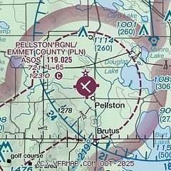
| Sectional chart |
|---|
|
| Airport distance calculator |
|---|
|
|
| Sunrise and sunset |
|---|
|
Times for 16-May-2026
| | Local
(UTC-4) | | Zulu
(UTC) |
|---|
| Morning civil twilight | | 05:33 | | 09:33 |
| Sunrise | | 06:08 | | 10:08 |
| Sunset | | 21:03 | | 01:03 |
| Evening civil twilight | | 21:38 | | 01:38 |
|
| Current date and time |
|---|
| Zulu (UTC) | 17-May-2026 01:53:50 |
|---|
| Local (UTC-4) | 16-May-2026 21:53:50 |
|---|
|
| METAR |
|---|
| KPLN | 170054Z AUTO 02012KT 10SM CLR 16/09 A2979 RMK AO2 SLP087 T01610094
|
KMGN
10nm SW | 170135Z AUTO 00000KT 10SM CLR 12/08 A2979 RMK AO2 T01230085
|
KSLH
13nm E | 170136Z AUTO 36005KT 10SM CLR 14/08 A2979 RMK AO2
|
KMCD
18nm N | 170136Z AUTO 03011KT 10SM CLR 15/04 A2980 RMK AO2
|
|
| TAF |
|---|
| KPLN | 161722Z 1618/1718 28015G25KT P6SM SKC FM162200 32010G17KT P6SM SKC FM170100 33004KT P6SM FEW250
|
|
| NOTAMs |
|---|
NOTAMs are issued by the DoD/FAA and will open in a separate window not controlled by AirNav.
|
|

