FAA INFORMATION EFFECTIVE 30 OCTOBER 2025
Location
| FAA Identifier: | PSB |
| Lat/Long: | 40-53-03.8090N 078-05-14.4300W
40-53.063483N 078-05.240500W
40.8843914,-78.0873417
(estimated) |
| Elevation: | 1948 ft. / 593.8 m (surveyed) |
| Variation: | 11W (2010) |
| From city: | 8 miles E of PHILIPSBURG, PA |
| Time zone: | UTC -5 (UTC -4 during Daylight Saving Time) |
| Zip code: | 16866 |
Airport Operations
| Airport use: | Open to the public |
| Activation date: | 11/1938 |
| Control tower: | no |
| ARTCC: | NEW YORK CENTER |
| FSS: | ALTOONA FLIGHT SERVICE STATION |
| NOTAMs facility: | AOO (NOTAM-D service available) |
| Attendance: | UNATNDD |
| Wind indicator: | yes |
| Segmented circle: | yes |
| Lights: | ACTVT MIRL RWY 06/24 & 16/34 - CTAF. |
Airport Communications
| CTAF: | 122.9 |
| WX AWOS-3: | 127.525 (814-343-4531) |
| WX AWOS-3 at UNV (11 nm E): | 127.65 (814-865-8799) |
| WX ASOS at FIG (18 nm NW): | 119.275 (814-765-9703) |
- APCH/DEP SVC PRVDD BY NEW YORK ARTCC ON FREQS 134.8/338.3 (PHILIPSBURG RCAG).
Nearby radio navigation aids
| VOR radial/distance | | VOR name | | Freq | | Var |
|---|
| PSBr256/4.7 | | PHILIPSBURG VORTAC | | 115.50 | | 10W |
| ETGr183/20.0 | | KEATING VORTAC | | 116.00 | | 10W |
| SLTr196/38.1 | | SLATE RUN VORTAC | | 113.90 | | 08W |
Airport Services
| Parking: | tiedowns |
| Airframe service: | NONE |
| Powerplant service: | NONE |
| Bottled oxygen: | NONE |
| Bulk oxygen: | NONE |
Runway Information
Runway 16/34
| Dimensions: | 5711 x 100 ft. / 1741 x 30 m |
| Surface: | asphalt, in poor condition
ASPH CRUMBLING AT INTXN OF RWYS CAUSING POTHOLES AND FOD. |
| Weight bearing capacity: | | Single wheel: | 48.0 | | Double wheel: | 60.0 | | Double tandem: | 90.0 |
|
| Runway edge lights: | medium intensity |
| Runway edge markings: | MRKGS EXTRMLY FADED. |
| RUNWAY 16 | | RUNWAY 34 |
| Latitude: | 40-53.603400N | | 40-52.743800N |
| Longitude: | 078-05.489417W | | 078-04.986733W |
| Elevation: | 1947.8 ft. | | 1921.5 ft. |
| Traffic pattern: | left | | left |
| Runway heading: | 167 magnetic, 156 true | | 347 magnetic, 336 true |
| Markings: | precision, in poor condition | | precision, in poor condition |
| Touchdown point: | yes, no lights | | yes, no lights |
| Obstructions: | 32 ft. trees, 415 ft. from runway, 279 ft. right of centerline, 6:1 slope to clear | | 57 ft. trees, 551 ft. from runway, 279 ft. left of centerline, 6:1 slope to clear |
Runway 6/24
| Dimensions: | 5006 x 100 ft. / 1526 x 30 m |
| Surface: | asphalt, in poor condition
ASPH CRUMBLING AT INTXN OF RWYS CAUSING POTHOLES AND FOD. |
| Weight bearing capacity: | | Single wheel: | 48.0 | | Double wheel: | 60.0 | | Double tandem: | 90.0 |
|
| Runway edge lights: | medium intensity |
| Runway edge markings: | MARKINGS EXTREMELY FADED. |
| RUNWAY 6 | | RUNWAY 24 |
| Latitude: | 40-52.670667N | | 40-53.203850N |
| Longitude: | 078-05.657733W | | 078-04.829500W |
| Elevation: | 1866.9 ft. | | 1916.8 ft. |
| Traffic pattern: | left | | left |
| Runway heading: | 061 magnetic, 050 true | | 241 magnetic, 230 true |
| Markings: | nonprecision, in poor condition | | nonprecision, in poor condition |
| Touchdown point: | yes, no lights | | yes, no lights |
| Obstructions: | 22 ft. trees, 337 ft. from runway, 162 ft. left of centerline, 6:1 slope to clear
RWY 24 CLOSED FOR NGT VISUAL APCH DUE TO OBSTNS. | | 42 ft. trees, 272 ft. from runway, 253 ft. left of centerline, 1:1 slope to clear |
Airport Ownership and Management from official FAA records
| Ownership: | Publicly-owned |
| Owner: | MID STATE REG ARPT AUTH
451 AIRPORT ROAD
PHILIPSBURG, PA 16866
Phone 814-342-6296 |
| Manager: | 451 AIRPORT ROAD
PHILIPSBURG, PA 16866 |
Additional Remarks
| - | DEER ON & INVOF ARPT. |
| - | HEAVY GLIDER ACTIVITY DURING DALGT HRS, ALL ALTS, ON AND INVOF AIRPORT AND WITHIN 15 NM EAST AND SOUTH OF ARPT. |
| - | CTC NG OPS 30.5/122.85/242.4 |
| - | FOR CD IF UNA TO CTC ON FSS FREQ, CTC NEW YORK ARTCC AT 631-468-1425. |
| - | ARPT ACES LTD; CTC MGR TO COORD 814-342-1080. |
Instrument Procedures
NOTE: All procedures below are presented as PDF files. If you need a reader for these files, you should download the free Adobe Reader.NOT FOR NAVIGATION. Please procure official charts for flight.
FAA instrument procedures published for use from 30 October 2025 at 0901Z to 27 November 2025 at 0900Z.
IAPs - Instrument Approach Procedures |
|---|
| RNAV (GPS) RWY 16 | |
download (227KB) |
| VOR RWY 24 | |
download (187KB) |
| NOTE: Special Take-Off Minimums/Departure Procedures apply | |
download (432KB) |
Other nearby airports with instrument procedures:
KUNV - State College Regional Airport (11 nm E)
N96 - Bellefonte Airport (12 nm E)
KFIG - Clearfield-Lawrence Airport (18 nm NW)
KRVL - Mifflin County Airport (24 nm SE)
KLHV - William T Piper Memorial Airport (34 nm NE)
|
|

Road maps at:
MapQuest
Bing
Google
| Aerial photo |
|---|
WARNING: Photo may not be current or correct
 Photo courtesy of AirNav, LLC
Photo taken 28-Oct-2011
looking south.
Photo courtesy of AirNav, LLC
Photo taken 28-Oct-2011
looking south.
Do you have a better or more recent aerial photo of Mid-State Airport that you would like to share? If so, please send us your photo.
|
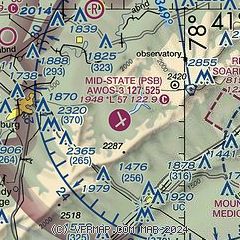
| Sectional chart |
|---|
|
| Airport distance calculator |
|---|
|
|
| Sunrise and sunset |
|---|
|
Times for 17-Nov-2025
| | Local
(UTC-5) | | Zulu
(UTC) |
|---|
| Morning civil twilight | | 06:33 | | 11:33 |
| Sunrise | | 07:03 | | 12:03 |
| Sunset | | 16:52 | | 21:52 |
| Evening civil twilight | | 17:21 | | 22:21 |
|
| Current date and time |
|---|
| Zulu (UTC) | 17-Nov-2025 12:35:55 |
|---|
| Local (UTC-5) | 17-Nov-2025 07:35:55 |
|---|
|
| METAR |
|---|
KUNV
12nm E | 171153Z 28008KT 8SM -SN BKN022 BKN029 OVC044 01/M04 A2981
|
KFIG
18nm NW | 171205Z AUTO 28009KT 1 3/4SM -SN BR BKN020 BKN028 OVC043 M01/M03 A2982 RMK AO2 SNB1156 P0000 T10061028
|
|
| TAF |
|---|
KUNV
12nm E | 171139Z 1712/1812 31011G17KT 6SM -SHSN BKN030 OVC060 FM171300 29015G20KT P6SM VCSH SCT025 BKN035 FM171500 29013G23KT P6SM BKN035 FM172200 29011G20KT P6SM SCT050 FM180000 28009G19KT P6SM BKN050 FM180400 27008KT P6SM BKN250 FM180600 26004KT P6SM BKN250
|
|
| NOTAMs |
|---|
NOTAMs are issued by the DoD/FAA and will open in a separate window not controlled by AirNav.
|
|

