FAA INFORMATION EFFECTIVE 25 DECEMBER 2025
Location
| FAA Identifier: | RNM |
| Lat/Long: | 33-02-21.0000N 116-54-54.9000W
33-02.350000N 116-54.915000W
33.0391667,-116.9152500
(estimated) |
| Elevation: | 1394.6 ft. / 425.1 m (surveyed) |
| Variation: | 12E (2010) |
| From city: | 2 miles W of RAMONA, CA |
| Time zone: | UTC -8 (UTC -7 during Daylight Saving Time) |
| Zip code: | 92065 |
Airport Operations
| Airport use: | Open to the public |
| Activation date: | 06/1947 |
| Control tower: | yes |
| ARTCC: | LOS ANGELES CENTER |
| FSS: | SAN DIEGO FLIGHT SERVICE STATION |
| NOTAMs facility: | RNM (NOTAM-D service available) |
| Attendance: | 0800-2000 |
| Pattern altitude: | 1000 FT SNGL ENG, 1500 FT MULT ENG. |
| Wind indicator: | lighted |
| Segmented circle: | yes |
| Lights: | ACTVT REIL RWY 27; MIRL RWY 09/27; TWY LGTS - CTAF. PAPI RWY 09 & 27 OPER 24 HRS. |
| Beacon: | white-green (lighted land airport)
Operates sunset to sunrise. |
Airport Communications
| CTAF: | 119.875 |
| UNICOM: | 122.95 |
| ATIS: | 132.025 |
| WX ASOS: | PHONE 760-239-7043 |
| RAMONA GROUND: | 121.65 [0800-2000] |
| RAMONA TOWER: | 119.875 [0800-2000] |
| SOCAL APPROACH: | 132.2 |
| SOCAL DEPARTURE: | 127.3 |
| CLASS B: | 127.3 ;333-028 SAN BLW 7,000 FT 132.2 ;029-061 SAN 14,000 FT & BLW 132.2 ;333-028 SAN 7,000 FT-11,000 F |
| CWARD DP: | 119.6 |
| PADRZ DP: | 119.6 |
| WX AWOS-3P at SEE (13 nm S): | 125.45 (619-449-1228) |
| WX ASOS at MYF (18 nm SW): | 126.9 (858-576-4337) |
| WX ASOS at CRQ (19 nm W): | PHONE 760-930-0864 |
Nearby radio navigation aids
| VOR radial/distance | | VOR name | | Freq | | Var |
|---|
| JLIr235/17.6 | | JULIAN VORTAC | | 113.75 | | 15E |
| MZBr030/21.9 | | MISSION BAY VORTAC | | 117.80 | | 15E |
| PGYr353/25.9 | | POGGI VORTAC | | 116.45 | | 14E |
| OCNr101/28.0 | | OCEANSIDE VORTAC | | 115.30 | | 15E |
| TIJr352/30.0 | | TIJUANA VOR/DME | | 116.50 | | 12E |
Airport Services
| Fuel available: | 100LL JET-A |
| Parking: | tiedowns |
| Airframe service: | MAJOR |
| Powerplant service: | MAJOR |
| Bottled oxygen: | NONE |
| Bulk oxygen: | NONE |
Runway Information
Runway 9/27
| Dimensions: | 5001 x 150 ft. / 1524 x 46 m |
| Surface: | asphalt, in good condition |
| Weight bearing capacity: | | Single wheel: | 75.0 | | Double wheel: | 95.0 | | Double tandem: | 170.0 |
|
| Runway edge lights: | medium intensity |
| RUNWAY 9 | | RUNWAY 27 |
| Latitude: | 33-02.420708N | | 33-02.278067N |
| Longitude: | 116-55.397425W | | 116-54.433235W |
| Elevation: | 1385.8 ft. | | 1394.5 ft. |
| Traffic pattern: | left | | left |
| Runway heading: | 087 magnetic, 099 true | | 267 magnetic, 279 true |
| Markings: | nonprecision, in good condition | | nonprecision, in good condition |
| Visual slope indicator: | 2-light PAPI on left (3.50 degrees glide path)
UNUSBL BYD 3.0 NM DUE TO TRRN. | | 2-light PAPI on left (3.50 degrees glide path) |
| Runway end identifier lights: | no | | yes |
| Touchdown point: | yes, no lights | | yes, no lights |
Helipad H1
| Dimensions: | 340 x 66 ft. / 104 x 20 m |
| Surface: | asphalt/concrete |
| Latitude: | 33-02.283000N | | |
| Longitude: | 116-54.849167W | | |
| Elevation: | 1391.0 ft. | | |
| Traffic pattern: | left | | left |
| Markings: | , in good condition | | |
Airport Ownership and Management from official FAA records
| Ownership: | Publicly-owned |
| Owner: | COUNTY OF SAN DIEGO
1960 JOE CROSSON DRIVE
EL CAJON, CA 92020-1235
Phone 619-956-4800 |
| Manager: | MEADOW CHASE
2926 MONTECITO ROAD
RAMONA, CA 92065
Phone 760-788-3366
ARPT MGR: CAN ALSO BE REACHED AT FALLBROOK COMMUNITY AIRPARK 760-723-8395. |
Additional Remarks
| - | HELIPAD PRKG N OF RWY NOT OPEN TO PUB. |
| - | WHEN TWR CLSD ACFT MUST SELF-ANNOUNCE ON CTAF PRIOR TO LDG OR TKOF. |
| - | PPR FOR ALL MIL ACFT CTC AMGR. |
| - | COPTER SKID LNDGS ON RWY AND TWY PROHIBITED. |
| - | HEL OPS TO HELIPAD S OF RWY RSTRD TO 6000 LBS OR LESS. |
| - | REPETITIVE COPTER TRG CONDUCTED ON HELIPAD S OF RWY AND TWY A W OF TWR. |
| - | HELIPAD S OF RWY UNLGTD. |
| - | HELIPAD S OF RWY DAYTIME VFR USE ONLY. |
| - | FOR CD WHEN ATCT CLSD CTC SOCAL APCH AT 800-448-3724. |
| - | NO COPTER HOVER TAXI ON TWY A FROM TWY A1 UP TO, BUT NOT INCLG, TWY A4. |
| - | VOLUNTARY JET CURFEW 2200-0700. NOISE SENSITIVE AREA NE-SE. NOISE ABATEMENT: TKOF CLIMB ON RWY HDG UNTIL 1900 FT MSL. |
| - | PPR FOR ALL ACFT MORE THAN 65000 LBS AT WEST TSNT RAMP ADJ TO ATCT; CTC AMGR. |
| - | FIRE FIGHTING ACFT ON AND IN THE VICINITY OF ARPT. |
| - | AIR TANKERS IN VCNTY YEAR-ROUND FRQLY FLY NONSTD PAT ENTRIES. |
| - | RWY 27 CALM WIND RWY. |
| - | FOR FIRE FIGHTING ACTIVITY CALL AMGR. |
| - | BE ALERT FOR BIRDS YEAR ROUND, VARIOUS SIZE AND SPECIES. OCNL COYOTE ON OR IN THE VICINITY OF RWY AND TWY. |
Instrument Procedures
NOTE: All procedures below are presented as PDF files. If you need a reader for these files, you should download the free Adobe Reader.NOT FOR NAVIGATION. Please procure official charts for flight.
FAA instrument procedures published for use from 25 December 2025 at 0901z to 22 January 2026 at 0900z.
IAPs - Instrument Approach Procedures |
|---|
| RNAV (GPS) RWY 09 | |
download (275KB) |
| RNAV (GPS)-B | |
download (369KB) |
| VOR/DME-A | |
download (392KB) |
| NOTE: Special Alternate Minimums apply | |
download (118KB) |
Departure Procedures |
|---|
| CWARD TWO (RNAV) | |
download (168KB) |
| PADRZ TWO (RNAV) | |
download (203KB) |
| NOTE: Special Take-Off Minimums/Departure Procedures apply | |
download (132KB) |
Other nearby airports with instrument procedures:
KSEE - Gillespie Field Airport (13 nm S)
KNKX - Miramar MCAS (Joe Foss Field) Airport (15 nm SW)
KMYF - Montgomery-Gibbs Executive Airport (18 nm SW)
KCRQ - Mc Clellan-Palomar Airport (19 nm W)
KSAN - San Diego International Airport (23 nm SW)
|
|

Road maps at:
MapQuest
Bing
Google
| Aerial photo |
|---|
WARNING: Photo may not be current or correct
 Photo courtesy of helihigh.com & Mark Robinson
Photo taken 21-Aug-2012
looking west.
Photo courtesy of helihigh.com & Mark Robinson
Photo taken 21-Aug-2012
looking west.
Do you have a better or more recent aerial photo of Ramona Airport that you would like to share? If so, please send us your photo.
|
| Sectional chart |
|---|
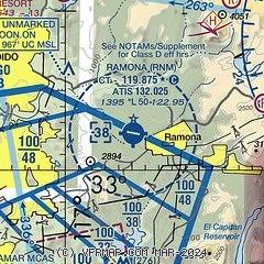
|
CAUTION: Diagram may not be current
 Download PDF
of official airport diagram from the FAA
| Airport distance calculator |
|---|
|
|
| Sunrise and sunset |
|---|
|
Times for 25-Dec-2025
| | Local
(UTC-8) | | Zulu
(UTC) |
|---|
| Morning civil twilight | | 06:22 | | 14:22 |
| Sunrise | | 06:50 | | 14:50 |
| Sunset | | 16:46 | | 00:46 |
| Evening civil twilight | | 17:13 | | 01:13 |
|
| Current date and time |
|---|
| Zulu (UTC) | 25-Dec-2025 14:09:51 |
|---|
| Local (UTC-8) | 25-Dec-2025 06:09:51 |
|---|
|
| METAR |
|---|
| KRNM | 251353Z AUTO 04003KT 3/4SM BR FEW005 SCT017 09/09 A3013 RMK AO2 VIS 1/4V2 SLP197 T00890089
|
KSEE
14nm S | 251355Z AUTO 00000KT 3SM BR BKN025 BKN032 13/13 A3012 RMK AO2
|
KNKX
15nm SW | 251355Z AUTO 05004KT 10SM BKN011 13/13 A3012 RMK AO2 SLP196 T01280128 $
|
KMYF
17nm SW | 251353Z 00000KT 6SM BR BKN013 BKN018 14/13 A3012 RMK AO2 SLP198 T01390133
|
KCRQ
19nm W | 251353Z AUTO 12003KT 10SM FEW050 14/13 A3011 RMK AO2 SLP195 T01440133
|
|
| TAF |
|---|
KNKX
15nm SW | 2503/2603 13008KT 9999 SCT015 BKN020 OVC029 QNH2997INS TEMPO 2503/2509 13010G25KT 8000 -SHRA BR BKN015 FM251500 16010G20KT 9999 SCT050 QNH2993INS TX18/2520Z TN15/2505Z
|
KCRQ
19nm W | 251126Z 2512/2612 15010KT P6SM OVC006 FM251400 16006KT P6SM VCSH BKN015 FM251600 19010KT P6SM SCT015 BKN035 FM252000 20010G18KT P6SM FEW040 BKN250 FM260200 16008KT P6SM BKN050 FM260600 15008KT P6SM OVC021
|
|
| NOTAMs |
|---|
NOTAMs are issued by the DoD/FAA and will open in a separate window not controlled by AirNav.
|
|


