FAA INFORMATION EFFECTIVE 25 DECEMBER 2025
Location
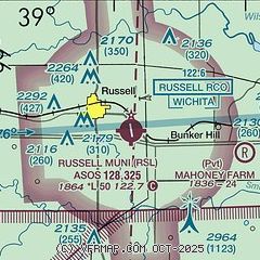
| FAA Identifier: | RSL |
| Lat/Long: | 38-52-16.9089N 098-48-41.7734W
38-52.281815N 098-48.696223W
38.8713636,-98.8116037
(estimated) |
| Elevation: | 1863.5 ft. / 568.0 m (surveyed) |
| Variation: | 07E (1995) |
| From city: | 2 miles SE of RUSSELL, KS |
| Time zone: | UTC -6 (UTC -5 during Daylight Saving Time) |
| Zip code: | 67665 |
Airport Operations
| Airport use: | Open to the public |
| Activation date: | 06/1945 |
| Control tower: | no |
| ARTCC: | KANSAS CITY CENTER |
| FSS: | WICHITA FLIGHT SERVICE STATION |
| NOTAMs facility: | RSL (NOTAM-D service available) |
| Attendance: | INTMNT |
| Wind indicator: | lighted |
| Segmented circle: | yes |
| Lights: | ACTVT REIL RWY 17 & 35; PAPI RWY 17 & 35; MIRL RWY 17/35 -- CTAF. |
| Beacon: | white-green (lighted land airport)
Operates sunset to sunrise. |
Airport Communications
| CTAF/UNICOM: | 122.7 |
| WX ASOS: | 128.325 (785-483-5770) |
- APCH/DEP CTL SVC PRVDD BY KANSAS CITY ARTCC (ZKC) ON FREQS 124.4/322.4 (RUSSELL RCAG).
Nearby radio navigation aids
| VOR radial/distance | | VOR name | | Freq | | Var |
|---|
| HYSr076/21.8 | | HAYS VORTAC | | 110.40 | | 10E |
Airport Services
| Fuel available: | 100LL
100LL:FUEL 24 HR SELF-SERVE. |
| Parking: | tiedowns |
| Airframe service: | MAJOR |
| Powerplant service: | MAJOR |
Runway Information
Runway 17/35
| Dimensions: | 5000 x 75 ft. / 1524 x 23 m |
| Surface: | concrete, in excellent condition |
| Weight bearing capacity: | | PCN 11 /R/C/X/U | | Single wheel: | 30.0 | | Double wheel: | 30.0 |
|
| Runway edge lights: | medium intensity |
| RUNWAY 17 | | RUNWAY 35 |
| Latitude: | 38-52.654833N | | 38-51.836000N |
| Longitude: | 098-48.705333W | | 098-48.590500W |
| Elevation: | 1859.7 ft. | | 1862.5 ft. |
| Traffic pattern: | left | | left |
| Runway heading: | 167 magnetic, 174 true | | 347 magnetic, 354 true |
| Markings: | nonprecision, in good condition | | nonprecision, in good condition |
| Visual slope indicator: | 4-light PAPI on left (3.00 degrees glide path) | | 4-light PAPI on left (3.00 degrees glide path) |
| Runway end identifier lights: | yes | | yes |
| Touchdown point: | yes, no lights | | yes, no lights |
| Obstructions: | 23 ft. rr, 1080 ft. from runway, 332 ft. left of centerline, 38:1 slope to clear | | none |
Runway 3/21
| Dimensions: | 1602 x 300 ft. / 488 x 91 m |
| Surface: | turf, in fair condition |
| Runway edge markings: | 03/21 MKD WITH HALF BARRELS ON POSTS PAINTED BLACK & YELLOW. |
| RUNWAY 3 | | RUNWAY 21 |
| Latitude: | 38-52.294667N | | 38-52.496167N |
| Longitude: | 098-48.955983W | | 098-48.738000W |
| Elevation: | 1856.0 ft. | | 1859.0 ft. |
| Traffic pattern: | left | | left |
| Runway heading: | 033 magnetic, 040 true | | 213 magnetic, 220 true |
| Runway end identifier lights: | no | | no |
| Obstructions: | 43 ft. trees, 505 ft. from runway, 89 ft. left of centerline, 12:1 slope to clear | | 42 ft. ant, 1034 ft. from runway, 146 ft. left of centerline, 24:1 slope to clear |
Airport Ownership and Management from official FAA records
| Ownership: | Publicly-owned |
| Owner: | CITY OF RUSSELL
CITY HALL
RUSSELL, KS 67665
Phone 785-483-6311 |
| Manager: | CHADD STEVENSON
CITY HALL, 133 W 8TH ST
RUSSELL, KS 67665
Phone 785-483-6911 |
Additional Remarks
| - | PUB PHONE ACCESS AT ARPT. |
| - | FOR CD IF UNA TO CTC ON FSS FREQ, CTC KANSAS CITY ARTCC AT 913-254-8508. |
| - | NO LINE OF SIGHT BETWEEN RWY ENDS. |
Instrument Procedures
NOTE: All procedures below are presented as PDF files. If you need a reader for these files, you should download the free Adobe Reader.NOT FOR NAVIGATION. Please procure official charts for flight.
FAA instrument procedures published for use from 25 December 2025 at 0901z to 22 January 2026 at 0900z.
IAPs - Instrument Approach Procedures |
|---|
| RNAV (GPS) RWY 17 **CHANGED** | |
download (252KB) |
| RNAV (GPS) RWY 35 **CHANGED** | |
download (256KB) |
| VOR/DME-A **CHANGED** | |
download (184KB) |
| NOTE: Special Alternate Minimums apply | |
download (140KB) |
| NOTE: Special Take-Off Minimums/Departure Procedures apply | |
download (147KB) |
Other nearby airports with instrument procedures:
KHYS - Hays Regional Airport (22 nm W)
9K7 - Ellsworth Municipal Airport (28 nm E)
KGBD - Great Bend Municipal Airport (32 nm S)
KRCP - Rooks County Regional Airport (37 nm NW)
KLQR - Larned-Pawnee County Airport (42 nm S)
|
|

Road maps at:
MapQuest
Bing
Google
| Aerial photo |
|---|
WARNING: Photo may not be current or correct
 Photo by Von Rothenberger
Photo taken 14-Aug-2010
looking south.
Photo by Von Rothenberger
Photo taken 14-Aug-2010
looking south.
Do you have a better or more recent aerial photo of Russell Municipal Airport that you would like to share? If so, please send us your photo.
|
| Sectional chart |
|---|
|
| Airport distance calculator |
|---|
|
|
| Sunrise and sunset |
|---|
|
Times for 18-Jan-2026
| | Local
(UTC-6) | | Zulu
(UTC) |
|---|
| Morning civil twilight | | 07:23 | | 13:23 |
| Sunrise | | 07:52 | | 13:52 |
| Sunset | | 17:39 | | 23:39 |
| Evening civil twilight | | 18:08 | | 00:08 |
|
| Current date and time |
|---|
| Zulu (UTC) | 18-Jan-2026 23:03:09 |
|---|
| Local (UTC-6) | 18-Jan-2026 17:03:09 |
|---|
|
| METAR |
|---|
| KRSL | 182253Z AUTO 01016G28KT 10SM SCT090 10/M06 A3004 RMK AO2 PK WND 35028/2245 SLP185 T01001056 $
|
|
| TAF |
|---|
| KRSL | 181723Z 1818/1918 33018G26KT P6SM SCT080 FM190000 35012KT P6SM SCT100 FM191200 36008KT P6SM OVC100
|
|
| NOTAMs |
|---|
NOTAMs are issued by the DoD/FAA and will open in a separate window not controlled by AirNav.
|
|


