FAA INFORMATION EFFECTIVE 14 MAY 2026
Location
| FAA Identifier: | RZL |
| Lat/Long: | 40-56-52.1640N 087-10-57.5330W
40-56.869400N 087-10.958883W
40.9478233,-87.1826481
(estimated) |
| Elevation: | 698.3 ft. / 212.8 m (surveyed) |
| Variation: | 02W (1990) |
| From city: | 1 mile NW of RENSSELAER, IN |
| Time zone: | UTC -5 (UTC -6 during Standard Time) |
| Zip code: | 47978 |
Airport Operations
| Airport use: | Open to the public |
| Activation date: | 05/1941 |
| Control tower: | no |
| ARTCC: | CHICAGO CENTER |
| FSS: | TERRE HAUTE FLIGHT SERVICE STATION |
| NOTAMs facility: | HUF (NOTAM-D service available) |
| Attendance: | MON-FRI 0800-1700 |
| Wind indicator: | lighted |
| Segmented circle: | no |
| Lights: | ACTVT REIL RWY 18 & 36; MIRL RWY 18/36 - CTAF. PAPI RWY 18 & 36 ON CONSLY. |
| Beacon: | white-green (lighted land airport)
Operates sunset to sunrise. |
Airport Communications
| CTAF/UNICOM: | 122.8 |
| WX AWOS-3P: | 119.175 (219-866-7167) |
- APCH/DEP SVC PRVDD BY CHICAGO ARTCC (ZAU) ON FREQS 132.5/284.7 (KANKAKEE RCAG).
Nearby radio navigation aids
| VOR radial/distance | | VOR name | | Freq | | Var |
|---|
| BVTr347/24.1 | | BOILER VORTAC | | 115.10 | | 01E |
| EONr123/33.6 | | PEOTONE VORTAC | | 113.20 | | 02E |
| CGTr151/38.0 | | CHICAGO HEIGHTS VORTAC | | 114.20 | | 02E |
Airport Services
| Fuel available: | 100LL JET-A+
100LL:SELF SVC FUEL H24 WITH CREDIT CARD. |
| Parking: | hangars and tiedowns |
| Airframe service: | MAJOR |
| Powerplant service: | MAJOR |
Runway Information
Runway 18/36
| Dimensions: | 4000 x 60 ft. / 1219 x 18 m |
| Surface: | concrete, in good condition |
| Weight bearing capacity: | |
| Runway edge lights: | medium intensity |
| RUNWAY 18 | | RUNWAY 36 |
| Latitude: | 40-57.205010N | | 40-56.546262N |
| Longitude: | 087-10.890068W | | 087-10.886777W |
| Elevation: | 698.2 ft. | | 674.4 ft. |
| Traffic pattern: | left | | left |
| Runway heading: | 182 magnetic, 180 true | | 002 magnetic, 360 true |
| Markings: | nonprecision, in fair condition | | nonprecision, in fair condition |
| Visual slope indicator: | 2-light PAPI on left (3.00 degrees glide path) | | 2-light PAPI on left (3.00 degrees glide path) |
| Runway end identifier lights: | yes | | yes |
| Touchdown point: | yes, no lights | | yes, no lights |
| Obstructions: | 29 ft. road, 790 ft. from runway, 20:1 slope to clear | | 15 ft. road, 520 ft. from runway, 21:1 slope to clear
CROPS 120 FT R OF CNTRLN AT THR; ROAD 245 FT R OF CNTRLN. TIE-DOWN AREA 100 FT FM RWY END 130 FT L OF CNTRLN. |
Runway 9/27
| Dimensions: | 1450 x 150 ft. / 442 x 46 m |
| Surface: | turf, in good condition |
| Runway edge markings: | ORANGE CONES. |
| RUNWAY 9 | | RUNWAY 27 |
| Latitude: | 40-56.850913N | | 40-56.853620N |
| Longitude: | 087-11.310750W | | 087-10.995763W |
| Elevation: | 678.9 ft. | | 684.2 ft. |
| Traffic pattern: | left | | left |
| Runway heading: | 091 magnetic, 089 true | | 271 magnetic, 269 true |
| Markings: | none | | none |
| Runway end identifier lights: | no | | no |
| Touchdown point: | yes, no lights | | yes, no lights |
Airport Ownership and Management from official FAA records
| Ownership: | Publicly-owned |
| Owner: | JASPER COUNTY AIRPORT AUTHORITY
2326 W. CLARK ST.
RENSSELAER, IN 47978
Phone 219-866-2100 |
| Manager: | EMILY HACKLER
2326 W. CLARK ST.
RENSSELAER, IN 47978
Phone 219-866-2100
219-869-5103. |
Additional Remarks
| A57-27 | APCH SLOPE 35:1 TO DTHR. |
| - | COND UNMNT 1700-0800. |
| - | FOR CD CTC CHICAGO ARTCC AT 630-906-8921. |
Instrument Procedures
NOTE: All procedures below are presented as PDF files. If you need a reader for these files, you should download the free Adobe Reader.NOT FOR NAVIGATION. Please procure official charts for flight.
FAA instrument procedures published for use from 14 May 2026 at 0901Z to 11 June 2026 at 0900Z.
IAPs - Instrument Approach Procedures |
|---|
| RNAV (GPS) RWY 18 | |
download (249KB) |
| RNAV (GPS) RWY 36 | |
download (243KB) |
| NOTE: Special Alternate Minimums apply | |
download (146KB) |
| NOTE: Special Take-Off Minimums/Departure Procedures apply | |
download (482KB) |
Other nearby airports with instrument procedures:
50I - Kentland Municipal Airport (16 nm SW)
KMCX - White County Airport (24 nm SE)
KRWN - Arens Field Airport (27 nm E)
KIKK - Greater Kankakee Airport (31 nm W)
KVPZ - Porter County Regional Airport (31 nm N)
|
|

Road maps at:
MapQuest
Bing
Google
| Aerial photo |
|---|
WARNING: Photo may not be current or correct

Do you have a better or more recent aerial photo of Jasper County Airport that you would like to share? If so, please send us your photo.
|
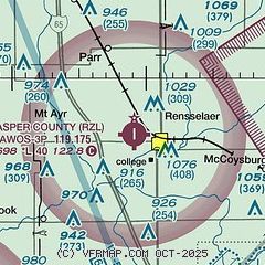
| Sectional chart |
|---|
|
| Airport distance calculator |
|---|
|
|
| Sunrise and sunset |
|---|
|
Times for 22-May-2026
| | Local
(UTC-5) | | Zulu
(UTC) |
|---|
| Morning civil twilight | | 04:54 | | 09:54 |
| Sunrise | | 05:26 | | 10:26 |
| Sunset | | 20:05 | | 01:05 |
| Evening civil twilight | | 20:37 | | 01:37 |
|
| Current date and time |
|---|
| Zulu (UTC) | 22-May-2026 13:19:16 |
|---|
| Local (UTC-5) | 22-May-2026 08:19:16 |
|---|
|
| METAR |
|---|
| KRZL | 221255Z AUTO 06014G17KT 10SM BKN046 13/06 A3013 RMK AO2
|
|
| TAF |
|---|
KLAF
34nm S | 221120Z 2212/2312 07011KT P6SM SCT025 BKN050 FM221400 07010KT P6SM SCT020 BKN035 FM222000 07012G19KT P6SM VCSH BKN015 FM230000 06010KT 6SM BR VCSH SCT008 BKN011 FM230500 03007KT 5SM BR VCSH OVC008
|
KGYY
41nm N | 221128Z 2212/2312 05015KT P6SM BKN040 OVC150 FM230200 07011KT P6SM SCT015 BKN025 FM230500 05011KT P6SM SCT008 BKN015 PROB30 2306/2312 6SM -SHRA BKN008
|
|
| NOTAMs |
|---|
NOTAMs are issued by the DoD/FAA and will open in a separate window not controlled by AirNav.
|
|

