FAA INFORMATION EFFECTIVE 14 MAY 2026
Location
| FAA Identifier: | S10 |
| Lat/Long: | 47-51-57.6370N 119-56-33.7260W
47-51.960617N 119-56.562100W
47.8660103,-119.9427017
(estimated) |
| Elevation: | 1263.1 ft. / 385.0 m (surveyed) |
| Variation: | 20E (1985) |
| From city: | 3 miles NE of CHELAN, WA |
| Time zone: | UTC -7 (UTC -8 during Standard Time) |
| Zip code: | 98816 |
Airport Operations
| Airport use: | Open to the public |
| Activation date: | 12/1938 |
| Control tower: | no |
| ARTCC: | SEATTLE CENTER |
| FSS: | SEATTLE FLIGHT SERVICE STATION |
| NOTAMs facility: | SEA (NOTAM-D service available) |
| Attendance: | MON-FRI 0700-1500 |
| Wind indicator: | lighted |
| Segmented circle: | yes |
| Lights: | ACTVT MIRL RY 02/20 - CTAF. |
| Beacon: | white-green (lighted land airport)
Operates sunset to sunrise. |
Airport Communications
| CTAF: | 122.9 |
| UNICOM: | 122.95 |
Nearby radio navigation aids
| VOR radial/distance | | VOR name | | Freq | | Var |
|---|
| EATr006/30.0 | | WENATCHEE VOR/DME | | 114.35 | | 15E |
| EPHr303/36.0 | | EPHRATA VORTAC | | 112.60 | | 21E |
Airport Services
| Fuel available: | 100LL JET-A
100LL:SELF-SERVICE FUEL AVAILABLE 24/7 |
| Parking: | tiedowns |
| Airframe service: | MINOR |
| Powerplant service: | MINOR |
| Bottled oxygen: | NONE |
| Bulk oxygen: | NONE |
Runway Information
Runway 2/20
| Dimensions: | 3506 x 60 ft. / 1069 x 18 m |
| Surface: | asphalt, in excellent condition |
| Weight bearing capacity: | |
| Runway edge lights: | medium intensity |
| RUNWAY 2 | | RUNWAY 20 |
| Latitude: | 47-51.753268N | | 47-52.167700N |
| Longitude: | 119-56.858910W | | 119-56.263233W |
| Elevation: | 1254.3 ft. | | 1263.1 ft. |
| Traffic pattern: | right | | left |
| Displaced threshold: | 448 ft. | | 199 ft. |
| Markings: | basic, in good condition | | basic, in good condition |
| Visual slope indicator: | | | 2-light PAPI on left |
| Touchdown point: | yes, no lights | | yes, no lights |
| Obstructions: | 15 ft. road, 203 ft. from runway
RWY 02, ROAD 0-200 FT FM THR ON BOTH SIDES, ROAD SIGN +7 FT, 170 FT FM THR, 77 FT L, 2 FT UTILITY BOX 110 FT FM THR, 78 FT L. | | none
RWY 20 ROAD IN PRIM SFC 125 FT FM THR; ROAD AT 124 FT FM THR AND 4 FT SIGNS 119 FT FM THR; 3 FT SIGN 18 FT FM THR, 67 FT R; 2 FT SIGN 18 FT FM THR, 72 FT R; 2 FT PIPE 81 FT FM THR, 15 FT L; 2 FT SIGN 23 FT FM THR, 79 L; 5 FT SIGN 188 FT FM THR, 65 FT R. |
Airport Ownership and Management from official FAA records
| Ownership: | Publicly-owned |
| Owner: | CITY OF CHELAN/PORT OF CHELAN
PO BOX 1669
CHELAN, WA 98816
Phone 509-682-4037 |
| Manager: | PAUL LERMA
32 AIRPORT ROAD
CHELAN, WA 98816
Phone 509-682-5976 |
Additional Remarks
| - | RY 20 IS PREFD APRCH RY. |
| - | MAY THROUGH OCTOBER PARACHUTE JUMPING ACTIVITIES ON AIRFIELD. |
| - | FOR CD CTC SEATTLE ARTCC AT 253-351-3694. |
Instrument Procedures
There are no published instrument procedures at S10.
Some nearby airports with instrument procedures:
KEAT - Pangborn Memorial Airport (30 nm S)
3W7 - Grand Coulee Dam Airport (35 nm E)
KEPH - Ephrata Municipal Airport (38 nm SE)
KOMK - Omak Airport (40 nm NE)
KMWH - Grant County International Airport (47 nm SE)
|
|

Road maps at:
MapQuest
Bing
Google
| Aerial photo |
|---|
WARNING: Photo may not be current or correct
 Photo taken 10-Sep-2011
looking north.
Photo taken 10-Sep-2011
looking north.
Do you have a better or more recent aerial photo of Lake Chelan Airport that you would like to share? If so, please send us your photo.
|
| Sectional chart |
|---|
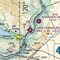
|
| Airport distance calculator |
|---|
|
|
| Sunrise and sunset |
|---|
|
Times for 19-May-2026
| | Local
(UTC-7) | | Zulu
(UTC) |
|---|
| Morning civil twilight | | 04:40 | | 11:40 |
| Sunrise | | 05:17 | | 12:17 |
| Sunset | | 20:35 | | 03:35 |
| Evening civil twilight | | 21:13 | | 04:13 |
|
| Current date and time |
|---|
| Zulu (UTC) | 19-May-2026 13:00:19 |
|---|
| Local (UTC-7) | 19-May-2026 06:00:19 |
|---|
|
| TAF |
|---|
KEAT
30nm S | 191140Z 1912/2012 30008KT P6SM FEW160 FM200000 30015KT P6SM SCT120 FM200200 31019G29KT P6SM SCT170 FM200500 29015G24KT P6SM SCT120 FM201000 32010KT P6SM SCT250
|
|
| NOTAMs |
|---|
NOTAMs are issued by the DoD/FAA and will open in a separate window not controlled by AirNav.
|
|

