FAA INFORMATION EFFECTIVE 14 MAY 2026
Location
| FAA Identifier: | SLN |
| Lat/Long: | 38-47-26.2000N 097-39-08.0000W
38-47.436667N 097-39.133333W
38.7906111,-97.6522222
(estimated) |
| Elevation: | 1288 ft. / 392.6 m (surveyed) |
| Variation: | 07E (1990) |
| From city: | 3 miles SW of SALINA, KS |
| Time zone: | UTC -5 (UTC -6 during Standard Time) |
| Zip code: | 67401 |
Airport Operations
| Airport use: | Open to the public |
| Control tower: | yes |
| ARTCC: | KANSAS CITY CENTER |
| FSS: | WICHITA FLIGHT SERVICE STATION |
| NOTAMs facility: | SLN (NOTAM-D service available) |
| Attendance: | CONTINUOUS |
| Wind indicator: | yes |
| Segmented circle: | no |
| Lights: | WHEN ATCT CLSD ACTVT MIRL RY 12/30; PAPI RYS 12 & 30; HIRL RY 17/35; MALS & PAPI RYS 17 & 35; MALSR RY 35 - CTAF. |
| Beacon: | white-green (lighted land airport)
Operates sunset to sunrise. |
| Fire and rescue: | ARFF index A |
| Airline operations: | PPR 24 HRS FOR UNSKED ACR OPNS WITH MORE THAN 30 PSGR SEATS CALL AMGR 785-827-3914. ARFF INDEX B PROVDD SUN-SAT 0600 TO 2200 (LOCAL). INDEX E AVBL UPON REQ. |
Airport Communications
| CTAF: | 119.3 |
| UNICOM: | 122.95 |
| ATIS: | 120.15 |
| WX ASOS: | 120.15 (785-823-3402) |
| SALINA GROUND: | 121.9 360.8 [0700-2300] |
| SALINA TOWER: | 119.3 257.7 124.35 [0700-2300] |
| ARNG OPS: | 142.2 229.2 40.525 |
| EMERG: | 243.0 |
- APCH/DEP CTL SVC PRVDD BY KANSAS CITY ARTCC (ZKC) ON FREQS 134.9/363.2 (SALINA RCAG).
Nearby radio navigation aids
| VOR radial/distance | | VOR name | | Freq | | Var |
|---|
| SLNr183/8.2 | | SALINA VORTAC | | 117.10 | | 07E |
| FRIr248/(38.5) | | FORT RILEY VOR | | 109.40 | | 06E |
| NDB name | | Hdg/Dist | | Freq | | Var | | ID |
|---|
| FLORY | | 350/6.6 | | 344 | | 07E | | SL | ... .-.. |
| HERINGTON | | 272/39.8 | | 407 | | 06E | | HRU | .... .-. ..- |
Airport Services
| Fuel available: | 100LL JET-A |
| Parking: | hangars and tiedowns |
| Airframe service: | MAJOR |
| Powerplant service: | MAJOR |
| Bottled oxygen: | NONE |
| Bulk oxygen: | HIGH |
Runway Information
Runway 17/35
| Dimensions: | 12301 x 150 ft. / 3749 x 46 m |
| Surface: | asphalt/concrete, in good condition |
| Weight bearing capacity: | | Single wheel: | 75.0 | | Double wheel: | 200.0 | | Double tandem: | 360.0 | | Dual double tandem: | 600.0 |
|
| Runway edge lights: | high intensity |
| RUNWAY 17 | | RUNWAY 35 |
| Latitude: | 38-48.624547N | | 38-46.598300N |
| Longitude: | 097-38.757567W | | 097-38.752475W |
| Elevation: | 1245.8 ft. | | 1271.1 ft. |
| Traffic pattern: | left | | left |
| Runway heading: | 173 magnetic, 180 true | | 353 magnetic, 360 true |
| Declared distances: | TORA:12300 TODA:12300 ASDA:12300 LDA:12300 | | TORA:12300 TODA:12300 ASDA:12300 LDA:12300 |
| Markings: | precision, in good condition | | precision, in good condition |
| Visual slope indicator: | 4-light PAPI on left (3.00 degrees glide path) | | 4-light PAPI on right (3.00 degrees glide path) |
| Approach lights: | MALS: 1,400 foot medium intensity approach lighting system | | MALSR: 1,400 foot medium intensity approach lighting system with runway alignment indicator lights |
| Touchdown point: | yes, no lights | | yes, no lights |
| Instrument approach: | | | ILS |
| Obstructions: | none | | 30 ft. gnd, 1375 ft. from runway, 500 ft. left of centerline, 39:1 slope to clear |
Runway 12/30
| Dimensions: | 6510 x 100 ft. / 1984 x 30 m |
| Surface: | asphalt, in excellent condition |
| Weight bearing capacity: | | Single wheel: | 55.0 | | Double wheel: | 68.0 | | Double tandem: | 125.0 |
|
| Runway edge lights: | medium intensity |
| RUNWAY 12 | | RUNWAY 30 |
| Latitude: | 38-47.614740N | | 38-46.891765N |
| Longitude: | 097-40.018592W | | 097-39.006542W |
| Elevation: | 1258.3 ft. | | 1271.7 ft. |
| Traffic pattern: | left | | left |
| Runway heading: | 125 magnetic, 132 true | | 305 magnetic, 312 true |
| Declared distances: | TORA:6510 TODA:6510 ASDA:6510 LDA:6510 | | TORA:6510 TODA:6510 ASDA:6510 LDA:6510 |
| Markings: | nonprecision, in good condition | | nonprecision, in good condition |
| Visual slope indicator: | 4-light PAPI on left (3.00 degrees glide path) | | 4-light PAPI on left (3.00 degrees glide path) |
| Touchdown point: | yes, no lights | | yes, no lights |
Runway 18/36
| Dimensions: | 4301 x 75 ft. / 1311 x 23 m |
| Surface: | asphalt, in excellent condition |
| Weight bearing capacity: | | PCN 11 /F/C/Y/U | | Single wheel: | 30.0 |
|
| Operational restrictions: | RWY 18/36 NOT AVBL FOR PART 121/PART 380 OPS WITH SKED PAX CARRYING OPS MORE THAN 9 PAX SEATS AND NON-SKED PAX CARRYING OPS MORE THAN 30 PAX SEATS. |
| RUNWAY 18 | | RUNWAY 36 |
| Latitude: | 38-47.628835N | | 38-46.920367N |
| Longitude: | 097-39.688120W | | 097-39.686258W |
| Elevation: | 1253.7 ft. | | 1287.8 ft. |
| Traffic pattern: | left | | left |
| Runway heading: | 173 magnetic, 180 true | | 353 magnetic, 360 true |
| Declared distances: | TORA:4300 TODA:4300 ASDA:4300 LDA:4300 | | TORA:4300 TODA:4300 ASDA:4300 LDA:4300 |
| Markings: | nonprecision, in good condition | | nonprecision, in good condition |
| Touchdown point: | yes, no lights | | yes, no lights |
Runway 4/22
| Dimensions: | 3648 x 75 ft. / 1112 x 23 m |
| Surface: | asphalt, in good condition |
| Weight bearing capacity: | | PCN 5 /F/C/Y/U | | Single wheel: | 100.0 | | Double wheel: | 135.0 | | Double tandem: | 230.0 |
|
| Operational restrictions: | RWY 04/22 NOT AVBL FOR PART 121/PART 380 OPS WITH SKED PAX CARRYING OPS MORE THAN 9 PAX SEATS AND NON-SKED PAX CARRYING OPS MORE THAN 30 PAX SEATS. |
| RUNWAY 4 | | RUNWAY 22 |
| Latitude: | 38-47.171478N | | 38-47.566615N |
| Longitude: | 097-39.368672W | | 097-38.790255W |
| Elevation: | 1270.7 ft. | | 1256.0 ft. |
| Traffic pattern: | left | | left |
| Runway heading: | 042 magnetic, 049 true | | 222 magnetic, 229 true |
| Declared distances: | TORA:3648 TODA:3648 ASDA:3648 LDA:3648 | | TORA:3648 TODA:3648 ASDA:3648 LDA:3648 |
| Markings: | basic, in fair condition | | basic, in fair condition |
| Touchdown point: | yes, no lights | | yes, no lights |
| Obstructions: | none | | 46 ft. bldg, lighted, 1550 ft. from runway, 200 ft. left of centerline, 29:1 slope to clear |
Helipad H1
| Dimensions: | 57 x 57 ft. / 17 x 17 m |
| Surface: | concrete, in good condition |
| Latitude: | 38-47.310667N | | |
| Longitude: | 097-38.584333W | | |
| Elevation: | 1260.0 ft. | | |
| Traffic pattern: | left | | left |
Helipad H4
| Dimensions: | 57 x 43 ft. / 17 x 13 m |
| Surface: | asphalt, in good condition |
| Latitude: | 38-47.621500N | | |
| Longitude: | 097-39.283667W | | |
| Elevation: | 1253.0 ft. | | |
| Traffic pattern: | left | | left |
Helipad H5
| Dimensions: | 57 x 57 ft. / 17 x 17 m |
| Surface: | concrete, in good condition |
| Latitude: | 38-47.782167N | | |
| Longitude: | 097-39.430167W | | |
| Elevation: | 1250.0 ft. | | |
| Traffic pattern: | left | | left |
Helipad H3
| Dimensions: | 30 x 30 ft. / 9 x 9 m |
| Surface: | concrete, in good condition |
| Latitude: | 38-47.780167N | | |
| Longitude: | 097-39.136500W | | |
| Elevation: | 1250.0 ft. | | |
| Traffic pattern: | left | | left |
Helipad H2
| Dimensions: | 29 x 28 ft. / 9 x 9 m |
| Surface: | asphalt, in good condition |
| Latitude: | 38-47.842333N | | |
| Longitude: | 097-38.638500W | | |
| Elevation: | 1260.0 ft. | | |
| Traffic pattern: | left | | left |
Helipad H6
| Dimensions: | 29 x 29 ft. / 9 x 9 m |
| Surface: | concrete, in good condition |
| Latitude: | 38-47.007333N | | |
| Longitude: | 097-39.433167W | | |
| Elevation: | 1253.0 ft. | | |
| Traffic pattern: | left | | left |
Airport Ownership and Management from official FAA records
| Ownership: | Publicly-owned |
| Owner: | SALINA ARPT AUTH
3237 ARNOLD AVENUE
SALINA, KS 67401
Phone 785-827-3914 |
| Manager: | MR. PIETER MILLER
3237 ARNOLD AVENUE
SALINA, KS 67401
Phone 785-827-3914 |
Additional Remarks
| A39-12/30 | PCR VALUE: 176/F/D/X/T |
| A39-17/35 | PCR VALUE: 840/F/D/X/T |
| - | SVC: FLUID- LPOX, HPOX, LPNIT, LOX (72HR NOTICE) DEICING SERVICE TYPE 1& TYPE 4 OIL 0-128-148 AVBL IN QUART CANS TRANS SVC AVBL AT FBO. LOGISTICAL SVC AVBL FOR DETS AND RON AT FBO (AVFLIGHT SALINA, 785-825-6739/CELL 785-819-2236.) |
| - | ARNG: RAMP SPACE AVBL TO ACCOMMODATE UP TO 80 FIGHTERS. SMOKY HILL ANG WEAPONS RANGE 16 NM TO THE SOUTHWEST. COORD RANGE TIME AT DSN 743-7600 EXT 148 OR 785-646-3318. MILITARY BILLETING AVAILABLE 888-577-8257. LOGISTIC EQPT AVBL FOR USE. ORDNANCE STORAGE FOR CLASS 1.3 THRU 1.4. |
| - | ARNG: TRAN ARMY ACFT CTC SALINA GUARD OPS ON 229.2 OR 40.525 SC RED. LIMITED UH-60 SVC AND MAINT AVBL. |
| - | 100LL SELF SVC FUELING STN LOCATED SOUTH OF KANSAS ANG. |
| - | GND SUPPORT AND LOGISTICS EQUIP AVBL INCL TUGS, BOBTAILS, TOW BARS AND AIRSTAIRS. |
| - | H1 INGRESS/EGRESS 070 DEG THROUGH 040 DEG TO AVOID CTL TWR. |
| - | ALL HELIPADS DALGT USE ONLY. |
| - | H3, H4, H5, H6 USED EXTSVLY FOR TRNG. |
| - | H2, H3 LTD TO 6,000 LBS; H4, H5 LTD TO 25,000 LBS. |
| - | NO LINE OF SIGHT, ALL RYS DUE TO GRADIENT, TOPOGRAPHY & TREES. |
| - | NOISE ABATEMENT: HEAVY & MIL ACFT TPA AT 2,800 MSL OR ABOVE. |
| - | FOR CD IF UNA TO CTC ON FSS FREQ, CTC KANSAS CITY ARTCC AT 913-254-8508. |
| - | BTN 0001-0459L ACR OPNS INVOLVING ACFT WITH MORE THAN 9 PSGRS SEATS ARE NOT AUTH IN EXCESS OF 15 MINS BFR OR AFT SKED ARR OR DEP TIMES WO PRIOR COORD WITH AMGR TO CFM THAT ARFF SVCS ARE AVBL PRIOR TO LNDG OR TKOF. CALL AMGR 785-827-3914. |
| - | SEASONAL MOWING OPNS ADJ TO RYS & TWYS. |
| - | CALM WND RY 35. |
| - | ARNG: OPR 1300-2300Z++ TUE-FRI; OCNL SAT EXC HOL. LTD MAINT UH-60. ARNG, AR AND A CTC ARNG OPS PRIOR TO LDG OR CALL 785-646-3430 FOR OPERATIONS. |
| - | SVC: JASU- 2(A/M32-95) 2(A/M32-60B) 1(A/M32-86D). |
Instrument Procedures
NOTE: All procedures below are presented as PDF files. If you need a reader for these files, you should download the free Adobe Reader.NOT FOR NAVIGATION. Please procure official charts for flight.
FAA instrument procedures published for use from 14 May 2026 at 0901Z to 11 June 2026 at 0900Z.
IAPs - Instrument Approach Procedures |
|---|
| ILS OR LOC RWY 35 **CHANGED** | |
download (262KB) |
| RNAV (GPS) RWY 12 | |
download (210KB) |
| RNAV (GPS) RWY 17 | |
download (225KB) |
| RNAV (GPS) RWY 30 | |
download (213KB) |
| RNAV (GPS) RWY 35 | |
download (233KB) |
| VOR RWY 17 | |
download (254KB) |
| NDB RWY 35 | |
download (211KB) |
| NOTE: Special Alternate Minimums apply **CHANGED** | |
download (147KB) |
| NOTE: Special Take-Off Minimums/Departure Procedures apply | |
download (147KB) |
Other nearby airports with instrument procedures:
K78 - Abilene Municipal Airport (21 nm E)
KMPR - Mc Pherson Airport (26 nm S)
9K7 - Ellsworth Municipal Airport (27 nm W)
47K - Moundridge Municipal Airport (36 nm S)
KLYO - Lyons-Rice County Municipal Airport (38 nm SW)
|
|

Road maps at:
MapQuest
Bing
Google
| Aerial photo |
|---|
WARNING: Photo may not be current or correct
 Photo courtesy of the Salina Airport Authority
Photo taken 23-Jun-2006
Photo courtesy of the Salina Airport Authority
Photo taken 23-Jun-2006
Do you have a better or more recent aerial photo of Salina Regional Airport that you would like to share? If so, please send us your photo.
|
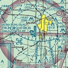
| Sectional chart |
|---|
|
| Airport distance calculator |
|---|
|
|
| Sunrise and sunset |
|---|
|
Times for 31-May-2026
| | Local
(UTC-5) | | Zulu
(UTC) |
|---|
| Morning civil twilight | | 05:38 | | 10:38 |
| Sunrise | | 06:09 | | 11:09 |
| Sunset | | 20:48 | | 01:48 |
| Evening civil twilight | | 21:19 | | 02:19 |
|
| Current date and time |
|---|
| Zulu (UTC) | 01-Jun-2026 00:19:56 |
|---|
| Local (UTC-5) | 31-May-2026 19:19:56 |
|---|
|
| METAR |
|---|
| KSLN | 312353Z 04006KT 10SM FEW046 29/21 A2985 RMK AO2 SLP095 T02890211 10294 20239 55002 $
|
|
| TAF |
|---|
| KSLN | 311733Z 3118/0118 11010KT P6SM BKN020 BKN045 FM312300 VRB06KT P6SM SCT035 FM011000 VRB06KT 2SM BR VV002 FM011500 06010KT P6SM SKC
|
|
| NOTAMs |
|---|
NOTAMs are issued by the DoD/FAA and will open in a separate window not controlled by AirNav.
|
|


