FAA INFORMATION EFFECTIVE 25 DECEMBER 2025
Location
| FAA Identifier: | SME |
| Lat/Long: | 37-03-12.9000N 084-36-56.3000W
37-03.215000N 084-36.938333W
37.0535833,-84.6156389
(estimated) |
| Elevation: | 927.3 ft. / 282.6 m (surveyed) |
| Variation: | 05W (2005) |
| From city: | 3 miles S of SOMERSET, KY |
| Time zone: | UTC -5 (UTC -4 during Daylight Saving Time) |
| Zip code: | 42501 |
Airport Operations
| Airport use: | Open to the public |
| Activation date: | 08/1952 |
| Control tower: | no |
| ARTCC: | INDIANAPOLIS CENTER |
| FSS: | LOUISVILLE FLIGHT SERVICE STATION |
| NOTAMs facility: | SME (NOTAM-D service available) |
| Attendance: | MON-FRI 0700-1800, ALL SAT-SUN 0800-1800 |
| Wind indicator: | lighted |
| Segmented circle: | yes |
| Lights: | ACTVT REIL RWY 05 & 23; PAPI RWY 05 & 23; MIRL RWY 05/23 - CTAF. |
| Beacon: | white-green (lighted land airport)
Operates sunset to sunrise. |
| Airline operations: | INDEX A ARFF EQUIP AVBL ON REQ. CLSD TO UNSKED ACR OPS MORE THAN 30 PAX SEATS. |
Airport Communications
| CTAF/UNICOM: | 122.8 |
| WX AWOS-3: | 120.050 (606-679-5710) |
| WX AWOS-3PT at EKQ (17 nm SW): | 118.825 (606-348-0862) |
- APCH/DEP SVC PRVDD BY INDIANAPOLIS ARTCC ON FREQS 124.625/371.925 (LONDON 2 RCAG).
Nearby radio navigation aids
| VOR radial/distance | | VOR name | | Freq | | Var |
|---|
| LOZr276/24.2 | | LONDON VOR/DME | | 116.55 | | 03W |
| LVTr045/38.6 | | LIVINGSTON VOR/DME | | 114.35 | | 02W |
| NDB name | | Hdg/Dist | | Freq | | Var | | ID |
|---|
| GOODALL | | 170/32.2 | | 311 | | 03W | | DVK | -.. ...- -.- |
Airport Services
| Fuel available: | 100LL JET-A+ |
| Parking: | hangars and tiedowns |
| Airframe service: | MINOR |
| Powerplant service: | MINOR |
Runway Information
Runway 5/23
| Dimensions: | 5801 x 100 ft. / 1768 x 30 m |
| Surface: | asphalt, in good condition |
| Weight bearing capacity: | | PCN 18 /F/C/X/T | | Single wheel: | 48.5 | | Double wheel: | 68.0 | | Double tandem: | 125.0 |
|
| Runway edge lights: | medium intensity |
| RUNWAY 5 | | RUNWAY 23 |
| Latitude: | 37-02.865575N | | 37-03.565905N |
| Longitude: | 084-37.344367W | | 084-36.532545W |
| Elevation: | 910.8 ft. | | 921.0 ft. |
| Traffic pattern: | left | | left |
| Runway heading: | 048 magnetic, 043 true | | 228 magnetic, 223 true |
| Displaced threshold: | 514 ft. | | 300 ft. |
| Declared distances: | TORA:5800 TODA:5800 ASDA:5800 LDA:5287 | | TORA:5800 TODA:5800 ASDA:5800 LDA:5500 |
| Markings: | precision, in good condition | | nonprecision, in good condition |
| Visual slope indicator: | 2-light PAPI on right (3.00 degrees glide path) | | 2-light PAPI on left (3.00 degrees glide path) |
| Runway end identifier lights: | yes | | yes |
| Touchdown point: | yes, no lights | | yes, no lights |
| Instrument approach: | ILS/DME | | |
| Obstructions: | 103 ft. tree, 1028 ft. from runway, 882 ft. left of centerline, 8:1 slope to clear
APCH RATIO 14:1 TO DTHR. | | 338 ft. trees, 6170 ft. from runway, 919 ft. left of centerline, 17:1 slope to clear
APCH RATIO 19:1 TO DTHR. |
Airport Ownership and Management from official FAA records
| Ownership: | Publicly-owned |
| Owner: | SOMERSET-PULASKI COUNTY
500 W.O. NEWELL DRIVE
SOMERSET, KY 42501
Phone 606-679-7908 |
| Manager: | KELLIE BAKER
500 W.O. NEWELL DRIVE
SOMERSET, KY 42501
Phone 606-679-7908 |
Additional Remarks
| - | FOR CD CTC INDIANAPOLIS ARTCC AT 317-247-2411. |
Instrument Procedures
NOTE: All procedures below are presented as PDF files. If you need a reader for these files, you should download the free Adobe Reader.NOT FOR NAVIGATION. Please procure official charts for flight.
FAA instrument procedures published for use from 25 December 2025 at 0901z to 22 January 2026 at 0900z.
IAPs - Instrument Approach Procedures |
|---|
| ILS OR LOC RWY 05 | |
download (321KB) |
| RNAV (GPS) RWY 05 | |
download (272KB) |
| RNAV (GPS) RWY 23 | |
download (238KB) |
| NOTE: Special Alternate Minimums apply | |
download (162KB) |
| NOTE: Special Take-Off Minimums/Departure Procedures apply | |
download (360KB) |
Other nearby airports with instrument procedures:
KEKQ - Wayne County Airport (17 nm SW)
K24 - Russell County Airport (23 nm W)
18I - Mc Creary County Airport (24 nm SE)
KBYL - Williamsburg-Whitley County Airport (25 nm SE)
KLOZ - London (Corbin) Magee Airport (26 nm E)
|
|

Road maps at:
MapQuest
Bing
Google
| Aerial photo |
|---|
WARNING: Photo may not be current or correct
 Photo by John H. Collette
Photo taken 19-Sep-2017
looking east at 2500 msl.
Photo by John H. Collette
Photo taken 19-Sep-2017
looking east at 2500 msl.
Do you have a better or more recent aerial photo of Lake Cumberland Regional Airport that you would like to share? If so, please send us your photo.
|
| Sectional chart |
|---|
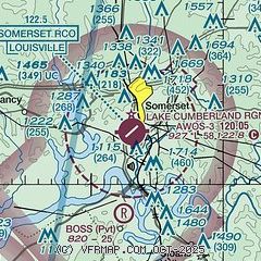
|
CAUTION: Diagram may not be current

| Airport distance calculator |
|---|
|
|
| Sunrise and sunset |
|---|
|
Times for 28-Dec-2025
| | Local
(UTC-5) | | Zulu
(UTC) |
|---|
| Morning civil twilight | | 07:23 | | 12:23 |
| Sunrise | | 07:52 | | 12:52 |
| Sunset | | 17:28 | | 22:28 |
| Evening civil twilight | | 17:57 | | 22:57 |
|
| Current date and time |
|---|
| Zulu (UTC) | 28-Dec-2025 21:28:14 |
|---|
| Local (UTC-5) | 28-Dec-2025 16:28:14 |
|---|
|
| METAR |
|---|
| KSME | 282115Z AUTO 23013G29KT 10SM BKN042 22/14 A2978 RMK AO2
|
KEKQ
17nm SW | 282056Z AUTO 22016G29KT 10SM BKN040 21/14 A2983 RMK AO2 PK WND 21033/1957 SLP094 6//// T02110139 55014 PNO $
|
|
| TAF |
|---|
| KSME | 281742Z 2818/2918 20013G26KT P6SM BKN035 FM282100 21015G30KT P6SM BKN040 PROB30 2900/2905 4SM -SHRA OVC015 FM290500 22017G36KT 6SM -SHRA OVC021 FM290700 27018G34KT 6SM -SHRA OVC013 FM290900 27015G26KT P6SM OVC016
|
|
| NOTAMs |
|---|
NOTAMs are issued by the DoD/FAA and will open in a separate window not controlled by AirNav.
|
|


