FAA INFORMATION EFFECTIVE 16 APRIL 2026
Location
| FAA Identifier: | SNS |
| Lat/Long: | 36-39-44.6790N 121-36-25.7530W
36-39.744650N 121-36.429217W
36.6624108,-121.6071536
(estimated) |
| Elevation: | 84.4 ft. / 25.7 m (surveyed) |
| Variation: | 13E (2020) |
| From city: | 3 miles SE of SALINAS, CA |
| Time zone: | UTC -7 (UTC -8 during Standard Time) |
| Zip code: | 93905 |
Airport Operations
| Airport use: | Open to the public |
| Activation date: | 06/1942 |
| Control tower: | yes |
| ARTCC: | OAKLAND CENTER |
| FSS: | OAKLAND FLIGHT SERVICE STATION |
| NOTAMs facility: | SNS (NOTAM-D service available) |
| Attendance: | CONTINUOUS |
| Pattern altitude: | 884.4 ft. MSL |
| Wind indicator: | lighted |
| Segmented circle: | no |
| Lights: | WHEN ATCT CLSD ACTVT MALSR RWY 31; REIL RWY 13 & 26; PAPI RWY 31; HIRL RWY 13/31; MIRL RWY 08/26; H1 - CTAF. VASI RWY 08, 13, & 26 OPR CONSLY. |
| Beacon: | white-green (lighted land airport)
Operates sunset to sunrise. |
Airport Communications
| CTAF: | 119.525 |
| UNICOM: | 123.0 |
| ATIS: | 124.85 |
| WX ASOS: | PHONE 831-422-2830 |
| SALINAS GROUND: | 121.7 [0600-1900 OCT-MAR; 0500-1900 APR-SEP] |
| SALINAS TOWER: | 119.525 239.3 [0600-1900 OCT-MAR; 0500-1900 APR-SEP] |
| NORCAL APPROACH: | 133.0 ;001-135 MRY |
| NORCAL DEPARTURE: | 133.0 ;001-135 MRY |
| CLASS C: | 133.0 ;001-135 MRY |
| IC: | 133.0 ;001-135 MRY |
| WX AWOS-3PT at OAR (8 nm W): | 134.025 (831-384-2967) |
| WX ASOS at MRY (12 nm W): | PHONE 831-643-6841 |
| WX AWOS-3 at CVH (17 nm NE): | 120.425 (831-636-4394) |
| WX ASOS at WVI (19 nm NW): | 132.275 (831-724-8794) |
Nearby radio navigation aids
| VOR radial/distance | | VOR name | | Freq | | Var |
|---|
| SNS at field | | SALINAS VORTAC | | 117.30 | | 17E |
| BSRr347/28.9 | | BIG SUR VORTAC | | 114.00 | | 16E |
| PXNr249/40.0 | | PANOCHE VORTAC | | 112.60 | | 16E |
Airport Services
| Fuel available: | 100LL JET-A |
| Parking: | hangars and tiedowns |
| Airframe service: | MAJOR |
| Powerplant service: | MAJOR |
| Bottled oxygen: | HIGH |
| Bulk oxygen: | NONE |
Runway Information
Runway 8/26
| Dimensions: | 6004 x 150 ft. / 1830 x 46 m |
| Surface: | asphalt, in good condition |
| Weight bearing capacity: | | Single wheel: | 80.0 | | Double wheel: | 136.0 | | Double tandem: | 244.0 |
|
| Runway edge lights: | medium intensity |
| RUNWAY 8 | | RUNWAY 26 |
| Latitude: | 36-39.774943N | | 36-39.657248N |
| Longitude: | 121-37.112477W | | 121-35.893150W |
| Elevation: | 69.6 ft. | | 83.8 ft. |
| Traffic pattern: | right | | left |
| Runway heading: | 084 magnetic, 097 true | | 264 magnetic, 277 true |
| Displaced threshold: | 396 ft. | | no |
| Markings: | nonprecision, in good condition | | nonprecision, in good condition |
| Visual slope indicator: | 2-box VASI on left (3.00 degrees glide path) | | 2-box VASI on left (3.00 degrees glide path) |
| Runway end identifier lights: | no | | yes |
| Touchdown point: | yes, no lights | | yes, no lights |
Runway 13/31
| Dimensions: | 4825 x 150 ft. / 1471 x 46 m
200 FT ASPH STWY RY 31. |
| Surface: | asphalt, in good condition |
| Weight bearing capacity: | | Single wheel: | 120.0 | | Double wheel: | 235.0 | | Double tandem: | 401.0 | | Dual double tandem: | 935.0 |
|
| Runway edge lights: | high intensity |
| RUNWAY 13 | | RUNWAY 31 |
| Latitude: | 36-40.116580N | | 36-39.443682N |
| Longitude: | 121-36.600470W | | 121-36.074860W |
| Elevation: | 84.4 ft. | | 82.0 ft. |
| Traffic pattern: | left | | right |
| Runway heading: | 135 magnetic, 148 true | | 315 magnetic, 328 true |
| Markings: | precision, in good condition | | precision, in good condition |
| Visual slope indicator: | 4-box VASI on left (3.00 degrees glide path) | | 2-light PAPI on left (3.00 degrees glide path) |
| RVR equipment: | rollout | | touchdown |
| Approach lights: | | | MALSR: 1,400 foot medium intensity approach lighting system with runway alignment indicator lights |
| Runway end identifier lights: | yes | | no |
| Touchdown point: | yes, no lights | | yes, no lights |
| Instrument approach: | | | ILS |
| Obstructions: | 45 ft. trees, 1733 ft. from runway, 310 ft. right of centerline, 34:1 slope to clear | | none |
Helipad H1
| Dimensions: | 90 x 90 ft. / 27 x 27 m |
| Surface: | asphalt/concrete/aggregate friction seal coat |
| Runway edge lights: | FLD |
| Latitude: | 36-39.956833N | | |
| Longitude: | 121-36.608000W | | |
| Elevation: | 78.0 ft. | | |
| Traffic pattern: | left | | left |
Airport Ownership and Management from official FAA records
| Ownership: | Publicly-owned |
| Owner: | CITY OF SALINAS
200 LINCOLN AVE
SALINAS, CA 93901
Phone 831-758-7214 |
| Manager: | MATT NELSON
30 MORTENSEN AVE
SALINAS, CA 93905
Phone 831-758-7214
EARLP@CI.SALINAS.CA.US |
Additional Remarks
| - | PORTIONS OF TWY B BETWEEN D & N LIMITED ATCT SERVICES PROVIDED |
| - | 6 FT TALL SECURITY FENCE 400 FT PRIOR TO RY 13 THLD ON CNTRLN AND STEEPLY DESCENDING TERRAIN 350 FT PRIOR TO RY 31 THLD ON CNTRLN BOTH IN RY 13/31 SAFETY AREA. |
| - | FOR CD WHEN ATCT IS CLSD CTC NORCAL APCH AT 916-361-3748. |
Instrument Procedures
NOTE: All procedures below are presented as PDF files. If you need a reader for these files, you should download the free Adobe Reader.NOT FOR NAVIGATION. Please procure official charts for flight.
FAA instrument procedures published for use from 16 April 2026 at 0901Z to 14 May 2026 at 0900Z.
IAPs - Instrument Approach Procedures |
|---|
| ILS RWY 31 | |
download (434KB) |
| RNAV (GPS) RWY 08 | |
download (291KB) |
| RNAV (GPS) RWY 13 | |
download (268KB) |
| RNAV (GPS) Y RWY 31 | |
download (423KB) |
| RNAV (GPS) Z RWY 31 | |
download (400KB) |
| LOC RWY 31 | |
download (453KB) |
| VOR RWY 13 | |
download (278KB) |
| NOTE: Special Alternate Minimums apply | |
download (139KB) |
Departure Procedures |
|---|
| SALINAS THREE | |
download (151KB) |
| NOTE: Special Take-Off Minimums/Departure Procedures apply | |
download (348KB) |
Other nearby airports with instrument procedures:
KOAR - Marina Municipal Airport (8 nm W)
KMRY - Monterey Regional Airport (12 nm W)
KCVH - Hollister Municipal Airport (17 nm NE)
KWVI - Watsonville Municipal Airport (19 nm NW)
E16 - San Martin Airport (25 nm N)
|
|

Road maps at:
MapQuest
Bing
Google
| Aerial photo |
|---|
WARNING: Photo may not be current or correct
 Photo courtesy of focalflight.com
Photo taken 18-Jun-2020
Photo courtesy of focalflight.com
Photo taken 18-Jun-2020
Do you have a better or more recent aerial photo of Salinas Municipal Airport that you would like to share? If so, please send us your photo.
|
| Sectional chart |
|---|
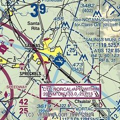
|
 Download PDF
of official airport diagram from the FAA
| Airport distance calculator |
|---|
|
|
| Sunrise and sunset |
|---|
|
Times for 08-May-2026
| | Local
(UTC-7) | | Zulu
(UTC) |
|---|
| Morning civil twilight | | 05:38 | | 12:38 |
| Sunrise | | 06:06 | | 13:06 |
| Sunset | | 20:00 | | 03:00 |
| Evening civil twilight | | 20:28 | | 03:28 |
|
| Current date and time |
|---|
| Zulu (UTC) | 08-May-2026 15:35:37 |
|---|
| Local (UTC-7) | 08-May-2026 08:35:37 |
|---|
|
| METAR |
|---|
| KSNS | 081453Z 26004KT 5SM BR OVC006 12/11 A3010 RMK AO2 SLP202 T01170106 53009
|
KOAR
8nm W | 134.025 831-384-2967
081515Z AUTO 00000KT 4SM BR OVC004 11/11 A3010 RMK AO2
|
KMRY
13nm W | 081454Z 04003KT 7SM OVC006 12/11 A3010 RMK AO2 SLP206 T01170106 53005
|
KCVH
17nm NE | 081515Z AUTO 00000KT 10SM OVC012 13/10 A3012 RMK A01
|
KWVI
18nm NW | 081453Z AUTO 00000KT 6SM BR OVC005 12/11 A3011 RMK AO2 SLP196 T01170106 53007
|
|
| TAF |
|---|
| KSNS | 081122Z 0812/0912 28008KT P6SM OVC008 FM081600 30004KT 4SM BR OVC010 FM081800 28010KT P6SM FEW015 FM082000 30013KT P6SM SKC FM090400 24007KT P6SM OVC010
|
KMRY
13nm W | 081122Z 0812/0912 23006KT P6SM OVC008 FM081600 25004KT P6SM FEW007 BKN015 FM081900 28008KT P6SM FEW015 FM090200 27006KT P6SM SCT012 FM090400 25005KT P6SM OVC010
|
|
| NOTAMs |
|---|
NOTAMs are issued by the DoD/FAA and will open in a separate window not controlled by AirNav.
|
|


