FAA INFORMATION EFFECTIVE 16 APRIL 2026
Location
| FAA Identifier: | SPF |
| Lat/Long: | 44-28-51.8000N 103-47-09.6000W
44-28.863333N 103-47.160000W
44.4810556,-103.7860000
(estimated) |
| Elevation: | 3933.1 ft. / 1198.8 m (surveyed) |
| Variation: | 11E (1990) |
| From city: | 3 miles E of SPEARFISH, SD |
| Time zone: | UTC -6 (UTC -7 during Standard Time) |
| Zip code: | 57783 |
Airport Operations
| Airport use: | Open to the public |
| Activation date: | 11/1937 |
| Control tower: | no |
| ARTCC: | DENVER CENTER |
| FSS: | HURON FLIGHT SERVICE STATION |
| NOTAMs facility: | SPF (NOTAM-D service available) |
| Attendance: | 0730-DUSK
FOR ATTENDANT AFT HRS CALL 605-642-2656/641-2787. |
| Wind indicator: | lighted |
| Segmented circle: | yes |
| Lights: | ACTVT MIRL RY 13/31; PAPI RYS 13 & 31 AND TWY A LGTS- CTAF. |
| Beacon: | white-green (lighted land airport)
Operates sunset to sunrise. |
Airport Communications
| CTAF/UNICOM: | 122.7 |
| WX AWOS-3: | 118.325 (605-642-8536) |
| ELLSWORTH APPROACH: | 119.5 [0500-0000] |
| ELLSWORTH DEPARTURE: | 119.5 [0500-0000] |
| WX AWOS-3P at 49B (18 nm E): | 119.275 (605-347-3356) |
- APCH/DEP CTL SVC PRVDD BY DENVER ARTCC (ZDV) ON FREQS 127.95/338.2 (RAPID CITY RCAG) WHEN ELLSWORTH APCH CTL (RCA) CLSD.
Airport Services
| Fuel available: | 100LL JET-A |
| Parking: | hangars and tiedowns |
| Airframe service: | MAJOR |
| Powerplant service: | MAJOR |
| Bottled oxygen: | HIGH |
| Bulk oxygen: | HIGH |
Runway Information
Runway 13/31
| Dimensions: | 6401 x 75 ft. / 1951 x 23 m |
| Surface: | asphalt, in good condition |
| Weight bearing capacity: | | Single wheel: | 33.0 | | Double wheel: | 45.0 |
|
| Runway edge lights: | medium intensity |
| RUNWAY 13 | | RUNWAY 31 |
| Latitude: | 44-29.447282N | | 44-28.700135N |
| Longitude: | 103-47.821110W | | 103-46.784117W |
| Elevation: | 3884.0 ft. | | 3895.1 ft. |
| Traffic pattern: | right | | left |
| Runway heading: | 124 magnetic, 135 true | | 304 magnetic, 315 true |
| Markings: | nonprecision, in good condition | | nonprecision, in good condition |
| Visual slope indicator: | 4-light PAPI on left (3.00 degrees glide path) | | 4-light PAPI on left (3.00 degrees glide path) |
| Runway end identifier lights: | no | | no |
| Touchdown point: | yes, no lights | | yes, no lights |
| Obstructions: | 98 ft. hill, 2160 ft. from runway, 380 ft. left of centerline, 20:1 slope to clear | | none |
Runway 8/26
| Dimensions: | 4003 x 100 ft. / 1220 x 30 m |
| Surface: | turf, in excellent condition |
| RUNWAY 8 | | RUNWAY 26 |
| Latitude: | 44-28.600015N | | 44-28.582370N |
| Longitude: | 103-47.615687W | | 103-46.696137W |
| Elevation: | 3932.8 ft. | | 3901.5 ft. |
| Traffic pattern: | left | | left |
| Runway heading: | 081 magnetic, 092 true | | 261 magnetic, 272 true |
| Runway end identifier lights: | no | | no |
| Touchdown point: | yes, no lights | | yes, no lights |
Runway 4/22
| Dimensions: | 1995 x 120 ft. / 608 x 37 m |
| Surface: | turf, in excellent condition |
| Runway edge markings: | RY 04/22 & RY 08/26 MARKED WITH BLACK & WHITE EDGE MARKERS. |
| RUNWAY 4 | | RUNWAY 22 |
| Latitude: | 44-28.620397N | | 44-28.850992N |
| Longitude: | 103-46.874093W | | 103-46.547758W |
| Elevation: | 3903.9 ft. | | 3866.9 ft. |
| Traffic pattern: | left | | left |
| Runway heading: | 034 magnetic, 045 true | | 214 magnetic, 225 true |
| Runway end identifier lights: | no | | no |
| Touchdown point: | yes, no lights | | yes, no lights |
| Obstructions: | 18 ft. road, 650 ft. from runway, 36:1 slope to clear | | 1 ft. fence, 150 ft. from runway |
Airport Ownership and Management from official FAA records
| Ownership: | Publicly-owned |
| Owner: | CITY OF SPEARFISH
625 NORTH FIFTH STREET
SPEARFISH, SD 57783
Phone 605-642-1333 |
| Manager: | CHANNING WAGNER
300 AVIATION PLACE
SPEARFISH, SD 57783
Phone 701-590-2828 |
Additional Remarks
| - | HIGH VOL OF ACFT OPRNG INVOF OF MT RUSHMORE AND CRAZY HORSE MONUMENTS AT OR BLW 7500 FT; PILOTS ARE ADVISED TO MNT 122.85 FOR TFC ADVISORIES. |
| - | COLD TEMPERATURE AIRPORT. ALTITUDE CORRECTION REQUIRED AT OR BELOW -30C. |
| - | IREG OPNS IN & OUT OF PVT AIRFIELD LOCATED APRXLY 3300 FT S OF ARPT; CHECK CTAF FREQ FOR STATUS. |
| - | RY 22 +4 FT FENCE 50 FT R 141 FT FM THLD & 50 FT L 175 FT FM THLD., |
| - | NO SNOW REMOVAL ON TURF RYS, CFM CONDS WITH AMGR, CALL 605-642-4112/2656. |
| - | ULTRALIGHT ACTIVITY ON & INVOF ARPT. |
| - | GCO AVBL ON FREQ 121.725 (4 CLICKS TO ELLSWORTH APPROACH AND 6 CLICKS TO DENVER CENTER) |
| - | FOR CD CTC ELLSWORTH APCH AT 605-385-6198, WHEN APCH CLSD CTC DENVER ARTCC AT 303-651-4257. |
Instrument Procedures
NOTE: All procedures below are presented as PDF files. If you need a reader for these files, you should download the free Adobe Reader.NOT FOR NAVIGATION. Please procure official charts for flight.
FAA instrument procedures published for use from 16 April 2026 at 0901Z to 14 May 2026 at 0900Z.
IAPs - Instrument Approach Procedures |
|---|
| RNAV (GPS) RWY 13 | |
download (234KB) |
| RNAV (GPS) RWY 31 | |
download (225KB) |
| NOTE: Special Alternate Minimums apply | |
download (151KB) |
|
|---|
| SWUNG TWO (OBSTACLE) (RNAV) | |
download (344KB) |
| NOTE: Special Take-Off Minimums/Departure Procedures apply | |
download (404KB) |
Other nearby airports with instrument procedures:
KEFC - Belle Fourche Municipal Airport (16 nm N)
49B - Sturgis Municipal Airport (18 nm E)
W43 - Hulett Municipal Airport (35 nm W)
KRCA - Ellsworth Air Force Base (36 nm SE)
KRAP - Rapid City Regional Airport (41 nm SE)
|
|

Road maps at:
MapQuest
Bing
Google
| Aerial photo |
|---|
WARNING: Photo may not be current or correct
 Photo by Andreas Lauschke
Photo taken 06-Oct-2024
looking northeast.
Photo by Andreas Lauschke
Photo taken 06-Oct-2024
looking northeast.
Do you have a better or more recent aerial photo of Black Hills Airport-Clyde Ice Field that you would like to share? If so, please send us your photo.
|
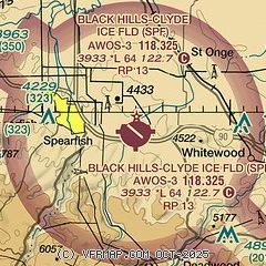
| Sectional chart |
|---|
|
| Airport distance calculator |
|---|
|
|
| Sunrise and sunset |
|---|
|
Times for 07-May-2026
| | Local
(UTC-6) | | Zulu
(UTC) |
|---|
| Morning civil twilight | | 05:05 | | 11:05 |
| Sunrise | | 05:38 | | 11:38 |
| Sunset | | 20:05 | | 02:05 |
| Evening civil twilight | | 20:38 | | 02:38 |
|
| Current date and time |
|---|
| Zulu (UTC) | 08-May-2026 02:37:00 |
|---|
| Local (UTC-6) | 07-May-2026 20:37:00 |
|---|
|
| METAR |
|---|
| KSPF | 080215Z AUTO 25009KT 10SM OVC080 13/04 A2987 RMK AO2
|
|
| TAF |
|---|
KRCA
37nm SE | 071900Z 0719/0901 VRB06KT 9999 FEW120 BKN250 QNH2980INS BECMG 0721/0722 12012G18KT 9000 -SHRA VCTS BKN080 OVC100CB QNH2979INS BECMG 0802/0803 28012KT 9999 NSW SCT080 BKN250 QNH2980INS BECMG 0814/0815 33015G35KT 9999 FEW250 520004 QNH2986INS BECMG 0821/0822 32009KT 9999 FEW100 QNH2981INS TX19/0721Z TN09/0812Z
|
KRAP
41nm SE | 071736Z 0718/0818 02006KT P6SM OVC090 PROB30 0720/0724 -TSRA SCT050CB BKN080 FM080900 31012KT P6SM SCT100
|
|
| NOTAMs |
|---|
NOTAMs are issued by the DoD/FAA and will open in a separate window not controlled by AirNav.
|
|


