FAA INFORMATION EFFECTIVE 16 APRIL 2026
Location
| FAA Identifier: | SSI |
| Lat/Long: | 31-09-07.0790N 081-23-27.8150W
31-09.117983N 081-23.463583W
31.1519664,-81.3910597
(estimated) |
| Elevation: | 18.9 ft. / 5.8 m (surveyed) |
| Variation: | 05W (2000) |
| From city: | 1 mile N of ST SIMONS ISLAND, GA |
| Time zone: | UTC -4 (UTC -5 during Standard Time) |
| Zip code: | 31522 |
Airport Operations
| Airport use: | Open to the public |
| Activation date: | 04/1940 |
| Control tower: | no |
| ARTCC: | JACKSONVILLE CENTER |
| FSS: | MACON FLIGHT SERVICE STATION |
| NOTAMs facility: | SSI (NOTAM-D service available) |
| Attendance: | 0700-2000 |
| Wind indicator: | lighted |
| Segmented circle: | yes |
| Lights: | ACTVT REIL RWY 04; HIRL RWY 04/22 & 16/34 - CTAF. |
| Beacon: | white-green (lighted land airport)
Operates sunset to sunrise. |
| International operations: | customs landing rights airport |
Airport Communications
| CTAF/UNICOM: | 123.05 |
| WX AWOS-3PT: | 120.025 (912-602-0972) |
| WX AWOS-3 at BQK (7 nm NW): | 124.175 (912-261-0531) |
- APCH/DEP SVC PRVDD BY JACKSONVILLE ARTCC (ZJX) ON FREQS 126.75/277.4 (BRUNSWICK RCAG).
Nearby radio navigation aids
| VOR radial/distance | | VOR name | | Freq | | Var |
|---|
| SSIr029/6.7 | | BRUNSWICK VORTAC | | 109.80 | | 04W |
Airport Services
| Fuel available: | 100LL JET-A JET-A+ |
| Parking: | hangars and tiedowns |
| Airframe service: | MAJOR |
| Powerplant service: | MINOR |
| Bottled oxygen: | HIGH/LOW |
| Bulk oxygen: | HIGH/LOW |
Runway Information
Runway 4/22
| Dimensions: | 5584 x 100 ft. / 1702 x 30 m |
| Surface: | asphalt/grooved, in good condition |
| Weight bearing capacity: | | PCN 38 /F/B/X/T | | Single wheel: | 45.0 | | Double wheel: | 60.0 |
|
| Runway edge lights: | high intensity |
| RUNWAY 4 | | RUNWAY 22 |
| Latitude: | 31-08.742470N | | 31-09.486563N |
| Longitude: | 081-23.936850W | | 081-23.305555W |
| Elevation: | 10.3 ft. | | 16.1 ft. |
| Traffic pattern: | left | | left |
| Runway heading: | 041 magnetic, 036 true | | 221 magnetic, 216 true |
| Displaced threshold: | 782 ft. | | 911 ft. |
| Declared distances: | TORA:5580 TODA:5580 ASDA:5580 LDA:4798 | | TORA:5580 TODA:5580 ASDA:5580 LDA:4671 |
| Markings: | nonprecision, in good condition | | nonprecision, in good condition |
| Visual slope indicator: | 2-light PAPI on left (4.00 degrees glide path) | | 2-light PAPI on left (4.00 degrees glide path) |
| Runway end identifier lights: | yes | | no |
| Touchdown point: | yes, no lights | | yes, no lights |
| Obstructions: | 15 ft. road, 215 ft. from runway, 256 ft. left of centerline
+6 FT FENCE, +32 FT POWER POLE, +12 FT BUSH 75-200 FT FROM END OF RWY 228-250 FT LEFT. | | 21 ft. bldg, 232 ft. from runway, 251 ft. right of centerline, 1:1 slope to clear
6 FT FENCE 190 FT RIGHT OF CNTRLN, 140 FT FROM E.O.R. |
Runway 16/34
| Dimensions: | 3313 x 75 ft. / 1010 x 23 m |
| Surface: | asphalt, in excellent condition |
| Weight bearing capacity: | | Single wheel: | 14.0 | | Double wheel: | 30.0 |
|
| Runway edge lights: | high intensity |
| RUNWAY 16 | | RUNWAY 34 |
| Latitude: | 31-09.369700N | | 31-08.877905N |
| Longitude: | 081-23.336543W | | 081-23.059307W |
| Elevation: | 18.0 ft. | | 11.9 ft. |
| Traffic pattern: | left | | left |
| Runway heading: | 159 magnetic, 154 true | | 339 magnetic, 334 true |
| Markings: | basic, in good condition | | basic, in good condition |
| Visual slope indicator: | 2-light PAPI on left (3.25 degrees glide path) | | 2-light PAPI on left (3.75 degrees glide path) |
| Touchdown point: | yes, no lights | | yes, no lights |
| Obstructions: | 30 ft. trees, 740 ft. from runway, 150 ft. right of centerline, 18:1 slope to clear | | 47 ft. trees, 845 ft. from runway, 150 ft. left of centerline, 13:1 slope to clear |
Airport Ownership and Management from official FAA records
| Ownership: | Publicly-owned |
| Owner: | GLYNN COUNTY - GLYNN CO. ARPT COMM.
295 AVIATION PARKWAY, SUITE 205
BRUNSWICK, GA 31525
Phone (912) 265-2070 |
| Manager: | ROBERT BURR
295 AVIATION PARKWAY, SUITE 205
BRUNSWICK, GA 31525
Phone 912-265-2070 |
Additional Remarks
| - | BIRDS AND WILDLIFE ON & INVOF ARPT. |
| - | PREF NOISE-ABATEMENT ARRIVAL FOR HEL TFC IS A STRAIGHT-IN TO RWY 34 THEN A MID-FIELD TURN TO LDG. ALL WHEELED HEL GND TAXI TO FINAL PRKG. |
| - | ADDITIONAL APT SAFETY BULLETINS POSTED AT WWW.FLYGCAIRPORTS.COM/SAFETY. |
| - | FOR CD CTC JACKSONVILLE ARTCC AT 904-845-1592. |
| - | FBO SVCS AVBL ON 130.65. |
| - | TRG FLTS ARE ENCOURAGED TO USE BRUNSWICK GOLDEN ISLES ARPT LCTD 7 NM NW OF ST. SIMONS ISLAND ARPT FOR OPS. |
| - | USE CTN DUE TO CONGESTED ASP WITH TURBINE, NONTURBINE, AND TRNG ACFT. BQK LOCATED 7NM NW. JEKYLL ISLAND AP 09J LOCATED 4NM S USING SAME CTAF FREQ 123.05. |
| - | RWY 22 PREF FOR LIGHT AND VRB WINDS OR CROSSWINDS. |
| - | ALL VFR ACFT ADHERE TO STD LH TFC PAT. |
| - | ACFT DEPARTING RWY 34 USE EXTRM CTN- APCH END OF RWY 04 NOT VSB FROM APCH END OF RWY 34. |
| - | ALL ARRIVALS AND DEPARTURES, INCLUDING ACFT FLYING INST APPROACHES, ARE REQSTD TO RPRT 10 MILES FROM THE AP, INTNS AND PSN REPORTS TO -ST SIMONS- CTAF 123.05. |
| - | PPR FOR SVC AND FUEL AFTER HRS CALL 912-638-8617. |
| - | ADJ RESIDENTIAL AREA TO THE SE AND SSW OF RWY 16/34 EXTREMELY NOISE SENSITIVE. |
Instrument Procedures
NOTE: All procedures below are presented as PDF files. If you need a reader for these files, you should download the free Adobe Reader.NOT FOR NAVIGATION. Please procure official charts for flight.
FAA instrument procedures published for use from 16 April 2026 at 0901Z to 14 May 2026 at 0900Z.
IAPs - Instrument Approach Procedures |
|---|
| RNAV (GPS) RWY 04 | |
download (250KB) |
| RNAV (GPS) RWY 22 | |
download (245KB) |
| VOR RWY 04 | |
download (239KB) |
| NOTE: Special Take-Off Minimums/Departure Procedures apply | |
download (424KB) |
Other nearby airports with instrument procedures:
09J - Jekyll Island Airport (5 nm S)
KBQK - Brunswick Golden Isles Airport (7 nm NW)
4J1 - Brantley County Airport (27 nm W)
KFHB - Fernandina Beach Municipal Airport (33 nm S)
KJES - Jesup-Wayne County Airport (35 nm NW)
|
|

Road maps at:
MapQuest
Bing
Google
| Aerial photo |
|---|
WARNING: Photo may not be current or correct
 Photo by Michael York
Photo taken 17-Feb-2010
Photo by Michael York
Photo taken 17-Feb-2010
Do you have a better or more recent aerial photo of St Simons Island Airport that you would like to share? If so, please send us your photo.
|
| Sectional chart |
|---|
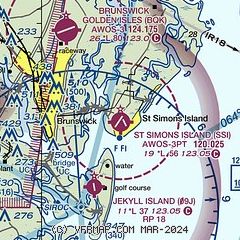
|
CAUTION: Diagram may not be current

| Airport distance calculator |
|---|
|
|
| Sunrise and sunset |
|---|
|
Times for 20-Apr-2026
| | Local
(UTC-4) | | Zulu
(UTC) |
|---|
| Morning civil twilight | | 06:28 | | 10:28 |
| Sunrise | | 06:53 | | 10:53 |
| Sunset | | 19:56 | | 23:56 |
| Evening civil twilight | | 20:21 | | 00:21 |
|
| Current date and time |
|---|
| Zulu (UTC) | 20-Apr-2026 16:42:41 |
|---|
| Local (UTC-4) | 20-Apr-2026 12:42:41 |
|---|
|
| METAR |
|---|
| KSSI | 201615Z AUTO 06010G18KT 030V090 10SM CLR 21/06 A3028 RMK AO2
|
KBQK
7nm NW | 201615Z AUTO 05013G19KT 10SM CLR 22/05 A3030 RMK AO2 T02220055
|
|
| TAF |
|---|
| KSSI | 201120Z 2012/2112 01011KT P6SM SCT250 FM201300 05018G28KT P6SM FEW250 FM202100 07012G20KT P6SM SKC FM210000 VRB05KT P6SM SKC
|
|
| NOTAMs |
|---|
NOTAMs are issued by the DoD/FAA and will open in a separate window not controlled by AirNav.
|
|


