FAA INFORMATION EFFECTIVE 09 JULY 2026
Location
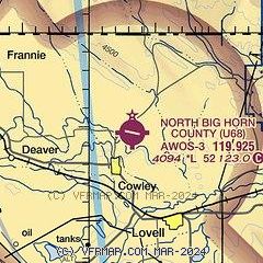
| FAA Identifier: | U68 |
| Lat/Long: | 44-54-42.0000N 108-26-43.8000W
44-54.700000N 108-26.730000W
44.9116667,-108.4455000
(estimated) |
| Elevation: | 4093.5 ft. / 1247.7 m (surveyed) |
| Variation: | 11E (2015) |
| From city: | 2 miles N of central business district of the associated city
(2 MILES N OF COWLEY.) |
| Time zone: | UTC -6 (UTC -7 during Standard Time) |
| Zip code: | 82420 |
Airport Operations
| Airport use: | Open to the public |
| Activation date: | 11/1937 |
| Control tower: | no |
| ARTCC: | SALT LAKE CITY CENTER |
| FSS: | CASPER FLIGHT SERVICE STATION |
| NOTAMs facility: | CPR (NOTAM-D service available) |
| Attendance: | IRREG
ATNDNC IS PERIODIC & UNSKED. FONE AHD FOR SVCS. FOR ATTENDANT AFT HRS CALL 307-250-7215 OR TEXT/CALL AMGR. |
| Wind indicator: | lighted |
| Segmented circle: | yes |
| Lights: | ACTVT MIRL RWY 09/27; PAPI RWY 09 & 27; REIL RWY 9 & 27- CTAF. |
| Beacon: | white-green (lighted land airport)
Operates sunset to sunrise. |
Airport Communications
| CTAF/UNICOM: | 123.0 |
| WX AWOS-3: | 119.925 (307-548-2560) |
| WX AWOS-3 at POY (15 nm W): | 119.275 (307-754-7093) |
- APCH/DEP CTL SVC PRVDD BY SALT LAKE ARTCC (ZLC) ON FREQS 133.25/285.6(BOYSEN RCAG).
Nearby radio navigation aids
| VOR radial/distance | | VOR name | | Freq | | Var |
|---|
| CODr038/28.2 | | CODY VOR/DME | | 111.80 | | 14E |
Airport Services
| Fuel available: | 100LL
100LL:SVC AVBL H24 VIA CREDIT CARD. |
| Parking: | tiedowns |
| Airframe service: | NONE |
| Powerplant service: | NONE |
| Bottled oxygen: | NONE |
| Bulk oxygen: | NONE |
Runway Information
Runway 9/27
| Dimensions: | 5200 x 75 ft. / 1585 x 23 m |
| Surface: | asphalt, in good condition |
| Weight bearing capacity: | |
| Runway edge lights: | medium intensity |
| RUNWAY 9 | | RUNWAY 27 |
| Latitude: | 44-54.841363N | | 44-54.608768N |
| Longitude: | 108-27.207205W | | 108-26.048423W |
| Elevation: | 4083.4 ft. | | 4093.5 ft. |
| Traffic pattern: | left | | left |
| Runway heading: | 095 magnetic, 106 true | | 275 magnetic, 286 true |
| Markings: | nonprecision, in good condition | | nonprecision, in good condition |
| Visual slope indicator: | 2-light PAPI on left (3.00 degrees glide path) | | 2-light PAPI on left (3.00 degrees glide path) |
| Runway end identifier lights: | yes | | yes |
| Touchdown point: | yes, no lights | | yes, no lights |
| Obstructions: | 8 ft. hill, 315 ft. from runway, 90 ft. right of centerline, 14:1 slope to clear | | 91 ft. hill, 3673 ft. from runway, 40 ft. left of centerline, 38:1 slope to clear |
Runway 16/34
| Dimensions: | 1866 x 65 ft. / 569 x 20 m |
| Surface: | dirt, in good condition |
| Runway edge markings: | 16/34 RWY END DELINATED BY +1 FT CONES. |
| RUNWAY 16 | | RUNWAY 34 |
| Latitude: | 44-54.782583N | | 44-54.479000N |
| Longitude: | 108-27.049898W | | 108-26.984820W |
| Elevation: | 4080.9 ft. | | 4083.2 ft. |
| Traffic pattern: | left | | left |
| Runway heading: | 161 magnetic, 172 true | | 341 magnetic, 352 true |
| Markings: | none, in good condition | | none, in good condition |
| Touchdown point: | yes, no lights | | yes, no lights |
Airport Ownership and Management from official FAA records
| Ownership: | Publicly-owned |
| Owner: | BIG HORN COUNTY
BOX 29
BASIN, WY 82410
Phone 307-568-2551 |
| Manager: | PAUL THUR
P. O. BOX 29, PO BOX 31
BASIN, WY 82410
Phone 307-337-8159 |
Additional Remarks
| - | RWY 16/34 SOFT WHEN WET. |
| - | REFLECTIVE MKRS MARK ENTRANCE TO TWY & TURNAROUND. |
| - | FOR CD CTC SALT LAKE ARTCC AT 801-320-2568. |
Instrument Procedures
NOTE: All procedures below are presented as PDF files. If you need a reader for these files, you should download the free Adobe Reader.NOT FOR NAVIGATION. Please procure official charts for flight.
FAA instrument procedures published for use from 09 July 2026 at 0901Z to 06 August 2026 at 0900Z.
IAPs - Instrument Approach Procedures |
|---|
| RNAV (GPS) RWY 09 | |
download (304KB) |
| NOTE: Special Take-Off Minimums/Departure Procedures apply | |
download (553KB) |
Other nearby airports with instrument procedures:
KPOY - Powell Municipal Airport (15 nm W)
KGEY - South Big Horn County Airport (28 nm SE)
KCOD - Yellowstone Regional Airport (34 nm SW)
6S8 - Laurel Municipal Airport (49 nm N)
KBIL - Billings Logan International Airport (54 nm N)
|
|

Road maps at:
MapQuest
Bing
Google
| Aerial photo |
|---|
WARNING: Photo may not be current or correct
 Photo by Ray Fey
Taken in 2004
looking northeast
Photo by Ray Fey
Taken in 2004
looking northeast
Do you have a better or more recent aerial photo of North Big Horn County Airport that you would like to share? If so, please send us your photo.
|
| Sectional chart |
|---|
|
| Airport distance calculator |
|---|
|
|
| Sunrise and sunset |
|---|
|
Times for 21-Jul-2026
| | Local
(UTC-6) | | Zulu
(UTC) |
|---|
| Morning civil twilight | | 05:13 | | 11:13 |
| Sunrise | | 05:49 | | 11:49 |
| Sunset | | 20:52 | | 02:52 |
| Evening civil twilight | | 21:27 | | 03:27 |
|
| Current date and time |
|---|
| Zulu (UTC) | 21-Jul-2026 07:49:45 |
|---|
| Local (UTC-6) | 21-Jul-2026 01:49:45 |
|---|
|
| METAR |
|---|
| KU68 | 210735Z AUTO 30011KT 10SM CLR 22/05 A3016 RMK AO2
|
KPOY
15nm W | 210715Z AUTO 32008KT CLR 18/03 A3024 RMK AO2 PWINO
|
|
| TAF |
|---|
KCOD
34nm SW | 210532Z 2106/2206 34010KT P6SM SCT100 BKN150 FM210900 VRB06KT P6SM FEW100 SCT150 FM211400 02010KT P6SM SCT100 BKN150 FM220000 33010KT P6SM VCSH SCT050 BKN070 PROB30 2200/2206 VRB20G35KT 3SM TSRA BKN070CB
|
|
| NOTAMs |
|---|
NOTAMs are issued by the DoD/FAA and will open in a separate window not controlled by AirNav.
|
|

