FAA INFORMATION EFFECTIVE 14 MAY 2026
Location
| FAA Identifier: | UDD |
| Lat/Long: | 33-44-54.3750N 116-16-29.3280W
33-44.906250N 116-16.488800W
33.7484375,-116.2748133
(estimated) |
| Elevation: | 73 ft. / 22.3 m (surveyed) |
| Variation: | 14E (1980) |
| From city: | 13 miles E of PALM SPRINGS, CA |
| Time zone: | UTC -7 (UTC -8 during Standard Time) |
| Zip code: | 92201 |
Airport Operations
| Airport use: | Open to the public |
| Activation date: | 10/1962 |
| Control tower: | no |
| ARTCC: | LOS ANGELES CENTER |
| FSS: | RIVERSIDE FLIGHT SERVICE STATION |
| NOTAMs facility: | RAL (NOTAM-D service available) |
| Attendance: | SEE RMKS
ATNDD OCT 1 THRU MAY 31 0600- 2000; JUNE 1 THRU SEPT 30 0600-1900. |
| Wind indicator: | lighted |
| Segmented circle: | yes |
| Lights: | VASI RWY 28; MIRL RWY 10/28 ON UNTIL 2200; AFTER 2200 ACTVT - CTAF. |
| Beacon: | white-green (lighted land airport)
Operates sunset to sunrise. |
| Landing fee: | yes, LNDG FEE BASED ON ACFT TYPE/SIZE. |
Airport Communications
| CTAF/UNICOM: | 122.8 |
| SOCAL APPROACH: | 135.275 |
| SOCAL DEPARTURE: | 135.275 |
| CLOWD STAR: | 126.7 |
| SBONO STAR: | 126.7 |
| SIZLR STAR: | 134.0 |
| WX ASOS at TRM (9 nm SE): | 118.325 (760-399-1494) |
| WX ASOS at PSP (13 nm NW): | PHONE 760-322-7597 |
Nearby radio navigation aids
| VOR radial/distance | | VOR name | | Freq | | Var |
|---|
| TRMr309/9.2 | | THERMAL VORTAC | | 116.20 | | 13E |
| PSPr120/10.6 | | PALM SPRINGS VORTAC | | 115.50 | | 13E |
| TNPr214/33.3 | | TWENTYNINE PALMS VORTAC | | 114.20 | | 15E |
| JLIr008/39.7 | | JULIAN VORTAC | | 113.75 | | 15E |
Airport Services
| Fuel available: | 100LL JET-A JET-A+ |
| Parking: | hangars and tiedowns |
| Airframe service: | MAJOR |
| Powerplant service: | MAJOR |
| Bottled oxygen: | LOW |
Runway Information
Runway 10/28
| Dimensions: | 5002 x 70 ft. / 1525 x 21 m |
| Surface: | asphalt, in good condition |
| Weight bearing capacity: | |
| Runway edge lights: | medium intensity |
| RUNWAY 10 | | RUNWAY 28 |
| Latitude: | 33-45.085350N | | 33-44.725883N |
| Longitude: | 116-16.932700W | | 116-16.044183W |
| Elevation: | 73.0 ft. | | 51.4 ft. |
| Traffic pattern: | left | | left |
| Runway heading: | 102 magnetic, 116 true | | 282 magnetic, 296 true |
| Displaced threshold: | no | | 300 ft. |
| Markings: | nonprecision, in good condition | | nonprecision, in good condition |
| Visual slope indicator: | | | 2-box VASI on left (3.00 degrees glide path) |
| Runway end identifier lights: | no | | yes |
| Touchdown point: | yes, no lights | | yes, no lights |
| Obstructions: | 6 ft. fence, 200 ft. from runway, 125 ft. left of centerline
+6' FENCE 125'L. | | 37 ft. road, 750 ft. from runway, 150 ft. right of centerline, 14:1 slope to clear
+6' FENCE 125'R. |
Airport Ownership and Management from official FAA records
| Ownership: | Privately-owned |
| Owner: | CPF BDA, LLC
3000 AIRWAY AVE, SUITE 200
COSTA MESA, CA 92626
Phone 949-476-2200 |
| Manager: | ANN GOODWYN
79880 AVE. 42
BERMUDA DUNES, CA 92203
Phone 760-345-2558 |
Additional Remarks
| - | NO AGRI FLIGHTS EXCP BY PPR ARPT MGR. |
| - | FOR CD CTC SOCAL APCH AT 800-448-3724. |
| - | FOR NOISE ABATEMENT PROCEDURES CALL AMGR (760) 345-2558. |
| - | ARPT CLSD TO TURBINE PWRD ACFT 2300-0600 LCL; EXCP MIL, LAW ENFORCEMENT, EMS ACFT. |
| - | PARL TWY CLSD ACFT WING SPAN GREATER THAN 68 FT. |
| - | 24 HR EMERG NR 760-609-4414. |
| - | FUEL AVBL 0600-2000. |
| - | ARINC FREQ 129.7 AVBL TO CTC FBO FOR SVCS ONLY |
Instrument Procedures
NOTE: All procedures below are presented as PDF files. If you need a reader for these files, you should download the free Adobe Reader.NOT FOR NAVIGATION. Please procure official charts for flight.
FAA instrument procedures published for use from 14 May 2026 at 0901Z to 11 June 2026 at 0900Z.
STARs - Standard Terminal Arrivals |
|---|
| CLOWD ONE | |
download (243KB) |
| RDBUL ONE (RNAV) | |
download (244KB) |
| SBONO ONE | |
download (253KB) |
| SIZLR FOUR (RNAV) | |
2 pages:
[1] [2] (349KB) |
IAPs - Instrument Approach Procedures |
|---|
| RNAV (GPS) RWY 10 | |
download (535KB) |
| RNAV (GPS) RWY 28 | |
download (398KB) |
| VOR-C | |
download (391KB) |
|
|---|
| BERMUDA DUNES ONE (OBSTACLE) | |
download (214KB) |
| NOTE: Special Take-Off Minimums/Departure Procedures apply | |
download (190KB) |
Other nearby airports with instrument procedures:
KTRM - Jacqueline Cochran Regional Airport (9 nm SE)
KPSP - Palm Springs International Airport (13 nm NW)
KTNP - Twentynine Palms Airport (28 nm NE)
L08 - Borrego Valley Airport (29 nm S)
KHMT - Hemet-Ryan Airport (37 nm W)
|
|

Road maps at:
MapQuest
Bing
Google
| Aerial photo |
|---|
WARNING: Photo may not be current or correct
 Photo courtesy of SkyviewImaging.com
Photo taken 01-Apr-2016
looking west.
Photo courtesy of SkyviewImaging.com
Photo taken 01-Apr-2016
looking west.
Do you have a better or more recent aerial photo of Bermuda Dunes Airport that you would like to share? If so, please send us your photo.
|
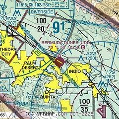
| Sectional chart |
|---|
|
| Airport distance calculator |
|---|
|
|
| Sunrise and sunset |
|---|
|
Times for 31-May-2026
| | Local
(UTC-7) | | Zulu
(UTC) |
|---|
| Morning civil twilight | | 05:08 | | 12:08 |
| Sunrise | | 05:37 | | 12:37 |
| Sunset | | 19:49 | | 02:49 |
| Evening civil twilight | | 20:17 | | 03:17 |
|
| Current date and time |
|---|
| Zulu (UTC) | 31-May-2026 17:10:40 |
|---|
| Local (UTC-7) | 31-May-2026 10:10:40 |
|---|
|
| METAR |
|---|
KTRM
9nm SE | 311652Z AUTO VRB04KT 10SM CLR 32/07 A2981 RMK AO2 SLP096 T03220067
|
KPSP
12nm W | 311653Z 00000KT 10SM CLR 32/06 A2985 RMK AO2 SLP104 T03170056
|
|
| TAF |
|---|
KTRM
9nm SE | 311125Z 3112/0112 VRB04KT P6SM SKC FM311800 14010KT P6SM SKC FM010400 33008KT P6SM SKC
|
KPSP
12nm W | 311125Z 3112/0112 VRB05KT P6SM SKC FM311800 12008KT P6SM SKC FM010100 32012G20KT P6SM SKC FM010700 VRB04KT P6SM SKC
|
|
| NOTAMs |
|---|
NOTAMs are issued by the DoD/FAA and will open in a separate window not controlled by AirNav.
|
|
FBO, Fuel Providers, and Aircraft Ground Support |
|---|
| | 
Business Name | |
Contact | |
Services / Description | |
Fuel Prices | |
Comments | |
|---|
| Dunes Air |
|
760-345-2558
[web site]
[email] |
|
Airport management, Aviation fuel, Aircraft ground handling, Oxygen service, Aircraft parking (ramp or tiedown), Hangars, Hangar leasing / sales, ...


|
|
|
|

4 read write
|
|
Alternatives at nearby airports
IMPORTANT: Note that the FBOs below are NOT at KUDD but at other nearby airports. Do not expect services from these FBOs to be available at KUDD. |
 |
|
ASRI 130.85
760-925-5876
toll-free 800-338-5876
[web site]
[email] |
|
At KTRM (Jacqueline Cochran Regional Airport), 9 miles SE
Desert Jet Center is the highest-rated FBO in all Palm Springs, renowned for unsurpassed customer service, safety, and premium amenities.
CAA preferred, we're a cost-effective and elevated alternative to KUDD, with NO SPECIAL EVENT FEES.
Desert Jet Center is closer to most events in La Quinta, Indio, Palm Desert and has an 8500-foot-long runway. Our entire team is NATA Safety 1st certified.
Our stunning 32,500-sq-ft FBO features a luxurious lobby, pilot lounges, and hangar for aircraft up to a Global 7000. We have on-site maintenance, aircraft detailing, rental cars, and courtesy crew cars
|
|
|
|
6 read write
|
|

|
| |
Aviation Businesses, Services, and Facilities |
|---|
| |
Business Name | |
Contact | |
Services / Description | |
Distance | |
Comments | |
|---|
|
|
|
949-590-9955
[web site]
[email] |
|
Cirrus Authorized Service Center. Oxygen service, TKS filling and piston aircraft maintenance conveniently located at the FBO. Aircraft weighing, propeller balancing, annuals and pre-buys. Enrolled in Part 145 drug testing program.
|
|
on airport |
|

write
|
|
|
|
|
760-394-8500
[web site]
[email] |
|
ALERT: Enjoy 50% OFF LABOR for Scheduled Maintenance at our FAA Part 145 Repair Station in Thermal until Sept. 30th. We also provide unscheduled maintenance and AOG support, ensuring precision, experience, and timeliness for your aircraft.

|
|
on airport |
|
write
|
|
|
|
|
702-389-2739
702-735-2739
[web site]
[email] |
|
Apex Aviation is a FAA certified Part 145 Repair Station (Certificate# 9VNR950B). We service Turbine, Turboprop, and Rotorcraft Aircraft. This unique "One-Stop Shop" saves the customer's time and money by providing aircraft maintenance, avionics, major repairs, and major modifications

|
|
on airport |
|
write
|
|
| |
Would you like to see your business listed on this page? |
|---|
| | If your business provides an interesting product or service to pilots, flight crews, aircraft, or users of the Bermuda Dunes Airport, you should consider listing it here. To start the listing process, click on the button below

|


