FAA INFORMATION EFFECTIVE 25 DECEMBER 2025
Location
| FAA Identifier: | VBG |
| Lat/Long: | 34-44-14.4120N 120-35-03.5252W
34-44.240200N 120-35.058753W
34.7373367,-120.5843126
(estimated) |
| Elevation: | 368 ft. / 112.2 m (surveyed) |
| Variation: | 12E (2020) |
| From city: | 7 miles NW of LOMPOC, CA |
| Time zone: | UTC -8 (UTC -7 during Daylight Saving Time) |
| Zip code: | 93437 |
Airport Operations
| Airport use: | Private use. Permission required prior to landing |
| Control tower: | yes |
| ARTCC: | LOS ANGELES CENTER |
| FSS: | HAWTHORNE FLIGHT SERVICE STATION
FSS-HAWTHORNE HHR-NOTAM KVBG |
| NOTAMs facility: | HHR (NOTAM-D service available) |
| Attendance: | 1600-0100Z++
CLSD SAT, SUN AND HOL. |
| Pattern altitude: | TFC PAT: OVERHEAD 2400, RECTANGULAR 1400 FT, LGT ACFT/COPTER 900 FT. |
| Wind indicator: | yes |
| Segmented circle: | no |
| Lights: | WHEN ATCT CLSD ACTVT ALS RWY 30; PAPI RWY 30; HIRL RWY 12/30 - CTAF. |
| Beacon: | white-green (lighted land airport)
BCN OTS. Operates sunset to sunrise. |
Airport Communications
| CTAF: | 124.95 |
| VANDENBERG GROUND: | 121.75 275.8 [0800-1700 EXCPT SAT-SUN & HOLIDAYS] |
| VANDENBERG TOWER: | 124.95 326.2 [0800-1700 EXCPT SAT-SUN & HOLIDAYS] |
| SANTA BARBARA APPROACH: | 124.15 |
| SANTA BARBARA DEPARTURE: | 124.15 |
| CLEARANCE DELIVERY: | 121.75 275.8 |
| COMD POST: | 126.2 311.0 321.0 |
| D-ATIS: | 133.125 257.975 |
| EMERG: | 121.5 243.0 |
| PMSV METRO: | 342.4 |
| PTD: | 126.2 372.2 |
| RANGE CTL: | 121.4 256.0 266.0 |
| WX AWOS-3PT at LPC (7 nm SE): | 133.875 (805-735-3075) |
| WX ASOS at SMX (12 nm NE): | 121.15 (209-210-1160) |
- APCH/DEP CTL SVC PRVDD BY LOS ANGELES ARTCC (ZLA) ON FREQS 119.05/269.5 (SAN LUIS OBISPO RCAG) WHEN SANTA BARBARA APCH CTL (SBA) CLSD.
- TWR (E) 124.95 326.2 REMARKS: SVC NOT PRVDD TO LOMPOC.
- (ATIS PHONE NR) C805-605-2847.
- WX SVC AVBL 0400-0400Z++ MON-SAT AT DSN 276-8022, C805-606-8022. AN/FMQ-23 AUTOMATED OBS SYS IN USE, AUGMENTED BY HUMAN WHEN NEC. DRG WX FLT CLOSURE OR EVAC, CTC COMD POST FOR WX FLT STBY PHONE NR.
Nearby radio navigation aids
| VOR radial/distance | | VOR name | | Freq | | Var |
|---|
| GLJr177/(13.3) | | GUADALUPE VOR | | 113.05 | | 16E |
| GVOr281/27.3 | | GAVIOTA VORTAC | | 113.80 | | 16E |
| MQOr148/32.1 | | MORRO BAY VORTAC | | 112.40 | | 16E |
Airport Services
| Fuel available: | A++
A++:SVC BY TRUCK ONLY; EXP SVC DELAYS. |
| Airframe service: | MAJOR |
| Powerplant service: | MAJOR |
| Bottled oxygen: | NONE |
| Bulk oxygen: | NONE |
Runway Information
Runway 12/30
| Dimensions: | 15000 x 200 ft. / 4572 x 61 m |
| Surface: | concrete, in good condition |
| Weight bearing capacity: | |
| Runway edge lights: | high intensity |
| RUNWAY 12 | | RUNWAY 30 |
| Latitude: | 34-45.137462N | | 34-43.342938N |
| Longitude: | 120-36.089193W | | 120-34.028315W |
| Elevation: | 238.0 ft. | | 368.0 ft. |
| Traffic pattern: | left | | left |
| Runway heading: | 125 magnetic, 137 true | | 305 magnetic, 317 true |
| Markings: | precision, in good condition | | precision, in good condition |
| Visual slope indicator: | 4-light PAPI on left (3.00 degrees glide path)
RWY 12 ILS AND PAPI GS NOT COINCIDENTAL. | | 4-light PAPI on left (3.00 degrees glide path) |
| Approach lights: | ALSF2: standard 2,400 foot high intensity approach lighting system with centerline sequenced flashers (category II or III)
RWY 12 APCH LGT SYS IS NSTD ALSF2 CONFIGN. | | ALSF2: standard 2,400 foot high intensity approach lighting system with centerline sequenced flashers (category II or III)
RWY 30 APCH LGT SYS IS NSTD ALSF2 CONFIGN. THLD LGTS ARE 16 FT FROM THE USBL PAVEMENT SFC. |
| Touchdown point: | yes, no lights | | yes, no lights |
| Instrument approach: | ILS | | ILS |
Airport Ownership and Management from official FAA records
| Ownership: | U.S. Air Force |
| Owner: | USAF
VANDENBERG AFB
LOMPOC, CA 93437 |
| Manager: | BASE OPERATIONS
VANDENGERG AFB
LOMPOC, CA 93437
Phone 805-606-6941 |
Additional Remarks
| - | RSTD - ACTIVATION OF AN/APS 145 RADAR OR SIMILAR RADAR SYSTEMS IS PROH WHILE IN R2516, R2517, R2534A AND R2534B. CTC TWR ON GND PRIOR TO ENG START, ENG START OR AFLD OPR NOT AUTH TIL CTC WITH TWR IS MADE. NO INT DEP BTN OFFL SS-SR. |
| - | CAUTION - UNCTL CIV ARPT TFC 7 NM SE. WHEN ARPT IS VMC ACFT WILL NOT EXCEED 1900' TIL CROS DEP END OF RWY TO AVOID OVERHEAD TFC PAT. HVY AND LARGE ACFT ARE REQ TO USE MIN TAXI PWR AND SHUT DOWN OR IDLE OUTBOARD ENG TO AVOID BLOWING FOREIGN OBJECT ONTO PAVEMENT. |
| - | CAUTION - PRK RAMP IS NOT MRK FOR C-17 ACFT. |
| - | REMARKS - FOR BASH INFO, SEE FLIP AP/1 SUPPLEMENTARY ARPT RMK. |
| - | RWY-LGTS: RWY 12 - SF. |
| - | TRAN ALERT: LTD FLEET SVC AVBL, CTC AM OPS. |
| - | MISC: ALL ACFT REQ FULL STOP AT VBG OR SUPPORTING VBG VIP MOVEMENT, CTC PTD (OT COMD POST) 30 MIN PRIOR TO LDG. ALTN AFLD RQR. AM OPS DSN 276-6941/42, C805-606-6941/42 FAX EXTN 6664. RWY 12-30 GROOVED. |
| - | MISC: EARLY/LATE ACFT ARR/DEP BEFORE/AFTER PUBL OR SKED AFLD OPERATING HRS SHALL EXP HOLDING WITH APCH CTL OR ARTCC TIL AFLD IS OPEN OR RON IF DEP. ACFT SHALL CTC COMD POST AT DSN 276-9961 PRIOR TO DEP WITH UPDATED ARR TIME. ENSURE PILOTS CK NOTAMS PRIOR TO DEP AS NOTAM WILL REFLECT AFLD HRS BASED ON APPROVED AFTER HRS REQ. CTC COMD POST 30 MIN OUT OR EARLIER. |
| - | TRAN ALERT: POTABLE WATER SVC UNAVBL. |
| - | RWY-LGTS: RWY 30 - SF. |
| - | LTD TOW CPBLTY; CTC AIRFIELD MGMT FOR SPECIFICS. |
| - | CAUTION: MKGS ON PRKG APRON FADED AND NON-RETROREFLECTIVE. |
| - | RSTD: ALPHA ROW ENG RUN-UP AREA UNAVBL. |
| - | CSTMS/AG/IMG: CUSTOMS UNAVBL. |
| - | CAUTION: ALTN HAZ CARGO PAD DOES NOT HAVE TIE DOWNS. |
| - | MISC: ANY CHANGE TO ARR/DEP TIME MUST BE COORD THRU COMD POST, RE-APVL IS RQR IF NEW ETA/ETD IS OUTSIDE OF AFLD HRS OF OPR. |
| - | CAUTION: OBST LGT ON WATER TWR LCTD 1.3 SM SW OF RWY 30 THLD O/S. |
| - | CAUTION: ACFT TIE-DOWNS UNAVBL. |
| - | MISC: COMSEC MTRL MUST BE STORED AT SLD 30 COMD POST DSN 276-9961, C805-606-9961. |
| - | CAUTION - USE EXTREME CTN FOR EXTENSIVE UAS OPS IN VCNTY. |
| - | RSTD: PPR AT LEAST 24 HR IN ADVN, BUT NO EARLIER THAN 5 BUS DAYS IN ADVN. SEND EMAIL TO 30OSS.OSAA@US.AF.MIL FOR PPR REQ FORM. AM OPS DSN 276-6941 OR C805-606-6941/6942 FAX EXTN 6664. ACFT OPS OUTSIDE OF PUBL AFLD OPRG HRS MUST BE APV AT LEAST 48 HRS IN ADV THRU AFLD MGMT. GRD SUPPORT SVC UNAVBL FOR ARR/DEP OPS OUTSIDE OF PUBL OR SKED AFLD OPRG HRS. |
| - | JASU - 4(A/M32A-86) 2(AM32-95). |
| - | MISC: AD WIND DRCTN INDCR OTS. |
| - | CAUTION: INADQT WIND INDICATORS (WINDCONES) FOR RWY 12/30. |
| - | FLUID - SP PRESAIR LPOX LOX LHNIT. |
| - | OIL - O-148-156. |
Instrument Procedures
NOTE: All procedures below are presented as PDF files. If you need a reader for these files, you should download the free Adobe Reader.NOT FOR NAVIGATION. Please procure official charts for flight.
FAA instrument procedures published for use from 25 December 2025 at 0901z to 22 January 2026 at 0900z.
IAPs - Instrument Approach Procedures |
|---|
| HI-ILS OR LOC/DME RWY 12 | |
download (209KB) |
| HI-ILS OR LOC/DME RWY 30 | |
download (212KB) |
| ILS OR LOC/DME RWY 12 | |
download (128KB) |
| ILS OR LOC/DME RWY 30 | |
download (129KB) |
| HI-TACAN RWY 12 | |
download (226KB) |
| HI-TACAN RWY 30 | |
download (205KB) |
| TACAN RWY 12 | |
download (108KB) |
| TACAN RWY 30 | |
download (121KB) |
Departure Procedures |
|---|
| GAVIOTA THREE | |
download (77KB) |
| VANDENBERG THREE | |
download (76KB) |
| NOTE: Special Take-Off Minimums/Departure Procedures apply | |
download (350KB) |
Other nearby airports with instrument procedures:
KLPC - Lompoc Airport (7 nm SE)
KSMX - Santa Maria Public Airport/Capt G Allan Hancock Field (12 nm NE)
KIZA - Santa Ynez Airport/Kunkle Field (26 nm E)
KSBP - San Luis Obispo County Regional Airport (30 nm N)
KSBA - Santa Barbara Municipal Airport (41 nm SE)
|
|

Road maps at:
MapQuest
Bing
Google
| Aerial photo |
|---|

|
| Sectional chart |
|---|
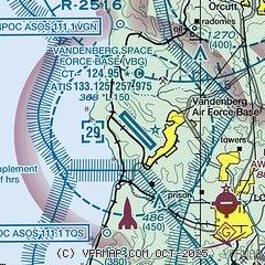
|
 Download PDF
of official airport diagram from the FAA
| Airport distance calculator |
|---|
|
|
| Sunrise and sunset |
|---|
|
Times for 30-Dec-2025
| | Local
(UTC-8) | | Zulu
(UTC) |
|---|
| Morning civil twilight | | 06:42 | | 14:42 |
| Sunrise | | 07:10 | | 15:10 |
| Sunset | | 17:00 | | 01:00 |
| Evening civil twilight | | 17:28 | | 01:28 |
|
| Current date and time |
|---|
| Zulu (UTC) | 30-Dec-2025 20:55:11 |
|---|
| Local (UTC-8) | 30-Dec-2025 12:55:11 |
|---|
|
| METAR |
|---|
KVBG
6nm S | 301955Z 00000KT 25SM SCT090 OVC120 22/06 A3010 RMK AO2A SLP195 T02170060
|
KLPC
7nm SE | 301951Z AUTO 00000KT 10SM OVC075 18/06 A3009 RMK AO2 SLP188 T01780056
|
KSMX
12nm NE | 301951Z 00000KT 10SM OVC085 18/07 A3010 RMK AO2 SLP193 T01830067 $
|
|
| TAF |
|---|
KVBG
6nm S | 292300Z 2923/3105 30006KT 9999 SKC QNH3010INS BECMG 3001/3002 23003KT 9999 SKC QNH3009INS BECMG 3015/3016 12006KT 9999 BKN100 QNH3012INS BECMG 3018/3019 16009KT 9999 BKN100 QNH3004INS BECMG 3100/3101 09006KT 9999 BKN060 QNH3001INS TX20/3021Z TN07/3012Z LAST NO AMDS AFT 3000 NEXT 3014
|
KSMX
12nm NE | 301728Z 3018/3118 VRB03KT P6SM BKN150 FM301900 05005KT P6SM OVC100 FM310100 VRB03KT P6SM OVC100 PROB30 3110/3115 -SHRA OVC050 FM311500 05005KT 6SM -RA BR OVC050
|
|
| NOTAMs |
|---|
NOTAMs are issued by the DoD/FAA and will open in a separate window not controlled by AirNav.
|
|


