FAA INFORMATION EFFECTIVE 14 MAY 2026
Location
| FAA Identifier: | VDI |
| Lat/Long: | 32-11-33.8000N 082-22-16.2000W
32-11.563333N 082-22.270000W
32.1927222,-82.3711667
(estimated) |
| Elevation: | 274.3 ft. / 83.6 m (surveyed) |
| Variation: | 06W (2020) |
| From city: | 3 miles SE of VIDALIA, GA |
| Time zone: | UTC -4 (UTC -5 during Standard Time) |
| Zip code: | 30436 |
Airport Operations
| Airport use: | Open to the public |
| Activation date: | 05/1943 |
| Control tower: | no |
| ARTCC: | JACKSONVILLE CENTER |
| FSS: | MACON FLIGHT SERVICE STATION |
| NOTAMs facility: | VDI (NOTAM-D service available) |
| Attendance: | 0800-1800 |
| Wind indicator: | lighted |
| Segmented circle: | no |
| Lights: | HIRL RWY 07/25 PRESET MED INTS DUSK-2300. AFTER 2300 ACTVT - CTAF. ACTVT MALSR RWY 25; REIL RWY 07 - CTAF. PAPI RWY 07 & 25 OPR CONSLY. |
| Beacon: | white-green (lighted land airport)
Operates sunset to sunrise. |
Airport Communications
| CTAF/UNICOM: | 122.8 |
| WX AWOS-3: | 119.925 (912-538-0219) |
| WX AWOS-3PT at RVJ (14 nm SE): | 128.325 (912-557-0011) |
| WX AWOS-3PT at MHP (18 nm NE): | 120.3 (912-685-2729) |
- APCH/DEP SVC PRVDD BY JACKSONVILLE ARTCC ON FREQS 127.575/269.025 (ALMA RCAG).
Nearby radio navigation aids
| VOR radial/distance | | VOR name | | Freq | | Var |
|---|
| DBNr139/32.2 | | DUBLIN VORTAC | | 113.10 | | 05W |
| NDB name | | Hdg/Dist | | Freq | | Var | | ID |
|---|
| ONYUN | | 250/4.2 | | 372 | | 06W | | UQN | ..- --.- -. |
| BULLO | | 255/38.3 | | 407 | | 05W | | BZQ | -... --.. --.- |
| EASTMAN | | 089/39.9 | | 366 | | 04W | | EZM | . --.. -- |
Airport Services
| Fuel available: | 100LL JET-A+
100LL:FUEL 24 HR CREDIT CARD SVC AVBL. |
| Parking: | tiedowns |
| Airframe service: | MINOR |
| Powerplant service: | MINOR |
| Bottled oxygen: | NONE |
| Bulk oxygen: | NONE |
Runway Information
Runway 7/25
| Dimensions: | 6002 x 100 ft. / 1829 x 30 m |
| Surface: | concrete, in good condition |
| Weight bearing capacity: | | Single wheel: | 30.0 | | Double wheel: | 48.0 | | Double tandem: | 85.0 |
|
| Runway edge lights: | high intensity |
| RUNWAY 7 | | RUNWAY 25 |
| Latitude: | 32-11.256910N | | 32-11.709572N |
| Longitude: | 082-22.755317W | | 082-21.720032W |
| Elevation: | 272.4 ft. | | 268.9 ft. |
| Traffic pattern: | left | | left |
| Runway heading: | 069 magnetic, 063 true | | 249 magnetic, 243 true |
| Markings: | precision, in fair condition | | precision, in fair condition |
| Visual slope indicator: | 4-light PAPI on left (3.00 degrees glide path) | | 4-light PAPI on left (3.00 degrees glide path) |
| Approach lights: | | | MALSR: 1,400 foot medium intensity approach lighting system with runway alignment indicator lights |
| Runway end identifier lights: | yes | | no |
| Touchdown point: | yes, no lights | | yes, no lights |
| Instrument approach: | | | ILS |
| Obstructions: | 31 ft. trees, 290 ft. from runway, 490 ft. right of centerline, 2:1 slope to clear | | 19 ft. trees, 575 ft. from runway, 230 ft. left of centerline, 19:1 slope to clear |
Runway 14/32
| Dimensions: | 5002 x 75 ft. / 1525 x 23 m |
| Surface: | concrete, in good condition |
| Weight bearing capacity: | | Single wheel: | 30.0 | | Double wheel: | 48.0 | | Double tandem: | 85.0 |
|
| RUNWAY 14 | | RUNWAY 32 |
| Latitude: | 32-11.933890N | | 32-11.386075N |
| Longitude: | 082-22.670865W | | 082-21.945607W |
| Elevation: | 271.7 ft. | | 272.1 ft. |
| Traffic pattern: | left | | left |
| Runway heading: | 138 magnetic, 132 true | | 318 magnetic, 312 true |
| Markings: | nonprecision, in fair condition | | nonprecision, in fair condition |
| Touchdown point: | yes, no lights | | yes, no lights |
| Obstructions: | 27 ft. trees, 339 ft. from runway, 262 ft. right of centerline, 5:1 slope to clear | | 42 ft. trees, 724 ft. from runway, 240 ft. left of centerline, 12:1 slope to clear |
Airport Ownership and Management from official FAA records
| Ownership: | Publicly-owned |
| Owner: | CITY OF VIDALIA
CITY HALL PO BOX 280
VIDALIA, GA 30474
Phone 912-537-7661 |
| Manager: | BILLY RAGAN
2921 AIRPORT ROAD
VIDALIA, GA 30474
Phone 912-537-3979 |
Additional Remarks
| - | FOR CD CTC JACKSONVILLE ARTCC AT 904-845-1592. |
Instrument Procedures
NOTE: All procedures below are presented as PDF files. If you need a reader for these files, you should download the free Adobe Reader.NOT FOR NAVIGATION. Please procure official charts for flight.
FAA instrument procedures published for use from 14 May 2026 at 0901Z to 11 June 2026 at 0900Z.
IAPs - Instrument Approach Procedures |
|---|
| ILS OR LOC RWY 25 | |
download (238KB) |
| RNAV (GPS) RWY 07 | |
download (256KB) |
| RNAV (GPS) RWY 25 | |
download (247KB) |
| NOTE: Special Alternate Minimums apply | |
download (48KB) |
| NOTE: Special Take-Off Minimums/Departure Procedures apply | |
download (286KB) |
Other nearby airports with instrument procedures:
KRVJ - Swinton Smith Field at Reidsville Municipal Airport (14 nm SE)
KMHP - John Edwin Jones Sr Field/Metter Municipal Airport (18 nm NE)
KAZE - Hazlehurst Airport (23 nm SW)
KSBO - East Georgia Regional Airport (25 nm N)
KCWV - Claxton-Evans County Airport (25 nm E)
|
|

Road maps at:
MapQuest
Bing
Google
| Aerial photo |
|---|
WARNING: Photo may not be current or correct

Do you have a better or more recent aerial photo of Vidalia Regional Airport that you would like to share? If so, please send us your photo.
|
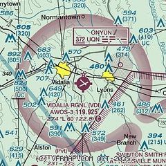
| Sectional chart |
|---|
|
| Airport distance calculator |
|---|
|
|
| Sunrise and sunset |
|---|
|
Times for 27-May-2026
| | Local
(UTC-4) | | Zulu
(UTC) |
|---|
| Morning civil twilight | | 05:59 | | 09:59 |
| Sunrise | | 06:26 | | 10:26 |
| Sunset | | 20:27 | | 00:27 |
| Evening civil twilight | | 20:55 | | 00:55 |
|
| Current date and time |
|---|
| Zulu (UTC) | 28-May-2026 03:23:14 |
|---|
| Local (UTC-4) | 27-May-2026 23:23:14 |
|---|
|
| METAR |
|---|
| KVDI | 280235Z AUTO 18006KT 10SM CLR 26/22 A3003 RMK AO2
|
KRVJ
14nm SE | 280235Z AUTO 16007KT 10SM CLR 24/22 A3004 RMK AO2 T02450217
|
KMHP
18nm NE | 280235Z AUTO 00000KT 10SM SCT036 SCT042 26/23 A3004 RMK AO2 T02560227
|
|
| NOTAMs |
|---|
NOTAMs are issued by the DoD/FAA and will open in a separate window not controlled by AirNav.
|
|


