FAA INFORMATION EFFECTIVE 14 MAY 2026
Location
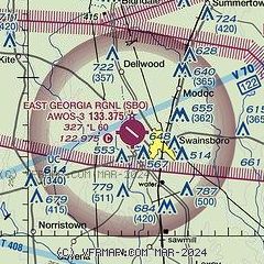
| FAA Identifier: | SBO |
| Lat/Long: | 32-36-32.9000N 082-22-11.8000W
32-36.548333N 082-22.196667W
32.6091389,-82.3699444
(estimated) |
| Elevation: | 327.2 ft. / 99.7 m (surveyed) |
| Variation: | 06W (2015) |
| From city: | 2 miles NW of SWAINSBORO, GA |
| Time zone: | UTC -4 (UTC -5 during Standard Time) |
| Zip code: | 30401 |
Airport Operations
| Airport use: | Open to the public |
| Activation date: | 06/1942 |
| Control tower: | no |
| ARTCC: | ATLANTA CENTER |
| FSS: | MACON FLIGHT SERVICE STATION |
| NOTAMs facility: | MCN (NOTAM-D service available) |
| Attendance: | MON-SAT 0800-1700
AFT HRS & SUNDAY PHONE 803-530-3124. |
| Wind indicator: | lighted |
| Segmented circle: | yes |
| Lights: | ACTVT PAPI RWY 14; HIRL RWY 14/32 - CTAF. |
| Beacon: | white-green (lighted land airport)
Operates sunset to sunrise. |
| Landing fee: | no, ONLY CHARGE FOR PART 135 OPS. |
Airport Communications
| CTAF/UNICOM: | 122.975 |
| WX AWOS-3: | 133.375 (478-237-8437) |
- APCH/DEP SVC PRVDD BY ATLANTA ARTCC ON FREQS 127.95/343.75 (MILLEN RCAG).
Nearby radio navigation aids
| VOR radial/distance | | VOR name | | Freq | | Var |
|---|
| DBNr088/23.4 | | DUBLIN VORTAC | | 113.10 | | 05W |
| NDB name | | Hdg/Dist | | Freq | | Var | | ID |
|---|
| ONYUN | | 357/23.4 | | 372 | | 06W | | UQN | ..- --.- -. |
| BULLO | | 293/37.6 | | 407 | | 05W | | BZQ | -... --.. --.- |
Airport Services
| Fuel available: | 100LL JET-A JET-A+
100LL:FUEL IS SELF SERVICE AFTER HRS. |
| Parking: | hangars and tiedowns |
| Airframe service: | MAJOR |
| Powerplant service: | MAJOR |
| Bottled oxygen: | HIGH/LOW |
| Bulk oxygen: | NONE |
Runway Information
Runway 14/32
| Dimensions: | 6021 x 100 ft. / 1835 x 30 m |
| Surface: | asphalt, in good condition |
| Weight bearing capacity: | | Single wheel: | 45.0 | | Double wheel: | 65.0 | | Double tandem: | 120.0 |
|
| Runway edge lights: | high intensity |
| RUNWAY 14 | | RUNWAY 32 |
| Latitude: | 32-36.863718N | | 32-36.232143N |
| Longitude: | 082-22.649090W | | 082-21.743905W |
| Elevation: | 324.0 ft. | | 322.0 ft. |
| Traffic pattern: | left | | left |
| Runway heading: | 135 magnetic, 129 true | | 315 magnetic, 309 true |
| Markings: | precision, in fair condition | | nonprecision, in fair condition |
| Visual slope indicator: | 4-light PAPI on left (3.00 degrees glide path) | | |
| Touchdown point: | yes, no lights | | yes, no lights |
| Instrument approach: | ILS/DME | | |
| Obstructions: | 43 ft. trees, 1445 ft. from runway, 648 ft. left of centerline, 28:1 slope to clear | | 5 ft. bldg, lighted, 226 ft. from runway, 468 ft. right of centerline, 5:1 slope to clear
6 FT FENCE AND VEHICLES LOCATED 400 FT RIGHT 0-200 FT FROM THR. |
Airport Ownership and Management from official FAA records
| Ownership: | Publicly-owned |
| Owner: | CITY OF SWAINSBORO
101 WEST MAIN STREET
SWAINSBORO, GA 30401
Phone 478-237-7025 |
| Manager: | KEN WARNOCK
102 SOUTH MAIN STREET
SWAINSBORO, GA 30401
Phone 478-237-5882 |
Additional Remarks
| - | DEER ON & INVOF ARPT. |
| - | GEESE ON AND INVOF ARPT. |
| - | FOR CD CTC ATLANTA ARTCC AT 770-210-7692. |
Instrument Procedures
NOTE: All procedures below are presented as PDF files. If you need a reader for these files, you should download the free Adobe Reader.NOT FOR NAVIGATION. Please procure official charts for flight.
FAA instrument procedures published for use from 14 May 2026 at 0901Z to 11 June 2026 at 0900Z.
IAPs - Instrument Approach Procedures |
|---|
| ILS OR LOC RWY 14 | |
download (244KB) |
| RNAV (GPS) RWY 14 | |
download (254KB) |
| RNAV (GPS) RWY 32 | |
download (248KB) |
| NOTE: Special Alternate Minimums apply | |
download (158KB) |
| NOTE: Special Take-Off Minimums/Departure Procedures apply | |
download (189KB) |
Other nearby airports with instrument procedures:
KMHP - John Edwin Jones Sr Field/Metter Municipal Airport (20 nm SE)
2J3 - Louisville Municipal Airport (23 nm N)
KVDI - Vidalia Regional Airport (25 nm S)
2J5 - Millen Airport (27 nm NE)
KDBN - W H 'Bud' Barron Airport (31 nm W)
|
|

Road maps at:
MapQuest
Bing
Google
| Aerial photo |
|---|
WARNING: Photo may not be current or correct
 Photo by Jerry N. Cadle
Taken in October 2008
Photo by Jerry N. Cadle
Taken in October 2008
Do you have a better or more recent aerial photo of East Georgia Regional Airport that you would like to share? If so, please send us your photo.
|
| Sectional chart |
|---|
|
| Airport distance calculator |
|---|
|
|
| Sunrise and sunset |
|---|
|
Times for 28-May-2026
| | Local
(UTC-4) | | Zulu
(UTC) |
|---|
| Morning civil twilight | | 05:57 | | 09:57 |
| Sunrise | | 06:25 | | 10:25 |
| Sunset | | 20:29 | | 00:29 |
| Evening civil twilight | | 20:56 | | 00:56 |
|
| Current date and time |
|---|
| Zulu (UTC) | 28-May-2026 18:24:32 |
|---|
| Local (UTC-4) | 28-May-2026 14:24:32 |
|---|
|
| METAR |
|---|
| KSBO | 281755Z 10SM SCT029 SCT033 SCT048 30/21 A2998 RMK AO2
|
|
| TAF |
|---|
KAGS
50nm NE | 281730Z 2818/2918 28007KT P6SM BKN040 PROB30 2819/2824 2SM -TSRA BR BKN035CB FM290200 VRB03KT P6SM SCT070 BKN120 TEMPO 2907/2911 3SM BR SCT002 FM291400 07006KT P6SM SCT045 BKN100
|
|
| NOTAMs |
|---|
NOTAMs are issued by the DoD/FAA and will open in a separate window not controlled by AirNav.
|
|


