FAA INFORMATION EFFECTIVE 16 APRIL 2026
Location
| FAA Identifier: | VPZ |
| Lat/Long: | 41-27-14.3000N 087-00-25.5000W
41-27.238333N 087-00.425000W
41.4539722,-87.0070833
(estimated) |
| Elevation: | 770.3 ft. / 234.8 m (surveyed) |
| Variation: | 02W (1985) |
| From city: | 1 mile SE of VALPARAISO, IN |
| Time zone: | UTC -5 (UTC -6 during Standard Time) |
| Zip code: | 46383 |
Airport Operations
| Airport use: | Open to the public |
| Activation date: | 11/1950 |
| Control tower: | no |
| ARTCC: | CHICAGO CENTER |
| FSS: | TERRE HAUTE FLIGHT SERVICE STATION |
| NOTAMs facility: | VPZ (NOTAM-D service available) |
| Attendance: | MON-FRI 0600-2200, ALL SAT-SUN 0700-1900 |
| Wind indicator: | lighted |
| Segmented circle: | yes |
| Lights: | ACTVT MALSR RWY 27; REIL RWY 9, 18 & 36; PAPI RWY 9, 18, 27 & 36; HIRL RWY 09/27; MIRL RWY 18/36 - CTAF. HIRL RWY 09/27; MIRL RWY 18/36; PRESET TO LOW INTST DUSK - 2300, INCR INTST - CTAF. |
| Beacon: | white-green (lighted land airport)
Operates sunset to sunrise. |
| Fire and rescue: | ARFF index A |
Airport Communications
| CTAF/UNICOM: | 122.725 |
| WX ASOS: | 125.875 (219-531-1770) |
| SOUTH BEND APPROACH: | 132.05 |
| SOUTH BEND DEPARTURE: | 132.05 |
| CLEARANCE DELIVERY: | 120.525 ;CTC APCH CTL |
| WX AWOS-3PT at PPO (14 nm NE): | 119.825 (219-326-6916) |
| WX AWOS-3P at OXI (17 nm SE): | 135.775 (574-772-2041) |
| WX AWOS-3 at MGC (17 nm NE): | 128.450 (219-878-1106) |
- APCH/DEP SVC PRVDD BY CHICAGO ARTCC ON FREQS 135.9/314.0 (GOSHEN RCAG) WHEN SOUTH BEND APCH CTL CLSD.
- COMMUNICATIONS PRVDD BY TERRE HAUTE RADIO ON FREQ 122.3 (CROWNPOINT RCO).
Nearby radio navigation aids
| VOR radial/distance | | VOR name | | Freq | | Var |
|---|
| CGTr096/25.6 | | CHICAGO HEIGHTS VORTAC | | 114.20 | | 02E |
| GIJr239/36.2 | | GIPPER VORTAC | | 115.40 | | 00E |
| EONr071/37.0 | | PEOTONE VORTAC | | 113.20 | | 02E |
| NDB name | | Hdg/Dist | | Freq | | Var | | ID |
|---|
| SEDLY | | 274/5.8 | | 212 | | 02W | | VP | ...- .--. |
Airport Services
| Fuel available: | 100LL JET-A |
| Parking: | hangars and tiedowns |
| Airframe service: | MAJOR |
| Powerplant service: | MAJOR |
| Bottled oxygen: | NONE |
| Bulk oxygen: | NONE |
Runway Information
Runway 9/27
| Dimensions: | 7001 x 150 ft. / 2134 x 46 m |
| Surface: | asphalt/grooved, in good condition |
| Weight bearing capacity: | | Double wheel: | 250.0 | | Double tandem: | 375.0 |
|
| Runway edge lights: | high intensity |
| Operational restrictions: | RWY 09/27 NOT AVBL FOR PART 121/PART 380 OPS WITH SKED PAX CARRYING OPS MORE THAN 9 PAX SEATS AND NON-SKED PAX CARRYING OPS MORE THAN 30 PAX SEATS. 90 DAY PPR FOR UNSKED ACR OPS GTR THAN 30 PAX SEATS - CALL AMGR. |
| RUNWAY 9 | | RUNWAY 27 |
| Latitude: | 41-27.144823N | | 41-27.142413N |
| Longitude: | 087-01.193587W | | 086-59.661285W |
| Elevation: | 770.0 ft. | | 769.0 ft. |
| Traffic pattern: | left | | left |
| Runway heading: | 092 magnetic, 090 true | | 272 magnetic, 270 true |
| Displaced threshold: | 500 ft. | | no |
| Declared distances: | TORA:7000 TODA:7000 ASDA:7000 LDA:6500 | | TORA:6500 TODA:6500 ASDA:6500 LDA:6500 |
| Markings: | nonprecision, in good condition | | precision, in good condition |
| Visual slope indicator: | 4-light PAPI on left (3.00 degrees glide path) | | 4-light PAPI on left (3.00 degrees glide path)
UNUSBL BYD 7 DEG RIGHT OF CNTRLN. |
| Approach lights: | | | MALSR: 1,400 foot medium intensity approach lighting system with runway alignment indicator lights |
| Runway end identifier lights: | yes | | no |
| Touchdown point: | yes, no lights | | yes, no lights |
| Instrument approach: | | | ILS |
| Obstructions: | 60 ft. trees, 1212 ft. from runway, 402 ft. right of centerline, 16:1 slope to clear | | none
+96 FT MKD PLINE 5601 FT FM RWY END PERPENDICULAR TO CNTRLN 56:1 SLOPE. |
Runway 18/36
| Dimensions: | 4001 x 75 ft. / 1220 x 23 m |
| Surface: | asphalt/grooved, in fair condition |
| Weight bearing capacity: | | Single wheel: | 30.0 | | Double wheel: | 45.0 |
|
| Runway edge lights: | medium intensity |
| Operational restrictions: | RWY 18/36 NOT AVBL FOR PART 121/PART 380 OPS WITH SKED PAX CARRYING OPS MORE THAN 9 PAX SEATS AND NON-SKED PAX CARRYING OPS MORE THAN 30 PAX SEATS. 90 DAY PPR FOR UNSKED ACR OPS GTR THAN 30 PAX SEATS - CALL AMGR. |
| RUNWAY 18 | | RUNWAY 36 |
| Latitude: | 41-27.732272N | | 41-27.073557N |
| Longitude: | 087-00.421568W | | 087-00.415703W |
| Elevation: | 770.3 ft. | | 759.9 ft. |
| Traffic pattern: | left | | left |
| Runway heading: | 182 magnetic, 180 true | | 002 magnetic, 360 true |
| Declared distances: | TORA:4001 TODA:4001 ASDA:4001 LDA:4001 | | TORA:4001 TODA:4001 ASDA:4001 LDA:4001 |
| Markings: | nonprecision, in good condition | | nonprecision, in good condition |
| Visual slope indicator: | 2-light PAPI on left (3.00 degrees glide path)
UNUSBL BYD 8 DEG RIGHT OF CNTRLN. | | 2-light PAPI on left (3.00 degrees glide path)
UNUSBL BYD 8 DEG RIGHT OF CNTRLN. |
| Runway end identifier lights: | yes | | yes |
| Touchdown point: | yes, no lights | | yes, no lights |
| Obstructions: | 80 ft. trees, 2850 ft. from runway, 33:1 slope to clear | | 32 ft. trees, 966 ft. from runway, 180 ft. left of centerline, 23:1 slope to clear |
Airport Ownership and Management from official FAA records
| Ownership: | Publicly-owned |
| Owner: | PORTER COUNTY MUNI ARPT AUTH
4207 MURVIHILL RD
VALPARAISO, IN 46383
Phone 219-462-6508 |
| Manager: | KYLE J. KUEBLER
4207 MURVIHILL RD
VALPARAISO, IN 46383
Phone 219-462-6508 |
Additional Remarks
| A39-18/36 | PCR VALUE: 140/F/C/X/T |
| A39-09/27 | PCR VALUE: 405/F/C/X/T |
| - | BIRDS & DEER ON & INVOF ARPT. |
| - | FOR CD CTC SOUTH BEND APCH AT 574-251-2609. WHEN SOUTH BEND APCH CLSD, FOR CD CTC CHICAGO ARTCC AT 630-906-8921. |
Instrument Procedures
NOTE: All procedures below are presented as PDF files. If you need a reader for these files, you should download the free Adobe Reader.NOT FOR NAVIGATION. Please procure official charts for flight.
FAA instrument procedures published for use from 16 April 2026 at 0901Z to 14 May 2026 at 0900Z.
IAPs - Instrument Approach Procedures |
|---|
| ILS OR LOC RWY 27 | |
download (213KB) |
| RNAV (GPS) RWY 09 | |
download (222KB) |
| RNAV (GPS) RWY 18 | |
download (213KB) |
| RNAV (GPS) RWY 27 | |
download (221KB) |
| NOTE: Special Alternate Minimums apply | |
download (167KB) |
| NOTE: Special Take-Off Minimums/Departure Procedures apply | |
download (164KB) |
Other nearby airports with instrument procedures:
3HO - Hobart Sky Ranch Airport (13 nm NW)
KPPO - La Porte Municipal Airport (14 nm NE)
KOXI - Starke County Airport (17 nm SE)
KMGC - Michigan City Municipal Airport-Phillips Field (17 nm NE)
05C - Griffith-Merrillville Airport (18 nm W)
|
|

Road maps at:
MapQuest
Bing
Google
| Aerial photo |
|---|
WARNING: Photo may not be current or correct
 Photo by Jeff Koon
Photo taken 07-Aug-2016
looking northeast
Photo by Jeff Koon
Photo taken 07-Aug-2016
looking northeast
Do you have a better or more recent aerial photo of Porter County Regional Airport that you would like to share? If so, please send us your photo.
|
| Sectional chart |
|---|
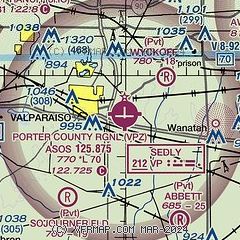
|
| Airport distance calculator |
|---|
|
|
| Sunrise and sunset |
|---|
|
Times for 18-Apr-2026
| | Local
(UTC-5) | | Zulu
(UTC) |
|---|
| Morning civil twilight | | 05:36 | | 10:36 |
| Sunrise | | 06:05 | | 11:05 |
| Sunset | | 19:30 | | 00:30 |
| Evening civil twilight | | 19:59 | | 00:59 |
|
| Current date and time |
|---|
| Zulu (UTC) | 18-Apr-2026 18:01:59 |
|---|
| Local (UTC-5) | 18-Apr-2026 13:01:59 |
|---|
|
| METAR |
|---|
| KVPZ | 181756Z AUTO 29017G22KT 10SM FEW031 BKN080 10/02 A2989 RMK AO2 SLP123 T01000017 10111 20078 51019 TSNO
|
KPPO
14nm NE | 181755Z AUTO 28010KT 10SM BKN025 BKN070 OVC090 09/06 A2987 RMK AO2 10137 20079
|
KOXI
17nm SE | 181755Z AUTO 27016G21KT 10SM OVC070 08/04 A2989 RMK AO2 10137 20078
|
KMGC
17nm NE | 181755Z AUTO 28013G18KT 10SM OVC075 08/01 A2989 RMK AO2
|
|
| TAF |
|---|
KGYY
21nm NW | 181720Z 1818/1918 29017G28KT P6SM SCT025 BKN035 FM190100 25008KT P6SM FEW035 FM191500 28012G22KT P6SM FEW040 SCT100
|
|
| NOTAMs |
|---|
NOTAMs are issued by the DoD/FAA and will open in a separate window not controlled by AirNav.
|
|

