FAA INFORMATION EFFECTIVE 16 APRIL 2026
Location
| FAA Identifier: | W20 |
| Lat/Long: | 47-08-31.2150N 119-14-16.3750W
47-08.520250N 119-14.272917W
47.1420042,-119.2378819
(estimated) |
| Elevation: | 1203 ft. / 367 m (estimated) |
| Variation: | 19E (1985) |
| From city: | 2 miles NE of MOSES LAKE, WA |
| Time zone: | UTC -7 (UTC -8 during Standard Time) |
| Zip code: | 98837 |
Airport Operations
| Airport use: | Open to the public |
| Activation date: | 03/1958 |
| Control tower: | no |
| ARTCC: | SEATTLE CENTER |
| FSS: | SEATTLE FLIGHT SERVICE STATION |
| NOTAMs facility: | SEA (NOTAM-D service available) |
| Attendance: | UNATNDD |
| Wind indicator: | lighted |
| Segmented circle: | yes |
| Lights: | SS-SR |
| Beacon: | white-green (lighted land airport)
Operates sunset to sunrise. |
Airport Communications
| CTAF/UNICOM: | 123.0 |
| WX ASOS at MWH (5 nm NW): | 119.05 (509-762-5082) |
| WX ASOS at EPH (15 nm NW): | 135.775 (509-754-3761) |
Nearby radio navigation aids
| VOR radial/distance | | VOR name | | Freq | | Var |
|---|
| MWHr124/5.2 | | MOSES LAKE VOR/DME | | 115.00 | | 18E |
| EPHr131/16.1 | | EPHRATA VORTAC | | 112.60 | | 21E |
| NDB name | | Hdg/Dist | | Freq | | Var | | ID |
|---|
| PELLY | | 025/2.2 | | 408 | | 18E | | MW | -- .-- |
Airport Services
| Parking: | tiedowns |
| Airframe service: | MAJOR |
| Powerplant service: | MAJOR |
| Bottled oxygen: | NONE |
| Bulk oxygen: | NONE |
Runway Information
Runway 16/34
| Dimensions: | 2513 x 50 ft. / 766 x 15 m |
| Surface: | asphalt, in good condition |
| Weight bearing capacity: | |
| Runway edge lights: | medium intensity |
| RUNWAY 16 | | RUNWAY 34 |
| Latitude: | 47-08.726933N | | 47-08.313567N |
| Longitude: | 119-14.270633W | | 119-14.275183W |
| Elevation: | 1200.0 ft. | | 1203.0 ft. |
| Traffic pattern: | left | | right |
| Displaced threshold: | 466 ft. | | 253 ft. |
| Markings: | basic, in good condition | | basic, in good condition |
| Visual slope indicator: | 2-light PAPI on left (3.00 degrees glide path) | | 2-light PAPI on left (3.00 degrees glide path) |
| Obstructions: | 83 ft. tree, 1648 ft. from runway, 119 ft. right of centerline, 17:1 slope to clear
15 FT FM THR 4 FT FENCE, 25 FT FM THR ROAD; 80 FT FM THR 4 FT FENCE; 45 FT TREE, 125 FT R, 153 FT FR THLD; 23 FT TREE, 83 FT R, 176 FT FM THR. | | 22 ft. bldg, 405 ft. from runway, 9:1 slope to clear
+5 FT EMBANKMENT, ROAD, CANAL, +4 FT FENCE 30 FT FM RWY END 200 FT L/R. |
Airport Ownership and Management from official FAA records
| Ownership: | Publicly-owned |
| Owner: | CITY OF MOSES LAKE
CITY HALL, P.O. BOX 1579
MOSES LAKE, WA 98837
Phone (509) 764-3701 |
| Manager: | CITY MANAGER
CITY HALL, P.O. BOX 1579
MOSES LAKE, WA 98837
Phone 509-764-3713 |
Additional Remarks
| - | BIRD HAZARD. |
| - | FOR CD CTC GRANT COUNTY APCH AT 509-762-2842, WHEN APCH CLSD CTC SEATTLE ARTCC AT 253-351-3694. |
Instrument Procedures
There are no published instrument procedures at W20.
Some nearby airports with instrument procedures:
KMWH - Grant County International Airport (5 nm NW)
KEPH - Ephrata Municipal Airport (15 nm NW)
2S8 - Wilbur Airport (42 nm NE)
KEAT - Pangborn Memorial Airport (42 nm W)
3W7 - Grand Coulee Dam Airport (47 nm N)
|
|

Road maps at:
MapQuest
Bing
Google
| Aerial photo |
|---|
WARNING: Photo may not be current or correct
 Taken in September 2007
Do you have a better or more recent aerial photo of Moses Lake Municipal Airport that you would like to share? If so, please send us your photo.
|
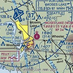
| Sectional chart |
|---|
|
| Airport distance calculator |
|---|
|
|
| Sunrise and sunset |
|---|
|
Times for 02-May-2026
| | Local
(UTC-7) | | Zulu
(UTC) |
|---|
| Morning civil twilight | | 05:06 | | 12:06 |
| Sunrise | | 05:40 | | 12:40 |
| Sunset | | 20:08 | | 03:08 |
| Evening civil twilight | | 20:42 | | 03:42 |
|
| Current date and time |
|---|
| Zulu (UTC) | 02-May-2026 20:55:34 |
|---|
| Local (UTC-7) | 02-May-2026 13:55:34 |
|---|
|
| METAR |
|---|
KMWH
5nm NW | 021952Z 34008KT 10SM CLR 28/05 A2997 RMK AO2 SLP144 T02780050
|
KEPH
15nm NW | 021953Z AUTO 04006KT 10SM CLR 26/03 A2997 RMK AO2 SLP144 T02610033 $
|
|
| TAF |
|---|
KMWH
5nm NW | 021720Z 0218/0318 05008KT P6SM FEW150 FM030000 02007KT P6SM SCT150 FM031200 36006KT P6SM SKC
|
|
| NOTAMs |
|---|
NOTAMs are issued by the DoD/FAA and will open in a separate window not controlled by AirNav.
|
|

