FAA INFORMATION EFFECTIVE 21 MARCH 2024
Location
| FAA Identifier: | WMC |
| Lat/Long: | 40-53-47.8000N 117-48-21.2000W
40-53.796667N 117-48.353333W
40.8966111,-117.8058889
(estimated) |
| Elevation: | 4307.6 ft. / 1313.0 m (surveyed) |
| Variation: | 16E (1995) |
| From city: | 5 miles SW of WINNEMUCCA, NV |
| Time zone: | UTC -7 (UTC -8 during Standard Time) |
| Zip code: | 89445 |
Airport Operations
| Airport use: | Open to the public |
| Activation date: | 10/1943 |
| Control tower: | no |
| ARTCC: | SALT LAKE CITY CENTER |
| FSS: | RENO FLIGHT SERVICE STATION |
| NOTAMs facility: | WMC (NOTAM-D service available) |
| Attendance: | NOV-MAY MON -FRI 0800-1700, JUN-OCT 0700-1800
AFT HRS OR EMERG CALL (775) 304-5885. |
| Pattern altitude: | 5107.6 ft. MSL |
| Wind indicator: | lighted |
| Segmented circle: | yes |
| Lights: | MIRL RY 14/32 PRESET LOW INTST; TO INCR INTST ACTVT - CTAF. |
| Beacon: | white-green (lighted land airport)
Operates sunset to sunrise. |
Airport Communications
| CTAF/UNICOM: | 122.8 |
| WX ASOS: | 120.175 (775-625-2200) |
- APCH/DEP CTL SVC PRVDD BY SALT LAKE CITY ARTCC (ZLC) ON FREQS 132.25/338.35 (BATTLE MOUNTAIN RCAG).
Nearby radio navigation aids
| VOR radial/distance | | VOR name | | Freq | | Var |
|---|
| SDOr143/32.3 | | SOD HOUSE VORTAC | | 111.45 | | 18E |
Airport Services
| Fuel available: | 100LL JET-A |
| Parking: | hangars and tiedowns |
| Airframe service: | MINOR |
| Powerplant service: | MINOR |
| Bottled oxygen: | HIGH/LOW |
| Bulk oxygen: | NONE |
Runway Information
Runway 14/32
| Dimensions: | 7000 x 100 ft. / 2134 x 30 m |
| Surface: | asphalt, in good condition |
| Weight bearing capacity: | | Single wheel: | 75.0 | | Double wheel: | 125.0 | | Double tandem: | 200.0 |
|
| Runway edge lights: | medium intensity |
| RUNWAY 14 | | RUNWAY 32 |
| Latitude: | 40-54.360227N | | 40-53.280047N |
| Longitude: | 117-48.836883W | | 117-48.307207W |
| Elevation: | 4301.4 ft. | | 4303.2 ft. |
| Traffic pattern: | left | | left |
| Runway heading: | 144 magnetic, 160 true | | 324 magnetic, 340 true |
| Markings: | nonprecision, in fair condition | | nonprecision, in fair condition |
| Visual slope indicator: | 2-light PAPI on left (3.00 degrees glide path) | | 2-light PAPI on left (3.00 degrees glide path) |
| Runway end identifier lights: | yes | | yes |
| Touchdown point: | yes, no lights | | yes, no lights |
| Obstructions: | 30 ft. pline, marked, 1000 ft. from runway, 26:1 slope to clear | | none |
Runway 2/20
| Dimensions: | 4800 x 75 ft. / 1463 x 23 m |
| Surface: | asphalt, in good condition |
| Weight bearing capacity: | |
| Runway edge lights: | medium intensity |
| RUNWAY 2 | | RUNWAY 20 |
| Latitude: | 40-53.458528N | | 40-54.067283N |
| Longitude: | 117-48.368165W | | 117-47.703995W |
| Elevation: | 4303.0 ft. | | 4307.4 ft. |
| Traffic pattern: | left | | left |
| Runway heading: | 024 magnetic, 040 true | | 204 magnetic, 220 true |
| Markings: | basic, in good condition | | basic, in good condition |
| Visual slope indicator: | | | 2-light PAPI on left (3.00 degrees glide path) |
| Runway end identifier lights: | no | | yes |
| Touchdown point: | yes, no lights | | yes, no lights |
| Obstructions: | none | | 12 ft. road, 500 ft. from runway, 25:1 slope to clear |
Helipad H1
| Dimensions: | 25 x 25 ft. / 8 x 8 m |
| Surface: | concrete, in excellent condition |
| Operational restrictions: | UNMRKD 25 FT X 25 FT CONCRETE TLOF ADJACENT TO APRON PRKG AND TWY ALPHA. |
| Traffic pattern: | left | | left |
| Markings: | none | | |
Helipad H2
| Dimensions: | 25 x 25 ft. / 8 x 8 m |
| Surface: | concrete, in excellent condition |
| Operational restrictions: | H2 ADJACENT TO APRON PRKG AND TAXIWAY ALPHA |
| Traffic pattern: | left | | left |
| Markings: | none | | |
Airport Ownership and Management from official FAA records
| Ownership: | Publicly-owned |
| Owner: | CITY/COUNTY OF WINNEMUCCA
90 WEST 4TH STREET
WINNEMUCCA, NV 89445
Phone 775-623-6333 |
| Manager: | ALICIA HEISER
90 WEST FOURTH STREET
WINNEMUCCA, NV 89445
Phone 775-623-6333
FBO - WINNEMUCCA AIR SERVICE 775-623-5091. |
Airport Operational Statistics
| Aircraft based on the field: | | 14 | | Single engine airplanes: | | 10 | | Ultralights: | | 4 |
| |  | |
| Aircraft operations: avg 133/week * | | 42% | transient general aviation | | 26% | local general aviation | | 26% | air taxi | | 5% | military | | * for 12-month period ending 28 September 2022 | |
Additional Remarks
| - | FULL STRENGTH PAVEMENT AREAS INCLUDE N 1000 FT OF PARALLEL TWY (RY 14/32 TO TWY A); W 1000 FT OF TWY A; 600 FT OF N/S TWR (FM TWY A). |
| - | MOUNTAINS IN SW QUADRANT. |
| - | CALL FBO FOR CURRENT RWY CONDS IN WINTER MONTHS. |
| - | FOR CD IF UNA TO CTC ON FSS FREQ, CTC SALT LAKE ARTCC AT 801-320-2568. |
Instrument Procedures
NOTE: All procedures below are presented as PDF files. If you need a reader for these files, you should download the free Adobe Reader.NOT FOR NAVIGATION. Please procure official charts for flight.
FAA instrument procedures published for use from 21 March 2024 at 0901Z to 18 April 2024 at 0900z.
IAPs - Instrument Approach Procedures |
|---|
| RNAV (GPS) RWY 14 | |
download (343KB) |
| RNAV (GPS) RWY 32 | |
download (307KB) |
| NOTE: Special Alternate Minimums apply | |
download (141KB) |
|
|---|
| FESKO ONE (OBSTACLE) (RNAV) | |
2 pages:
[1] [2] (386KB) |
| NOTE: Special Take-Off Minimums/Departure Procedures apply | |
download (380KB) |
Other nearby airports with instrument procedures:
KBAM - Battle Mountain Airport (46 nm SE)
KLOL - Derby Field Airport (61 nm SW)
KEKO - Elko Regional Airport (92 nm E)
KFLX - Fallon Municipal Airport (94 nm SW)
10U - Owyhee Airport (97 nm NE)
|
|

Road maps at:
MapQuest
Bing
Google
| Aerial photo |
|---|
WARNING: Photo may not be current or correct
 Photo taken 23-Nov-2005
Do you have a better or more recent aerial photo of Winnemucca Municipal Airport that you would like to share? If so, please send us your photo.
|
| Sectional chart |
|---|
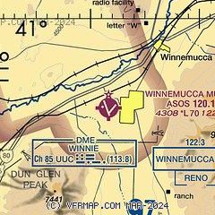
|
| Airport distance calculator |
|---|
|
|
| Sunrise and sunset |
|---|
|
Times for 18-Apr-2024
| | Local
(UTC-7) | | Zulu
(UTC) |
|---|
| Morning civil twilight | | 05:38 | | 12:38 |
| Sunrise | | 06:07 | | 13:07 |
| Sunset | | 19:34 | | 02:34 |
| Evening civil twilight | | 20:03 | | 03:03 |
|
| Current date and time |
|---|
| Zulu (UTC) | 18-Apr-2024 09:28:46 |
|---|
| Local (UTC-7) | 18-Apr-2024 02:28:46 |
|---|
|
| METAR |
|---|
| KWMC | 180856Z AUTO 05013KT 10SM CLR 02/M08 A3020 RMK AO2 SLP219 T00221083 58000 TSNO
|
|
| TAF |
|---|
| KWMC | 180520Z 1806/1906 04010G20KT P6SM SKC FM181200 05010KT P6SM SKC FM190000 33006KT P6SM BKN250
|
|
| NOTAMs |
|---|
NOTAMs are issued by the DoD/FAA and will open in a separate window not controlled by AirNav.
|
|

