FAA INFORMATION EFFECTIVE 27 NOVEMBER 2025
Location
| FAA Identifier: | WST |
| Lat/Long: | 41-20-58.6787N 071-48-12.3006W
41-20.977978N 071-48.205010W
41.3496330,-71.8034168
(estimated) |
| Elevation: | 81.1 ft. / 24.7 m (surveyed) |
| Variation: | 15W (1995) |
| From city: | 2 miles SE of WESTERLY, RI |
| Time zone: | UTC -5 (UTC -4 during Daylight Saving Time) |
| Zip code: | 02891 |
Airport Operations
| Airport use: | Open to the public |
| Activation date: | 12/1939 |
| Control tower: | no |
| ARTCC: | BOSTON CENTER |
| FSS: | BRIDGEPORT FLIGHT SERVICE STATION |
| NOTAMs facility: | WST (NOTAM-D service available) |
| Attendance: | JUN-SEP SUN-SAT 0800-1700, OCT-MAY SUN-SAT 0800-1600 |
| Wind indicator: | lighted |
| Segmented circle: | yes |
| Lights: | DUSK-DAWN. ACTVT MALSF RWY 07; REIL RWY 25, 14 & 32; PAPI RWY 7, 14 & 32, VASI RWY 25; MIRL RWY 07/25 & 14/32 - CTAF. |
| Beacon: | white-green (lighted land airport)
Operates sunset to sunrise. |
| Landing fee: | yes, LDG FEE FOR COML & NON-RHODE ISLAND REGISTERED ACFT. |
Airport Communications
| CTAF/UNICOM: | 123.0 |
| WX ASOS: | 132.375 (401-596-9543) |
| PROVIDENCE APPROACH: | 119.45 ;S OF ORW [SUN-FRI 0530-0030 SAT 0530-0000] |
| WX ASOS at GON (11 nm W): | 127.0 (860-449-8921) |
| WX AWOS-3PT at BID (15 nm SE): | 134.775 (401-466-5495) |
- APCH/DEP SVC PRVDD BY BOSTON ARTCC ON FREQS 124.85/307.9 (WOODSTOCK RCAG) WHEN PROVIDENCE APCH CTL CLSD.
Nearby radio navigation aids
| VOR radial/distance | | VOR name | | Freq | | Var |
|---|
| GONr098/11.3 | | GROTON VOR/DME | | 110.85 | | 14W |
| SEYr332/15.0 | | SANDY POINT VOR/DME | | 117.80 | | 15W |
| ORWr159/15.2 | | NORWICH VOR/DME | | 110.00 | | 14W |
| PVDr231/28.1 | | PROVIDENCE VOR/DME | | 115.60 | | 14W |
| HTOr055/34.7 | | HAMPTON VORTAC | | 113.60 | | 13W |
| PUTr191/36.4 | | PUTNAM VOR/DME | | 117.40 | | 14W |
| HFDr131/37.7 | | HARTFORD VOR/DME | | 114.90 | | 13W |
Airport Services
| Fuel available: | 100LL JET-A
A:AVBL AT DOONEY AVIATION.
100LL:SELF SVC 100LL FUEL AVBL 24 HRS. |
| Parking: | tiedowns |
| Airframe service: | MAJOR |
| Powerplant service: | MAJOR |
| Bottled oxygen: | NONE |
| Bulk oxygen: | NONE |
Runway Information
Runway 7/25
| Dimensions: | 4010 x 100 ft. / 1222 x 30 m |
| Surface: | asphalt/grooved, in fair condition |
| Weight bearing capacity: | | Single wheel: | 30.0 | | Double wheel: | 60.0 |
|
| Runway edge lights: | medium intensity |
| RUNWAY 7 | | RUNWAY 25 |
| Latitude: | 41-20.735867N | | 41-21.131250N |
| Longitude: | 071-48.635383W | | 071-47.933683W |
| Elevation: | 51.1 ft. | | 78.3 ft. |
| Traffic pattern: | left | | left |
| Runway heading: | 068 magnetic, 053 true | | 248 magnetic, 233 true |
| Markings: | basic, in fair condition | | nonprecision, in fair condition |
| Visual slope indicator: | 4-light PAPI on right (3.50 degrees glide path)
PAPI U/S. | | 2-box VASI on left (3.50 degrees glide path) |
| Approach lights: | MALSF: 1,400 foot medium intensity approach lighting system with sequenced flashers | | |
| Runway end identifier lights: | no | | yes |
| Touchdown point: | yes, no lights | | yes, no lights |
| Instrument approach: | LOC/DME | | |
| Obstructions: | 117 ft. trees, 2200 ft. from runway, 330 ft. right of centerline, 17:1 slope to clear
22:1 TO TEMPO DTHR. | | 48 ft. trees, 1100 ft. from runway, 40 ft. left of centerline, 18:1 slope to clear
+10 FT TREES, 170 FT - 200 FT FM THR, 180 FT L. |
Runway 14/32
| Dimensions: | 3960 x 75 ft. / 1207 x 23 m |
| Surface: | asphalt, in fair condition |
| Weight bearing capacity: | |
| Runway edge lights: | medium intensity |
| RUNWAY 14 | | RUNWAY 32 |
| Latitude: | 41-21.232917N | | 41-20.813000N |
| Longitude: | 071-48.455467W | | 071-47.793500W |
| Elevation: | 56.9 ft. | | 81.1 ft. |
| Traffic pattern: | left | | left |
| Runway heading: | 145 magnetic, 130 true | | 325 magnetic, 310 true |
| Displaced threshold: | no
TEMPO DTHR 595 FT. | | 750 ft. |
| Markings: | basic, in fair condition | | basic, in fair condition |
| Visual slope indicator: | 4-light PAPI on left (4.00 degrees glide path)
PAPI U/S. | | 4-light PAPI on left (4.00 degrees glide path) |
| Runway end identifier lights: | yes | | yes |
| Touchdown point: | yes, no lights | | yes, no lights |
| Obstructions: | 17 ft. trees, 380 ft. from runway, 140 ft. left of centerline, 10:1 slope to clear
+10 FT TREES, 100 FT FM THR, 110 FT L; +10 FT TREES, 100 FT FM THR, 120 FT R. | | 33 ft. trees, 425 ft. from runway, 100 ft. left of centerline, 6:1 slope to clear
+20 FT TREES, 200 FT FM THR, 125 FT L. |
Airport Ownership and Management from official FAA records
| Ownership: | Publicly-owned |
| Owner: | RHODE ISLAND AIRPORT CORPORATION
2000 POST RD
WARWICK, RI 02886
Phone 401-691-2265 |
| Manager: | IFTIKHAR AHMAD
RHODE ISLAND AIRPORT CORP, 2000 POST RD
WARWICK, RI 02886
Phone 401-691-2265 |
Additional Remarks
| - | RWY 07/25 UNEVEN PAVEMENT APRXLY 1000 FT FM AER 25 THR. CTC AMGR 401-691-2265. |
| - | FOR CD CTC PROVIDENCE APCH AT 401-738-8945, WHEN APCH CLSD CTC BOSTON ARTCC AT 603-879-6859. |
| - | GLDRS OPR FM ARPT ON INTMNT BASIS. |
| - | DEER & BIRDS ON & INVOF ARPT. |
| - | RWY CONDS MAY NOT BE MNT OR RPRTD WHEN AP IS UNATNDD. CTC RI AP CORPORATION OPS AT 401-691-2265. |
| - | OVNGT PRKG FEE. |
| - | ARPT LCTD IN NOISE SENSITIVE AREA. POPULATED AREAS TO THE S & W SHOULD BE AVOIDED. |
| - | HEL TOURS & BANNER TOW OPS ON AIRFIELD BLW 1000 FT ALG SOUTHERN COAST OF RHODE ISLAND. |
| - | NOISE ABATEMENT PROCS IN EFCT CTC AMGR AT 401-691-2265. |
| - | RWY 07/25 IS PREFERRED CALM WIND RWY. |
| - | FOR AFT HRS TRML APRON ACES CTC AMGR 401-691-2265. |
| A51-07 | TEMPO DTHR 375 FT. |
Instrument Procedures
NOTE: All procedures below are presented as PDF files. If you need a reader for these files, you should download the free Adobe Reader.NOT FOR NAVIGATION. Please procure official charts for flight.
FAA instrument procedures published for use from 27 November 2025 at 0901Z to 25 December 2025 at 0900Z.
STARs - Standard Terminal Arrivals |
|---|
| SARDI ONE (RNAV) | |
2 pages:
[1] [2] (474KB) |
IAPs - Instrument Approach Procedures |
|---|
| RNAV (GPS) RWY 07 | |
download (270KB) |
| LOC RWY 07 | |
download (243KB) |
| NOTE: Special Take-Off Minimums/Departure Procedures apply | |
download (178KB) |
Other nearby airports with instrument procedures:
KGON - Groton-New London Airport (11 nm W)
0B8 - Elizabeth Field Airport (12 nm SW)
KBID - Block Island State Airport (15 nm SE)
KMTP - Montauk Airport (17 nm S)
KOQU - Quonset State Airport (23 nm NE)
|
|

Road maps at:
MapQuest
Bing
Google
| Aerial photo |
|---|
WARNING: Photo may not be current or correct
 Photo courtesy of AirNav, LLC
Photo taken 24-Aug-2012
looking southwest.
Photo courtesy of AirNav, LLC
Photo taken 24-Aug-2012
looking southwest.
Do you have a better or more recent aerial photo of Westerly State Airport that you would like to share? If so, please send us your photo.
|
| Sectional chart |
|---|
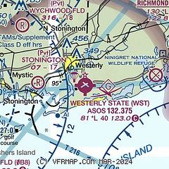
|
CAUTION: Diagram may not be current

| Airport distance calculator |
|---|
|
|
| Sunrise and sunset |
|---|
|
Times for 12-Dec-2025
| | Local
(UTC-5) | | Zulu
(UTC) |
|---|
| Morning civil twilight | | 06:34 | | 11:34 |
| Sunrise | | 07:05 | | 12:05 |
| Sunset | | 16:17 | | 21:17 |
| Evening civil twilight | | 16:48 | | 21:48 |
|
| Current date and time |
|---|
| Zulu (UTC) | 12-Dec-2025 22:08:09 |
|---|
| Local (UTC-5) | 12-Dec-2025 17:08:09 |
|---|
|
| METAR |
|---|
| KWST | 122153Z AUTO 27004KT 10SM CLR 00/M11 A2998 RMK AO2 SLP152 T00001106
|
KGON
11nm W | 122156Z 26008KT 10SM CLR 00/M11 A2999 RMK AO2 SLP155 T00001106
|
KBID
15nm SE | 122156Z AUTO 28012G20KT 10SM CLR 01/M09 A2998 RMK AO2 SLP153 T00061094 FZRANO $
|
KMTP
18nm S | 122154Z AUTO 28011G20KT 02/M08 A3001 RMK AO1 SLP161 T00171083
|
|
| TAF |
|---|
KGON
11nm W | 121731Z 1218/1318 29015G23KT P6SM SKC FM122200 28011G18KT P6SM SKC FM130000 27008KT P6SM SKC FM131300 22010KT P6SM SCT040 BKN100
|
|
| NOTAMs |
|---|
NOTAMs are issued by the DoD/FAA and will open in a separate window not controlled by AirNav.
|
|


