FAA INFORMATION EFFECTIVE 19 MARCH 2026
Location
| FAA Identifier: | Y88 |
| Lat/Long: | 44-36-20.5349N 085-45-24.4444W
44-36.342248N 085-45.407407W
44.6057041,-85.7567901
(estimated) |
| Elevation: | 866 ft. / 264 m (estimated) |
| From city: | 3 miles S of INTERLOCHEN, MI |
| Time zone: | UTC -4 (UTC -5 during Standard Time) |
| Zip code: | 49643 |
Airport Operations
| Airport use: | Open to the public |
| Activation date: | 06/1949 |
| Control tower: | no |
| ARTCC: | MINNEAPOLIS CENTER |
| FSS: | LANSING FLIGHT SERVICE STATION |
| NOTAMs facility: | LAN (NOTAM-D service available) |
| Attendance: | UNATNDD |
| Wind indicator: | yes |
| Segmented circle: | yes |
Airport Communications
| CTAF: | 122.9 |
| WX ASOS at TVC (11 nm NE): | PHONE 231-486-2920 |
| WX AWOS-3P at FKS (19 nm W): | 118.325 (231-352-7573) |
Nearby radio navigation aids
| VOR radial/distance | | VOR name | | Freq | | Var |
|---|
| TVCr249/9.6 | | TRAVERSE CITY VOR/DME | | 114.60 | | 02W |
Airport Services
| Parking: | tiedowns |
| Airframe service: | NONE |
| Powerplant service: | NONE |
| Bottled oxygen: | NONE |
| Bulk oxygen: | NONE |
Runway Information
Runway 5/23
| Dimensions: | 2800 x 170 ft. / 853 x 52 m |
| Surface: | turf, in fair condition |
| Runway edge markings: | RWY & DTHR MKD WITH 3 FT YELLOW CONES. |
| RUNWAY 5 | | RUNWAY 23 |
| Latitude: | 44-36.221667N | | 44-36.520000N |
| Longitude: | 085-45.708333W | | 085-45.216667W |
| Elevation: | 866.0 ft. | | 866.0 ft. |
| Traffic pattern: | left | | left |
| Runway heading: | 050 true | | 230 true |
| Displaced threshold: | 409 ft. | | 1180 ft. |
| Obstructions: | 63 ft. trees, 50 ft. from runway, 130 ft. left of centerline, 1:1 slope to clear
APCH SLP 7:1 TO DTHR DUE TO 63 FT TREE, 450 FT DIST, 130 FT L. | | 65 ft. trees, 120 ft. from runway, 140 ft. right of centerline, 1:1 slope to clear
APCH SLP 13:1 TO DTHR DUE TO 65 FT TREE, 900 FT DIST, 140 FT R. |
Runway 16/34
| Dimensions: | 1700 x 170 ft. / 518 x 52 m |
| Surface: | turf, in fair condition |
| Runway edge markings: | RWY & DTHR MKD WITH 3 FT YELLOW CONES. |
| Operational restrictions: | CLSD WHEN ATHLETIC FLDS IN USE ON NORTH END EXTDD CNTRLN. |
| RUNWAY 16 | | RUNWAY 34 |
| Latitude: | 44-36.428667N | | 44-36.161667N |
| Longitude: | 085-45.375000W | | 085-45.258333W |
| Elevation: | 866.0 ft. | | 866.0 ft. |
| Traffic pattern: | left | | left |
| Runway heading: | 163 true | | 343 true |
| Displaced threshold: | 176 ft. | | 402 ft. |
| Obstructions: | 70 ft. trees, 950 ft. from runway, 80 ft. left of centerline, 13:1 slope to clear
APCH SLP 16:1 TO DTHR DUE TO 70 FT TREE, 1126 FT DIST, 80 FT L. | | 70 ft. trees, 750 ft. from runway, 85 ft. both sides of centerline, 10:1 slope to clear
APCH SLP 16:1 TO DTHR DUE TO 70 FT TREE, 1152 FT DIST, 85 FT L/R. |
Airport Ownership and Management from official FAA records
| Ownership: | Publicly-owned |
| Owner: | GREEN LAKE TOWNSHIP
9394 10TH ST
INTERLOCHEN, MI 49643-9389
Phone 231-276-9329
EXTN 113. |
| Manager: | JIM ANDERSON
12012 S ELK RUN
TRAVERSE CITY, MI 49684-7703
Phone 231-409-7149
CELL. |
Additional Remarks
| - | NOISE SENSITIVE AREA 1 NM NORTH OF ARPT. |
| - | 460 FT ANT 2 NM NORTH OF ARPT. |
| - | UAS OPRG AREA SOUTH OF RWY 34 DEFINED BY MOWED X SHAPE. |
| - | ADMIN BLDG ACES: PRESS V, THEN III & II SIMUL, THEN I. |
| - | NO SNOW REMOVAL. |
| - | FOR CD CTC MINNEAPOLIS ARTCC AT 651-463-5588. |
Instrument Procedures
There are no published instrument procedures at Y88.
Some nearby airports with instrument procedures:
KTVC - Cherry Capital Airport (11 nm NE)
KFKS - Frankfort Dow Memorial Field (19 nm W)
KCAD - Wexford County Airport (25 nm SE)
KMBL - Manistee County/Blacker Airport (29 nm SW)
KACB - Antrim County Airport (33 nm NE)
|
|

Road maps at:
MapQuest
Bing
Google
| Aerial photo |
|---|
WARNING: Photo may not be current or correct
 Photo by Chad Thomas - JetwashImages.com
Photo taken 04-Jul-2006
Photo by Chad Thomas - JetwashImages.com
Photo taken 04-Jul-2006
Do you have a better or more recent aerial photo of Green Lake Airport that you would like to share? If so, please send us your photo.
|
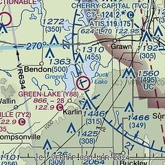
| Sectional chart |
|---|
|
| Airport distance calculator |
|---|
|
|
| Sunrise and sunset |
|---|
|
Times for 14-Apr-2026
| | Local
(UTC-4) | | Zulu
(UTC) |
|---|
| Morning civil twilight | | 06:31 | | 10:31 |
| Sunrise | | 07:02 | | 11:02 |
| Sunset | | 20:25 | | 00:25 |
| Evening civil twilight | | 20:55 | | 00:55 |
|
| Current date and time |
|---|
| Zulu (UTC) | 14-Apr-2026 18:02:48 |
|---|
| Local (UTC-4) | 14-Apr-2026 14:02:48 |
|---|
|
| METAR |
|---|
KTVC
11nm NE | 141753Z 25005KT 10SM OVC020 18/13 A2980 RMK AO2 SLP090 T01780128 10178 20078 58002
|
KFKS
19nm W | 141755Z AUTO 26008KT 10SM CLR 18/13 A2981 RMK AO2 10188 20099
|
|
| TAF |
|---|
KTVC
11nm NE | 141725Z 1418/1518 VRB03KT P6SM OVC015 FM142000 04005KT P6SM BKN025 FM150000 VRB03KT P6SM VCTS SCT008CB BKN010 PROB30 1503/1506 4SM -TSRA BKN008CB FM150600 VRB03KT 2SM BR VCSH OVC004 FM151200 35003KT 1SM BR OVC003
|
|
| NOTAMs |
|---|
NOTAMs are issued by the DoD/FAA and will open in a separate window not controlled by AirNav.
|
|

