FAA INFORMATION EFFECTIVE 09 JULY 2026
Location
| FAA Identifier: | ACB |
| Lat/Long: | 44-59-18.8790N 085-11-54.0480W
44-59.314650N 085-11.900800W
44.9885775,-85.1983467
(estimated) |
| Elevation: | 623 ft. / 189.9 m (surveyed) |
| Variation: | 05W (1990) |
| From city: | 1 mile NE of BELLAIRE, MI |
| Time zone: | UTC -4 (UTC -5 during Standard Time) |
| Zip code: | 49615 |
Airport Operations
| Airport use: | Open to the public |
| Activation date: | 07/1944 |
| Control tower: | no |
| ARTCC: | MINNEAPOLIS CENTER |
| FSS: | LANSING FLIGHT SERVICE STATION |
| NOTAMs facility: | ACB (NOTAM-D service available) |
| Attendance: | 0700-1700
UNATNDD MAJOR HOLS. |
| Wind indicator: | lighted, LGTD SUPPLL WIND CONES EACH END RWY 02 & 20. |
| Segmented circle: | yes |
| Lights: | ACTVT OR INCR INTST REIL RWY 02 & 20; PAPI RWY 02 & 20; MIRL RWY 02/20 - CTAF. MIRL RWY 02/20 PRESET LOW INTST. |
| Beacon: | white-green (lighted land airport)
Operates sunset to sunrise. |
| Landing fee: | yes, LDG FEE APPLIES TO TURBINE & JET ENG ACFT; WAIVED WITH MNM FUEL PURCHASE. |
Airport Communications
| CTAF/UNICOM: | 122.7 |
| WX AWOS-3P: | 119.275 (231-533-8941) |
| WX AWOS-3PT at BFA (16 nm NE): | 118.675 (231-330-8677) |
| WX AWOS-3P at CVX (19 nm N): | 120.0 (231-237-9703) |
- APCH/DEP SVC PRVDD BY MINNEAPOLIS ARTCC ON 132.9/338.3 (TRAVERSE CITY RCAG).
Nearby radio navigation aids
| VOR radial/distance | | VOR name | | Freq | | Var |
|---|
| TVCr040/24.4 | | TRAVERSE CITY VOR/DME | | 114.60 | | 02W |
| CGGr319/(27.2) | | GRAYLING VOR | | 109.80 | | 06W |
| NDB name | | Hdg/Dist | | Freq | | Var | | ID |
|---|
| GRAYLING | | 318/21.3 | | 359 | | 06W | | GYG | --. -.-- --. |
Airport Services
| Fuel available: | 100LL JET-A+
100LL:FOR FUEL AFT HRS CALL 231-350-8145. |
| Parking: | hangars and tiedowns |
Runway Information
Runway 2/20
| Dimensions: | 5003 x 100 ft. / 1525 x 30 m |
| Surface: | asphalt/porous friction courses, in good condition |
| Weight bearing capacity: | | Single wheel: | 38.0 | | Double wheel: | 55.0 |
|
| Runway edge lights: | medium intensity |
| RUNWAY 2 | | RUNWAY 20 |
| Latitude: | 44-58.921930N | | 44-59.707360N |
| Longitude: | 085-12.074477W | | 085-11.727070W |
| Elevation: | 621.6 ft. | | 617.5 ft. |
| Traffic pattern: | left | | left |
| Runway heading: | 022 magnetic, 017 true | | 202 magnetic, 197 true |
| Markings: | nonprecision, in good condition | | nonprecision, in good condition |
| Visual slope indicator: | 4-light PAPI on left (3.00 degrees glide path) | | 2-light PAPI on left (3.25 degrees glide path) |
| Runway end identifier lights: | yes | | yes |
| Touchdown point: | yes, no lights | | yes, no lights |
| Obstructions: | 62 ft. tree, 1667 ft. from runway, 112 ft. right of centerline, 23:1 slope to clear | | none |
Airport Ownership and Management from official FAA records
| Ownership: | Publicly-owned |
| Owner: | ANTRIM COUNTY
PO BOX 520, 230 E CAYUGA ST
BELLAIRE, MI 49615-0520
Phone 231-533-6353 |
| Manager: | MATTHEW WYMAN
3366A S DERENZY RD
BELLAIRE, MI 49615-9499
Phone 231-533-8524
CELL 231-622-1926. |
Additional Remarks
| - | LRG BIRDS ON & INVOF ARPT. |
| - | SNOW REMOVAL EQPT ON RWY & TWYS DURG WINTER MONTHS. |
| - | FOR CD CTC MINNEAPOLIS ARTCC AT 651-463-5588. |
Instrument Procedures
NOTE: All procedures below are presented as PDF files. If you need a reader for these files, you should download the free Adobe Reader.NOT FOR NAVIGATION. Please procure official charts for flight.
FAA instrument procedures published for use from 09 July 2026 at 0901Z to 06 August 2026 at 0900Z.
IAPs - Instrument Approach Procedures |
|---|
| RNAV (GPS) RWY 02 | |
download (286KB) |
| NOTE: Special Alternate Minimums apply | |
download (136KB) |
| NOTE: Special Take-Off Minimums/Departure Procedures apply | |
download (122KB) |
Other nearby airports with instrument procedures:
KBFA - Boyne Mountain Airport (16 nm NE)
N98 - Boyne City Municipal Airport (16 nm NE)
KCVX - Charlevoix Municipal Airport (19 nm N)
KGLR - Gaylord Regional Airport (21 nm E)
KTVC - Cherry Capital Airport (22 nm SW)
|
|

Road maps at:
MapQuest
Bing
Google
| Aerial photo |
|---|
WARNING: Photo may not be current or correct
 Photo by Terry Graham
Photo taken 12-Aug-2020
looking north.
Photo by Terry Graham
Photo taken 12-Aug-2020
looking north.
Do you have a better or more recent aerial photo of Antrim County Airport that you would like to share? If so, please send us your photo.
|
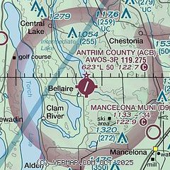
| Sectional chart |
|---|
|
| Airport distance calculator |
|---|
|
|
| Sunrise and sunset |
|---|
|
Times for 27-Jul-2026
| | Local
(UTC-4) | | Zulu
(UTC) |
|---|
| Morning civil twilight | | 05:47 | | 09:47 |
| Sunrise | | 06:22 | | 10:22 |
| Sunset | | 21:13 | | 01:13 |
| Evening civil twilight | | 21:47 | | 01:47 |
|
| Current date and time |
|---|
| Zulu (UTC) | 28-Jul-2026 03:28:22 |
|---|
| Local (UTC-4) | 27-Jul-2026 23:28:22 |
|---|
|
| METAR |
|---|
| KACB | 280315Z AUTO 01004KT 10SM SCT006 SCT009 19/18 A2971 RMK AO2 T01900180
|
KBFA
16nm NE | 280315Z AUTO 01007KT 10SM FEW009 FEW015 20/20 A2971 RMK AO2 LTG DSNT ALQDS
|
KCVX
19nm N | 280315Z AUTO 33006KT 9SM CLR 20/18 A2971 RMK AO2
|
|
| TAF |
|---|
KTVC
22nm SW | 280125Z 2801/2824 26004KT P6SM -SHRA BKN040 TEMPO 2801/2803 3SM -TSRA BR OVC025CB FM280400 35011G22KT P6SM BKN016 FM280900 36011G23KT P6SM BKN020 FM281100 36012G24KT P6SM BKN090
|
|
| NOTAMs |
|---|
NOTAMs are issued by the DoD/FAA and will open in a separate window not controlled by AirNav.
|
|

