FAA INFORMATION EFFECTIVE 19 MARCH 2026
Location
| FAA Identifier: | ZZV |
| Lat/Long: | 39-56-40.0060N 081-53-31.5390W
39-56.666767N 081-53.525650W
39.9444461,-81.8920942
(estimated) |
| Elevation: | 899.8 ft. / 274.3 m (surveyed) |
| Variation: | 06W (1990) |
| From city: | 5 miles E of ZANESVILLE, OH |
| Time zone: | UTC -4 (UTC -5 during Standard Time) |
| Zip code: | 43701 |
Airport Operations
| Airport use: | Open to the public |
| Activation date: | 11/1944 |
| Control tower: | no |
| ARTCC: | INDIANAPOLIS CENTER |
| FSS: | CLEVELAND FLIGHT SERVICE STATION |
| NOTAMs facility: | ZZV (NOTAM-D service available) |
| Attendance: | MON-FRI 0800-1800, ALL SAT-SUN 1000-1800 |
| Wind indicator: | lighted |
| Segmented circle: | no |
| Lights: | ACTVT REIL RWY 04, 22, 16, & 34; HIRL RWY 04/22; MIRL RWY 16/34 - CTAF. PAPI RWY 04 & 22 OPR CONSLY. |
| Beacon: | white-green (lighted land airport)
Operates sunset to sunrise. |
Airport Communications
| CTAF/UNICOM: | 123.0 |
| WX ASOS: | 127.0 (740-453-8139) |
| WX AWOS-3 at CDI (15 nm E): | 118.525 (740-435-0086) |
- APCH/DEP SVC PRVDD BY INDIANAPOLIS ARTCC ON FREQS 124.45/323.275 (ZANESVILLE RCAG).
Nearby radio navigation aids
| VOR radial/distance | | VOR name | | Freq | | Var |
|---|
| APEr117/34.3 | | APPLETON VORTAC | | 116.70 | | 06W |
| JPUr325/38.5 | | PARKERSBURG VOR/DME | | 114.45 | | 03W |
Airport Services
| Fuel available: | 100LL JET-A
A:ANTI-ICING AVBL AT NOZZLE. |
| Parking: | hangars and tiedowns |
| Airframe service: | NONE |
| Powerplant service: | NONE |
| Bottled oxygen: | NONE |
| Bulk oxygen: | LOW |
Runway Information
Runway 4/22
| Dimensions: | 4999 x 150 ft. / 1524 x 46 m |
| Surface: | asphalt, in good condition |
| Weight bearing capacity: | | Single wheel: | 38.0 | | Double wheel: | 50.0 | | Double tandem: | 75.0 |
|
| Runway edge lights: | high intensity |
| Runway edge markings: | FADED. |
| RUNWAY 4 | | RUNWAY 22 |
| Latitude: | 39-56.343078N | | 39-57.027038N |
| Longitude: | 081-53.751047W | | 081-53.155440W |
| Elevation: | 896.1 ft. | | 869.4 ft. |
| Traffic pattern: | left | | left |
| Runway heading: | 040 magnetic, 034 true | | 220 magnetic, 214 true |
| Markings: | nonprecision, in poor condition | | precision, in poor condition |
| Visual slope indicator: | 4-light PAPI on right (3.00 degrees glide path)
PAPI UNUSBL BYD 4 DEGS RIGHT OF CNTRLN, BAFFLED DUE TO OBSTS. | | 4-light PAPI on left (3.00 degrees glide path) |
| Runway end identifier lights: | yes | | yes |
| Touchdown point: | yes, no lights | | yes, no lights |
| Instrument approach: | | | ILS/DME |
| Obstructions: | 55 ft. trees, 785 ft. from runway, 330 ft. left of centerline, 10:1 slope to clear
RWY 04 +5 FT BRUSH 100-200 FT FM 160-275 FT R. | | none |
Runway 16/34
| Dimensions: | 4998 x 75 ft. / 1523 x 23 m |
| Surface: | asphalt/aggregate friction seal coat, in good condition |
| Weight bearing capacity: | | Single wheel: | 38.0 | | Double wheel: | 50.0 | | Double tandem: | 75.0 |
|
| Runway edge lights: | medium intensity |
| RUNWAY 16 | | RUNWAY 34 |
| Latitude: | 39-57.013473N | | 39-56.283442N |
| Longitude: | 081-53.845182W | | 081-53.350952W |
| Elevation: | 866.7 ft. | | 895.4 ft. |
| Traffic pattern: | left | | left |
| Runway heading: | 158 magnetic, 152 true | | 338 magnetic, 332 true |
| Displaced threshold: | 200 ft. | | 200 ft. |
| Declared distances: | TORA:4998 TODA:4998 ASDA:4798 LDA:4598 | | TORA:4998 TODA:4998 ASDA:4798 LDA:4598 |
| Markings: | nonprecision, in good condition | | nonprecision, in good condition |
| Visual slope indicator: | | | 4-light PAPI on left |
| Runway end identifier lights: | yes | | yes |
| Touchdown point: | yes, no lights | | yes, no lights |
| Obstructions: | 35 ft. trees, marked and lighted, 850 ft. from runway, 115 ft. left of centerline, 18:1 slope to clear
RWY 16 +2-5 FT BRUSH 125 FT FM 130 FT L/R. | | 5 ft. brush, 215 ft. from runway, 55 ft. right of centerline, 3:1 slope to clear
20:1 APCH SLP CLR TO DTHR. |
Airport Ownership and Management from official FAA records
| Ownership: | Publicly-owned |
| Owner: | CITY OF ZANESVILLE
401 MARKET ST
ZANESVILLE, OH 43701-3520
Phone 740-455-0663 |
| Manager: | JIM WITTE
850 AIRPORT RD
ZANESVILLE, OH 43701-0969
Phone 740-452-3625 |
Additional Remarks
| - | DEER, BIRDS, & OTR WILDLIFE ON & INVOF ARPT. |
| - | RWY 04/22 & RWY 16/34 ACFT NOT VSB FM RWY ENDS. |
| - | TWY B LGTS U/S INDEFLY. |
| - | FOR CD IF UNA TO CTC ON FSS FREQ, CTC INDIANAPOLIS ARTCC AT 317-247-2411. |
Instrument Procedures
NOTE: All procedures below are presented as PDF files. If you need a reader for these files, you should download the free Adobe Reader.NOT FOR NAVIGATION. Please procure official charts for flight.
FAA instrument procedures published for use from 19 March 2026 at 0901Z to 16 April 2026 at 0900Z.
IAPs - Instrument Approach Procedures |
|---|
| ILS OR LOC RWY 22 | |
download (221KB) |
| RNAV (GPS) RWY 04 | |
download (199KB) |
| RNAV (GPS) RWY 22 | |
download (208KB) |
| NOTE: Special Alternate Minimums apply | |
download (168KB) |
| NOTE: Special Take-Off Minimums/Departure Procedures apply | |
download (467KB) |
Other nearby airports with instrument procedures:
KCDI - Cambridge Municipal Airport (15 nm E)
I10 - Noble County Airport (19 nm SE)
I86 - Ed Newlon Field Airport (21 nm SW)
I40 - Richard Downing Airport (22 nm N)
KVTA - Licking County Regional Airport (27 nm W)
|
|

Road maps at:
MapQuest
Bing
Google
| Aerial photo |
|---|
WARNING: Photo may not be current or correct
 Photo courtesy of AirNav, LLC
Photo taken 09-May-2010
Photo courtesy of AirNav, LLC
Photo taken 09-May-2010
Do you have a better or more recent aerial photo of Zanesville Municipal Airport that you would like to share? If so, please send us your photo.
|
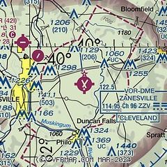
| Sectional chart |
|---|
|
| Airport distance calculator |
|---|
|
|
| Sunrise and sunset |
|---|
|
Times for 13-Apr-2026
| | Local
(UTC-4) | | Zulu
(UTC) |
|---|
| Morning civil twilight | | 06:26 | | 10:26 |
| Sunrise | | 06:54 | | 10:54 |
| Sunset | | 20:03 | | 00:03 |
| Evening civil twilight | | 20:30 | | 00:30 |
|
| Current date and time |
|---|
| Zulu (UTC) | 14-Apr-2026 02:43:02 |
|---|
| Local (UTC-4) | 13-Apr-2026 22:43:02 |
|---|
|
| METAR |
|---|
| KZZV | 140153Z AUTO 20007KT 10SM CLR 21/13 A3008 RMK AO2 SLP179 T02060133
|
KCDI
15nm E | 140215Z AUTO 20004KT 10SM CLR 19/15 A3009 RMK AO2 T01920147
|
|
| TAF |
|---|
| KZZV | 131728Z 1318/1418 24010G20KT P6SM SCT060 FM140000 22008KT P6SM BKN060 FM141400 22012G25KT P6SM SCT025 BKN040 PROB30 1414/1418 5SM -TSRA BKN035CB
|
|
| NOTAMs |
|---|
NOTAMs are issued by the DoD/FAA and will open in a separate window not controlled by AirNav.
|
|


