FAA INFORMATION EFFECTIVE 14 MAY 2026
Location
| FAA Identifier: | C59 |
| Lat/Long: | 42-38-02.8540N 088-36-04.0650W
42-38.047567N 088-36.067750W
42.6341261,-88.6011292
(estimated) |
| Elevation: | 981 ft. / 299 m (estimated) |
| Variation: | 02W (2005) |
| From city: | 2 miles E of DELAVAN, WI |
| Time zone: | UTC -5 (UTC -6 during Standard Time) |
| Zip code: | 53115 |
Airport Operations
| Airport use: | Open to the public |
| Activation date: | 04/1974 |
| Control tower: | no |
| ARTCC: | CHICAGO CENTER |
| FSS: | GREEN BAY FLIGHT SERVICE STATION |
| NOTAMs facility: | GRB (NOTAM-D service available) |
| Attendance: | UNATNDD |
| Wind indicator: | yes |
| Segmented circle: | no |
Airport Communications
| CTAF: | 122.9 |
| ROCKFORD APPROACH: | 121.0 [0800-1600 MON-FRI; EXCP HOLS] |
| ROCKFORD DEPARTURE: | 121.0 [0800-1600 MON-FRI; EXCP HOLS] |
| WX AWOS-3 at BUU (14 nm E): | 125.275 (262-757-0907) |
| WX AWOS-3PT at 57C (14 nm NE): | 118.125 (262-642-1845) |
| WX AWOS-3 at JVL (19 nm W): | PHONE 608-758-1723 |
Nearby radio navigation aids
| VOR radial/distance | | VOR name | | Freq | | Var |
|---|
| JVLr075/22.7 | | JANESVILLE VOR/DME | | 114.30 | | 03E |
| BAEr204/32.1 | | BADGER VOR/DME | | 116.40 | | 02E |
| OBKr313/38.0 | | NORTHBROOK VOR/DME | | 113.00 | | 02W |
| NDB name | | Hdg/Dist | | Freq | | Var | | ID |
|---|
| ROCK RIVER | | 171/32.8 | | 371 | | 01W | | RYV | .-. -.-- ...- |
Airport Services
| Parking: | tiedowns |
| Airframe service: | NONE |
| Powerplant service: | NONE |
| Bottled oxygen: | NONE |
| Bulk oxygen: | NONE |
Runway Information
Runway 18/36
| Dimensions: | 4423 x 80 ft. / 1348 x 24 m |
| Surface: | asphalt, in fair condition |
| Runway edge markings: | MARKINGS FADED. |
| RUNWAY 18 | | RUNWAY 36 |
| Latitude: | 42-38.410683N | | 42-37.685200N |
| Longitude: | 088-36.025783W | | 088-36.108883W |
| Elevation: | 979.0 ft. | | 967.0 ft. |
| Traffic pattern: | left | | left |
| Runway heading: | 187 magnetic, 185 true | | 007 magnetic, 005 true |
| Displaced threshold: | 320 ft. | | 300 ft. |
| Markings: | nonprecision, in poor condition | | nonprecision, in poor condition |
| Runway end identifier lights: | no | | |
| Touchdown point: | yes, no lights | | yes, no lights |
| Obstructions: | 17 ft. tree, 242 ft. from runway, 120 ft. right of centerline, 2:1 slope to clear
4 FT FENCE 12 FT FM RWY END; RD 40 FT FM RWY END. | | 31 ft. tree, 465 ft. from runway, 34 ft. right of centerline, 8:1 slope to clear
4 FT FENCE 5 FT FM RWY END; RD 30 FT FM RWY END. |
Airport Ownership and Management from official FAA records
| Ownership: | Privately-owned |
| Owner: | DELEVAN LAKE LAWN MANAGEMENT
2400 EAST GENEVA ST
DELAVAN, WI 53115
Phone 262-728-7950 |
| Manager: | DANIEL LYNG
2400 EAST GENEVA ST
DELAVAN, WI 53115
Phone (262) 725-9127 |
Additional Remarks
| - | ARPT CLSD FOR NIGHT OPNS. |
| - | LOW WING ACFT AVOID SOUTH TWY, 25 FT FM TWY CENTERLINE TO 3 FT FENCE. |
| - | FOR CD CTC CHICAGO ARTCC AT 630-906-8921. |
Instrument Procedures
There are no published instrument procedures at C59.
Some nearby airports with instrument procedures:
KBUU - Burlington Municipal Airport (14 nm E)
57C - East Troy Municipal Airport (14 nm NE)
10C - Galt Field Airport (17 nm SE)
44C - Beloit Airport (18 nm SW)
KJVL - Southern Wisconsin Regional Airport (19 nm W)
|
|

Road maps at:
MapQuest
Bing
Google
| Aerial photo |
|---|
WARNING: Photo may not be current or correct
 Photo by Robert A. Kadera
Photo taken 16-May-2007
Photo by Robert A. Kadera
Photo taken 16-May-2007
Do you have a better or more recent aerial photo of Lake Lawn Airport that you would like to share? If so, please send us your photo.
|
| Sectional chart |
|---|
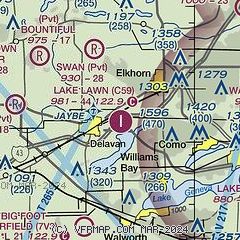
|
| Airport distance calculator |
|---|
|
|
| Sunrise and sunset |
|---|
|
Times for 26-May-2026
| | Local
(UTC-5) | | Zulu
(UTC) |
|---|
| Morning civil twilight | | 04:50 | | 09:50 |
| Sunrise | | 05:24 | | 10:24 |
| Sunset | | 20:19 | | 01:19 |
| Evening civil twilight | | 20:53 | | 01:53 |
|
| Current date and time |
|---|
| Zulu (UTC) | 26-May-2026 13:39:58 |
|---|
| Local (UTC-5) | 26-May-2026 08:39:58 |
|---|
|
| METAR |
|---|
KBUU
14nm E | 261315Z AUTO 20004KT 10SM CLR 22/10 A3008 RMK AO2 T02170103 PWINO
|
K57C
14nm NE | 261315Z AUTO 25003KT 10SM CLR 22/10 A3008 RMK AO2 T02160095
|
KJVL
18nm W | 261245Z 22003KT 10SM CLR 20/11 A3007
|
|
| TAF |
|---|
KJVL
18nm W | 261120Z 2612/2712 21007KT P6SM FEW250 FM270100 VRB03KT P6SM FEW150
|
|
| NOTAMs |
|---|
NOTAMs are issued by the DoD/FAA and will open in a separate window not controlled by AirNav.
|
|

