FAA INFORMATION EFFECTIVE 09 JULY 2026
Location
| FAA Identifier: | CBK |
| Lat/Long: | 39-25-38.8510N 101-02-47.8310W
39-25.647517N 101-02.797183W
39.4274586,-101.0466197
(estimated) |
| Elevation: | 3188.2 ft. / 971.8 m (surveyed) |
| Variation: | 08E (2000) |
| From city: | 2 miles N of COLBY, KS |
| Time zone: | UTC -5 (UTC -6 during Standard Time) |
| Zip code: | 67701 |
Airport Operations
| Airport use: | Open to the public |
| Activation date: | 12/1944 |
| Control tower: | no |
| ARTCC: | DENVER CENTER |
| FSS: | WICHITA FLIGHT SERVICE STATION |
| NOTAMs facility: | ICT (NOTAM-D service available) |
| Attendance: | SUN 1000-1700, ALL SAT-SUN ON CALL, ALL MON-FRI 0800-1600
785-460-4438.
FOR SVC CALL (785) 460-4438/460-3298. |
| Wind indicator: | lighted |
| Segmented circle: | no |
| Lights: | ACTVT REIL RWY 17 & 35; PAPI RWY 17 & 35; MIRL RWY 17/35- CTAF. |
| Beacon: | white-green (lighted land airport)
Operates sunset to sunrise. |
Airport Communications
| CTAF/UNICOM: | 122.8 |
| WX AWOS-3P: | 118.175 (785-460-4499) |
- APCH/DEP CTL SVC PRVDD BY DENVER ARTCC (ZDV) ON FREQS 132.7/226.675 (GOODLAND RCAG).
Nearby radio navigation aids
| VOR radial/distance | | VOR name | | Freq | | Var |
|---|
| GLDr073/30.0 | | GOODLAND VORTAC | | 115.10 | | 12E |
| HLCr277/39.4 | | HILL CITY VORTAC | | 113.70 | | 08E |
Airport Services
| Fuel available: | 100LL JET-A1+ |
| Parking: | hangars and tiedowns |
| Airframe service: | MAJOR |
| Powerplant service: | MAJOR |
| Bottled oxygen: | NONE |
| Bulk oxygen: | NONE |
Runway Information
Runway 17/35
| Dimensions: | 5110 x 75 ft. / 1558 x 23 m |
| Surface: | concrete/aggregate friction seal coat, in fair condition |
| Weight bearing capacity: | | Single wheel: | 30.0 | | Double wheel: | 38.0 |
|
| Runway edge lights: | medium intensity |
| RUNWAY 17 | | RUNWAY 35 |
| Latitude: | 39-26.115677N | | 39-25.274042N |
| Longitude: | 101-02.897447W | | 101-02.904835W |
| Elevation: | 3188.2 ft. | | 3155.1 ft. |
| Traffic pattern: | left | | left |
| Runway heading: | 172 magnetic, 180 true | | 352 magnetic, 000 true |
| Markings: | nonprecision, in fair condition | | nonprecision, in fair condition |
| Visual slope indicator: | 4-light PAPI on left (3.00 degrees glide path) | | 4-light PAPI on left (3.00 degrees glide path) |
| Runway end identifier lights: | yes | | yes |
| Touchdown point: | yes, no lights | | yes, no lights |
Runway 12/30
| Dimensions: | 2660 x 90 ft. / 811 x 27 m |
| Surface: | turf, in good condition |
| RUNWAY 12 | | RUNWAY 30 |
| Latitude: | 39-25.699307N | | 39-25.387493N |
| Longitude: | 101-02.893095W | | 101-02.496200W |
| Elevation: | 3170.2 ft. | | 3152.8 ft. |
| Traffic pattern: | left | | left |
| Runway heading: | 127 magnetic, 135 true | | 307 magnetic, 315 true |
| Touchdown point: | yes, no lights | | yes, no lights |
| Obstructions: | none | | 22 ft. tree, 420 ft. from runway, 125 ft. right of centerline, 19:1 slope to clear |
Runway 4/22
| Dimensions: | 2600 x 80 ft. / 792 x 24 m |
| Surface: | turf, in good condition |
| RUNWAY 4 | | RUNWAY 22 |
| Latitude: | 39-25.511025N | | 39-25.810975N |
| Longitude: | 101-02.894753W | | 101-02.500733W |
| Elevation: | 3162.3 ft. | | 3170.7 ft. |
| Traffic pattern: | left | | left |
| Runway heading: | 038 magnetic, 046 true | | 218 magnetic, 226 true |
| Touchdown point: | yes, no lights | | yes, no lights |
Airport Ownership and Management from official FAA records
| Ownership: | Publicly-owned |
| Owner: | CITY OF COLBY
585 N. FRANKLIN
COLBY, KS 67701
Phone 785-460-4410 |
| Manager: | DUSTIN STEPHENSON
5 ARPT PLAZA
COLBY, KS 67701
Phone 785-460-4438 |
Additional Remarks
| - | SEASONAL AG OPERATIONS |
| - | FOR CD CTC DENVER ARTCC AT 303-651-4257. |
Instrument Procedures
NOTE: All procedures below are presented as PDF files. If you need a reader for these files, you should download the free Adobe Reader.NOT FOR NAVIGATION. Please procure official charts for flight.
FAA instrument procedures published for use from 09 July 2026 at 0901Z to 06 August 2026 at 0900Z.
IAPs - Instrument Approach Procedures |
|---|
| RNAV (GPS) RWY 17 | |
download (238KB) |
| RNAV (GPS) RWY 35 | |
download (251KB) |
| NOTE: Special Alternate Minimums apply | |
download (139KB) |
| NOTE: Special Take-Off Minimums/Departure Procedures apply | |
download (349KB) |
Other nearby airports with instrument procedures:
KOEL - Oakley Municipal Airport (22 nm SE)
KADT - Atwood/Rawlins County Airport (25 nm N)
KGLD - Renner Field/Goodland Municipal Airport (30 nm W)
KOIN - Oberlin Municipal Airport (34 nm NE)
KSYF - Cheyenne County Municipal Airport (40 nm NW)
|
|

Road maps at:
MapQuest
Bing
Google
| Aerial photo |
|---|
WARNING: Photo may not be current or correct
 Photo by Von Rothenberger and David Readio
Photo taken 23-Jul-2006
Photo by Von Rothenberger and David Readio
Photo taken 23-Jul-2006
Do you have a better or more recent aerial photo of Shalz Field Airport that you would like to share? If so, please send us your photo.
|
| Sectional chart |
|---|
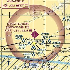
|
| Airport distance calculator |
|---|
|
|
| Sunrise and sunset |
|---|
|
Times for 24-Jul-2026
| | Local
(UTC-5) | | Zulu
(UTC) |
|---|
| Morning civil twilight | | 06:07 | | 11:07 |
| Sunrise | | 06:38 | | 11:38 |
| Sunset | | 21:03 | | 02:03 |
| Evening civil twilight | | 21:34 | | 02:34 |
|
| Current date and time |
|---|
| Zulu (UTC) | 24-Jul-2026 14:23:48 |
|---|
| Local (UTC-5) | 24-Jul-2026 09:23:48 |
|---|
|
| METAR |
|---|
| KCBK | 241355Z AUTO 19006KT 1SM BR OVC002 20/ A3007 RMK AO2 T0200////
|
|
| TAF |
|---|
KGLD
31nm W | 241127Z 2412/2512 VRB04KT 2SM BR BKN003 TEMPO 2412/2413 3/4SM BR OVC002 FM241500 VRB03KT P6SM SCT250 FM242100 05006KT P6SM SKC FM250300 17007KT P6SM SKC
|
|
| NOTAMs |
|---|
NOTAMs are issued by the DoD/FAA and will open in a separate window not controlled by AirNav.
|
|

