FAA INFORMATION EFFECTIVE 12 JUNE 2025
Location
| FAA Identifier: | H35 |
| Lat/Long: | 35-28-14.4410N 093-25-37.7660W
35-28.240683N 093-25.629433W
35.4706781,-93.4271572
(estimated) |
| Elevation: | 480.8 ft. / 146.5 m (surveyed) |
| Variation: | 04E (1995) |
| From city: | 3 miles E of CLARKSVILLE, AR |
| Time zone: | UTC -5 (UTC -6 during Standard Time) |
| Zip code: | 72830 |
Airport Operations
| Airport use: | Open to the public |
| Activation date: | 09/1941 |
| Control tower: | no |
| ARTCC: | MEMPHIS CENTER |
| FSS: | JONESBORO FLIGHT SERVICE STATION |
| NOTAMs facility: | JBR (NOTAM-D service available) |
| Attendance: | DAYLIGHT HOURS |
| Pattern altitude: | 1447.8 ft. MSL |
| Wind indicator: | lighted |
| Segmented circle: | yes |
| Lights: | PAPI RWY 9 & 27 OPR CONSLY; MIRL RWY 09/27 ON SS-SR. |
| Beacon: | white-green (lighted land airport)
Operates sunset to sunrise. |
Airport Communications
- APCH/DEP SVC PRVDD BY MEMPHIS ARTCC ON FREQS 128.475/377.15 (RUSSELLVILLE RCAG).
Nearby radio navigation aids
| NDB name | | Hdg/Dist | | Freq | | Var | | ID |
|---|
| RUSSELLVILLE | | 305/20.7 | | 379 | | 03E | | RUE | .-. ..- . |
Airport Services
| Fuel available: | 100LL JET-A
100LL:SELF SRV FUEL AVBL 24 HRS WITH CREDIT CARD (100LL & JET A). |
| Parking: | tiedowns |
| Airframe service: | MAJOR |
| Powerplant service: | MAJOR |
| Bottled oxygen: | NONE |
| Bulk oxygen: | NONE |
Runway Information
Runway 9/27
| Dimensions: | 4504 x 75 ft. / 1373 x 23 m |
| Surface: | asphalt, in excellent condition |
| Weight bearing capacity: | |
| Runway edge lights: | medium intensity |
| RUNWAY 9 | | RUNWAY 27 |
| Latitude: | 35-28.271510N | | 35-28.209830N |
| Longitude: | 093-26.081570W | | 093-25.177292W |
| Elevation: | 448.4 ft. | | 480.8 ft. |
| Traffic pattern: | left | | left |
| Runway heading: | 091 magnetic, 095 true | | 271 magnetic, 275 true |
| Markings: | nonprecision, in good condition | | nonprecision, in good condition |
| Visual slope indicator: | 2-light PAPI on left (4.00 degrees glide path) | | 2-light PAPI on left (4.00 degrees glide path)
PAPI UNUSBL BYD 8 DEGS RIGHT OF CNTRLN. |
| Touchdown point: | yes, no lights | | yes, no lights |
| Obstructions: | 70 ft. trees, 900 ft. from runway, 280 ft. left of centerline, 10:1 slope to clear | | 60 ft. tree, 900 ft. from runway, 275 ft. right of centerline, 11:1 slope to clear |
Airport Ownership and Management from official FAA records
| Ownership: | Publicly-owned |
| Owner: | CITY OF CLARKSVILLE
205 WALNUT
CLARKSVILLE, AR 72830
Phone 479-264-8408 |
| Manager: | JIM LOONEY
205 WALNUT
CLARKSVILLE, AR 72830
Phone 479-264-8408
OR 479-243-6604 FOR MAINT. |
Additional Remarks
| - | WILDLIFE ON & INVOF ARPT. |
| - | FOR CD CTC MEMPHIS ARTCC AT 901-368-8453/8449. |
Instrument Procedures
NOTE: All procedures below are presented as PDF files. If you need a reader for these files, you should download the free Adobe Reader.NOT FOR NAVIGATION. Please procure official charts for flight.
FAA instrument procedures published for use from 12 June 2025 at 0901Z to 10 July 2025 at 0900z.
IAPs - Instrument Approach Procedures |
|---|
| RNAV (GPS) RWY 09 | |
download (181KB) |
| RNAV (GPS) RWY 27 | |
download (211KB) |
| NOTE: Special Take-Off Minimums/Departure Procedures apply | |
download (131KB) |
Other nearby airports with instrument procedures:
7M5 - Ozark/Franklin County Airport (20 nm W)
KRUE - Russellville Regional Airport (21 nm SE)
32A - Danville Municipal Airport (23 nm S)
KMPJ - Petit Jean Park Airport (32 nm SE)
H34 - Huntsville Municipal Airport (40 nm NW)
|
|

Road maps at:
MapQuest
Bing
Google
| Aerial photo |
|---|
WARNING: Photo may not be current or correct
 Photo courtesy of the Arkansas Department of Aeronautics
Taken in the Spring of 2007
Photo courtesy of the Arkansas Department of Aeronautics
Taken in the Spring of 2007
Do you have a better or more recent aerial photo of Clarksville Municipal Airport that you would like to share? If so, please send us your photo.
|
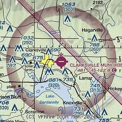
| Sectional chart |
|---|
|
| Airport distance calculator |
|---|
|
|
| Sunrise and sunset |
|---|
|
Times for 25-Jun-2025
| | Local
(UTC-5) | | Zulu
(UTC) |
|---|
| Morning civil twilight | | 05:31 | | 10:31 |
| Sunrise | | 06:01 | | 11:01 |
| Sunset | | 20:32 | | 01:32 |
| Evening civil twilight | | 21:02 | | 02:02 |
|
| Current date and time |
|---|
| Zulu (UTC) | 25-Jun-2025 13:17:27 |
|---|
| Local (UTC-5) | 25-Jun-2025 08:17:27 |
|---|
|
| METAR |
|---|
KRUE
21nm SE | 251253Z AUTO 00000KT 8SM CLR 27/23 A3017 RMK AO2 SLP206 T02670233
|
|
| TAF |
|---|
KFSM
47nm W | 251120Z 2512/2612 08004KT P6SM SKC FM251600 18007KT P6SM SCT050 FM260100 16003KT P6SM SKC
|
KFYV
49nm NW | 251120Z 2512/2612 VRB02KT P6SM SKC FM251600 18008KT P6SM SCT050 FM260100 VRB02KT P6SM FEW250
|
KHRO
50nm N | 251121Z 2512/2612 18005KT P6SM SKC FM251900 17006KT P6SM VCSH SCT050 BKN250 FM260200 VRB04KT P6SM FEW250
|
|
| NOTAMs |
|---|
NOTAMs are issued by the DoD/FAA and will open in a separate window not controlled by AirNav.
|
|


