FAA INFORMATION EFFECTIVE 16 APRIL 2026
Location
| FAA Identifier: | IGM |
| Lat/Long: | 35-15-34.1210N 113-56-16.9810W
35-15.568683N 113-56.283017W
35.2594781,-113.9380503
(estimated) |
| Elevation: | 3448.8 ft. / 1051.2 m (surveyed) |
| Variation: | 12E (2010) |
| From city: | 8 miles NE of KINGMAN, AZ |
| Time zone: | UTC -7 (year round; does not observe DST) |
| Zip code: | 86401 |
Airport Operations
| Airport use: | Open to the public |
| Activation date: | 09/1943 |
| Control tower: | no |
| ARTCC: | LOS ANGELES CENTER |
| FSS: | PRESCOTT FLIGHT SERVICE STATION |
| NOTAMs facility: | IGM (NOTAM-D service available) |
| Attendance: | MON-FRI 0600-1600, ALL SAT-SUN 0600-1400 |
| Pattern altitude: | 4248.8 ft. MSL |
| Wind indicator: | lighted |
| Segmented circle: | yes |
| Lights: | ACTVT REIL RWY 03 & 21; PAPI RWY 03 & 21; MIRL RWY 03/21 & 17/35; TWY LGTS - CTAF. |
| Beacon: | white-green (lighted land airport)
Operates sunset to sunrise. |
Airport Communications
| CTAF/UNICOM: | 122.8 |
| WX ASOS: | 119.275 (928-263-6453) |
- COMMUNICATIONS PRVDD BY PRESCOTT RADIO ON FREQ 122.1R (KINGMAN RCO).
- APCH/DEP CTL SVC PRVDD BY LOS ANGELES ARTCC (ZLC) ON 124.85/319.2 (SELIGMAN RCAG).
Nearby radio navigation aids
| VOR radial/distance | | VOR name | | Freq | | Var |
|---|
| IGM at field | | KINGMAN VOR/DME | | 108.80 | | 15E |
| PGSr206/29.2 | | PEACH SPRINGS VOR/DME | | 112.00 | | 15E |
| EEDr027/39.6 | | NEEDLES VORTAC | | 115.20 | | 15E |
Airport Services
| Fuel available: | 100LL JET-A |
| Parking: | tiedowns |
| Airframe service: | MAJOR |
| Powerplant service: | MAJOR |
| Bulk oxygen: | HIGH/LOW |
Runway Information
Runway 3/21
| Dimensions: | 6827 x 150 ft. / 2081 x 46 m |
| Surface: | asphalt, in good condition |
| Weight bearing capacity: | | PCN 20 /F/D/X/T | | Single wheel: | 45.0 | | Double wheel: | 85.0 | | Double tandem: | 125.0 | | Dual double tandem: | 265.0 |
|
| Runway edge lights: | medium intensity |
| Operational restrictions: | RWY 21 CALM WIND RWY. |
| RUNWAY 3 | | RUNWAY 21 |
| Latitude: | 35-15.089180N | | 35-15.884595N |
| Longitude: | 113-56.886307W | | 113-55.916027W |
| Elevation: | 3411.4 ft. | | 3394.6 ft. |
| Traffic pattern: | left | | left |
| Runway heading: | 033 magnetic, 045 true | | 213 magnetic, 225 true |
| Declared distances: | TORA:6827 TODA:6827 ASDA:6827 LDA:6827 | | TORA:6827 TODA:6827 ASDA:6827 LDA:6827 |
| Markings: | nonprecision, in good condition | | nonprecision, in good condition |
| Visual slope indicator: | 4-light PAPI on left (3.00 degrees glide path) | | 4-light PAPI on left (3.00 degrees glide path) |
| Runway end identifier lights: | yes | | yes |
| Touchdown point: | yes, no lights | | yes, no lights |
Runway 17/35
| Dimensions: | 6725 x 75 ft. / 2050 x 23 m |
| Surface: | asphalt, in good condition |
| Weight bearing capacity: | | PCN 3 /F/D/Y/T | | Single wheel: | 22.0 | | Double wheel: | 60.0 |
|
| Runway edge lights: | medium intensity |
| RUNWAY 17 | | RUNWAY 35 |
| Latitude: | 35-16.205865N | | 35-15.097580N |
| Longitude: | 113-56.162702W | | 113-56.163347W |
| Elevation: | 3360.0 ft. | | 3448.8 ft. |
| Traffic pattern: | left | | left |
| Runway heading: | 168 magnetic, 180 true | | 348 magnetic, 000 true |
| Declared distances: | TORA:6725 TODA:6725 ASDA:6725 LDA:6725 | | TORA:6725 TODA:6725 ASDA:6725 LDA:6725 |
| Markings: | basic, in good condition | | basic, in good condition |
| Visual slope indicator: | 2-light PAPI on left (3.00 degrees glide path) | | 2-light PAPI on left (3.00 degrees glide path) |
| Runway end identifier lights: | no | | no |
| Touchdown point: | yes, no lights | | yes, no lights |
Airport Ownership and Management from official FAA records
| Ownership: | Publicly-owned |
| Owner: | CITY OF KINGMAN
7000 FLIGHTLINE DR
KINGMAN, AZ 86401
Phone 928-757-2134 |
| Manager: | DOUG BRECKENRIDGE
7000 FLIGHTLINE DR.
KINGMAN, AZ 86401
Phone 928-757-2134 |
Additional Remarks
| A30A-21 | DSTC RMNG SIGNS L SIDE. |
| A30A-03 | DSTC RMNG SIGNS R SIDE. |
| - | ULTRALIGHT & MODEL ACFT ACT NW. |
| - | FOR CD IF UNA TO CTC ON FSS FREQ, CTC LOS ANGELES ARTCC AT 661-575-2079. |
Instrument Procedures
NOTE: All procedures below are presented as PDF files. If you need a reader for these files, you should download the free Adobe Reader.NOT FOR NAVIGATION. Please procure official charts for flight.
FAA instrument procedures published for use from 16 April 2026 at 0901Z to 14 May 2026 at 0900Z.
IAPs - Instrument Approach Procedures |
|---|
| RNAV (GPS) RWY 03 | |
download (339KB) |
| RNAV (GPS) Y RWY 21 | |
download (317KB) |
| RNAV (GPS) Z RWY 21 | |
download (299KB) |
| VOR/DME RWY 21 | |
download (341KB) |
| NOTE: Special Alternate Minimums apply | |
download (119KB) |
| NOTE: Special Take-Off Minimums/Departure Procedures apply | |
download (348KB) |
Other nearby airports with instrument procedures:
KIFP - Laughlin/Bullhead International Airport (31 nm W)
KEED - Needles Airport (45 nm SW)
KHII - Lake Havasu City Airport (46 nm SW)
KBVU - Boulder City Municipal Airport (61 nm NW)
P20 - Avi Suquilla Airport (69 nm S)
|
|

Road maps at:
MapQuest
Bing
Google
| Aerial photo |
|---|
WARNING: Photo may not be current or correct
 Photo by Vicki Eifert
Photo taken 22-Aug-2016
looking southwest.
Photo by Vicki Eifert
Photo taken 22-Aug-2016
looking southwest.
Do you have a better or more recent aerial photo of Kingman Airport that you would like to share? If so, please send us your photo.
|
| Sectional chart |
|---|
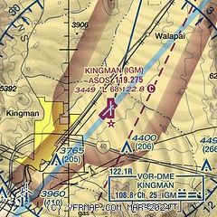
|
| Airport distance calculator |
|---|
|
|
| Sunrise and sunset |
|---|
|
Times for 26-Apr-2026
| | Local
(UTC-7) | | Zulu
(UTC) |
|---|
| Morning civil twilight | | 05:24 | | 12:24 |
| Sunrise | | 05:51 | | 12:51 |
| Sunset | | 19:16 | | 02:16 |
| Evening civil twilight | | 19:43 | | 02:43 |
|
| Current date and time |
|---|
| Zulu (UTC) | 26-Apr-2026 08:26:34 |
|---|
| Local (UTC-7) | 26-Apr-2026 01:26:34 |
|---|
|
| METAR |
|---|
| KIGM | 260751Z AUTO 22016G34KT 10SM -RA BKN048 OVC070 12/04 A2975 RMK AO2 PK WND 23044/0706 RAB05 SLP023 P0000 T01170044
|
|
| TAF |
|---|
KIFP
22nm SW | 260520Z 2606/2706 17010KT P6SM VCSH SCT080 BKN120 FM261000 16010KT P6SM SCT080 BKN120 FM261600 19018G28KT P6SM SCT080 BKN120 FM270300 20010KT P6SM FEW120 FM270500 16007KT P6SM FEW120
|
|
| NOTAMs |
|---|
NOTAMs are issued by the DoD/FAA and will open in a separate window not controlled by AirNav.
|
|

