FAA INFORMATION EFFECTIVE 14 MAY 2026
Location
| FAA Identifier: | ALO |
| Lat/Long: | 42-33-30.4170N 092-24-03.6840W
42-33.506950N 092-24.061400W
42.5584492,-92.4010233
(estimated) |
| Elevation: | 873 ft. / 266.1 m (surveyed) |
| Variation: | 00E (2020) |
| From city: | 4 miles NW of WATERLOO, IA |
| Time zone: | UTC -5 (UTC -6 during Standard Time) |
| Zip code: | 50703 |
Airport Operations
| Airport use: | Open to the public |
| Activation date: | 05/1947 |
| Control tower: | yes |
| ARTCC: | MINNEAPOLIS CENTER |
| FSS: | FORT DODGE FLIGHT SERVICE STATION |
| NOTAMs facility: | ALO (NOTAM-D service available) |
| Attendance: | 0500-2100 |
| Wind indicator: | lighted |
| Segmented circle: | no |
| Lights: | WHEN ATCT CLSD ACTVT MALSR RWY 12; MALS RWY 30; VASI RWY 18; PAPI RWY 36; MIRL RWYS 18/36, AND HIRL RWY 12/30 - CTAF. |
| Beacon: | white-green (lighted land airport)
Operates sunset to sunrise. |
| Fire and rescue: | ARFF index A |
| Airline operations: | CLSD TO UNSKED ACR OPNS WITH MORE THAN 10 PSGR SEATS EXCP 72 HRS PPR AMGR. CALL AMGR 319-291-4483. CELL 319-529-1388 ARFF INDEX B PROVIDED. ARFF INDEX C AVBL ON 72 HRS REQ. AIR CARRIER OPS OVER 9 PSGR SEATS NOT AUTH OVER 15 MINUTES BEFORE OR AFTER SKED ARR OR DEP TIMES EXCP WITH PRIOR COORD WITH AMGR. |
Airport Communications
| CTAF: | 125.075 |
| UNICOM: | 122.95 |
| ATIS: | 120.65 |
| WX ASOS: | 120.65 (319-209-4125) |
| WATERLOO GROUND: | 121.9 269.1 [0600-2000] |
| WATERLOO TOWER: | 125.075 257.8 [0600-2000] |
| DES MOINES APPROACH: | 118.9 |
| DES MOINES DEPARTURE: | 118.9 |
| CLEARANCE DELIVERY: | 121.9 |
| ANG OPS: | 142.6 231.55 36.7FM |
| EMERG: | 121.5 243.0 |
- APCH/DEP SVC PRVDD BY MINNEAPOLIS ARTCC ON FREQS 118.9/251.15 (REMOTED FROM WATERLOO) WHEN DES MOINES APCH CTL CLSD.
Nearby radio navigation aids
| VOR radial/distance | | VOR name | | Freq | | Var |
|---|
| ALO at field | | WATERLOO VOR/DME | | 112.20 | | 00E |
Airport Services
| Fuel available: | 100LL JET-A
100LL:FUEL AVBL ON REQ. FEE FOR SVCS. |
| Parking: | hangars and tiedowns |
| Airframe service: | MAJOR |
| Powerplant service: | MAJOR |
| Bottled oxygen: | HIGH/LOW |
| Bulk oxygen: | HIGH/LOW |
Runway Information
Runway 12/30
| Dimensions: | 8399 x 150 ft. / 2560 x 46 m |
| Surface: | asphalt/grooved, in good condition |
| Weight bearing capacity: | | Single wheel: | 120.0 | | Double wheel: | 250.0 | | Double tandem: | 550.0 | | Dual double tandem: | 1120.0 |
|
| Runway edge lights: | high intensity |
| RUNWAY 12 | | RUNWAY 30 |
| Latitude: | 42-33.962148N | | 42-33.114882N |
| Longitude: | 092-24.716865W | | 092-23.238852W |
| Elevation: | 872.6 ft. | | 867.0 ft. |
| Traffic pattern: | left | | left |
| Runway heading: | 128 | | 308 |
| Declared distances: | TORA:8399 TODA:8399 ASDA:8399 LDA:8399 | | TORA:8399 TODA:8399 ASDA:8399 LDA:8399 |
| Markings: | precision, in good condition | | nonprecision, in good condition |
| Visual slope indicator: | 4-light PAPI on left (3.00 degrees glide path) | | 4-box VASI on left (3.00 degrees glide path) |
| RVR equipment: | touchdown | | rollout |
| Approach lights: | MALSR: 1,400 foot medium intensity approach lighting system with runway alignment indicator lights | | MALS: 1,400 foot medium intensity approach lighting system |
| Touchdown point: | yes, no lights | | yes, no lights |
| Instrument approach: | ILS/DME | | |
| Obstructions: | 107 ft. tree, 5200 ft. from runway, 1000 ft. left of centerline, 46:1 slope to clear | | none |
Runway 18/36
| Dimensions: | 6003 x 150 ft. / 1830 x 46 m |
| Surface: | asphalt/concrete/grooved, in good condition |
| Weight bearing capacity: | | Single wheel: | 120.0 | | Double wheel: | 222.0 | | Double tandem: | 377.0 | | Dual double tandem: | 889.0 |
|
| Runway edge lights: | medium intensity |
| RUNWAY 18 | | RUNWAY 36 |
| Latitude: | 42-33.952305N | | 42-32.973120N |
| Longitude: | 092-24.087907W | | 092-24.268858W |
| Elevation: | 870.8 ft. | | 868.0 ft. |
| Traffic pattern: | left | | left |
| Runway heading: | 188 | | 008 |
| Declared distances: | TORA:6003 TODA:6003 ASDA:6003 LDA:6003 | | TORA:6003 TODA:6003 ASDA:6003 LDA:6003 |
| Markings: | nonprecision, in fair condition | | nonprecision, in fair condition |
| Visual slope indicator: | 4-box VASI on left (3.00 degrees glide path) | | 4-light PAPI on left (3.00 degrees glide path) |
| Runway end identifier lights: | yes | | yes |
| Touchdown point: | yes, no lights | | yes, no lights |
| Obstructions: | 75 ft. tree, 1875 ft. from runway, 450 ft. left of centerline, 22:1 slope to clear | | 50 ft. tree, 2300 ft. from runway, 250 ft. left of centerline, 42:1 slope to clear |
Airport Ownership and Management from official FAA records
| Ownership: | Publicly-owned |
| Owner: | CITY OF WATERLOO
715 MULBERRY
WATERLOO, IA 50701
Phone 319-291-4323 |
| Manager: | MR. STEVEN KJERGAARD
2790 LIVINGSTON LANE
WATERLOO, IA 50703
Phone 319-291-4483 |
Additional Remarks
| A39-18/36 | PCR VALUE: 202/F/B/X/T |
| A39-12/30 | PCR VALUE: 513/F/B/X/T |
| - | FOR CD IF UNA ON 121.9 CTC WATERLOO ATCT AT 319-233-4835. WHEN WATERLOO ATCT CLSD, FOR CD CTC MINNEAPOLIS ARTCC AT 651-463-5588. |
| - | ACR NA TWY A EAST OF RWY 12/30. |
| - | TWY A LGT BTN RWY 12/30 & ARMY AVN SUPPORT RAMP NA. |
| - | BIRDS ON & INVOF ARPT. |
| - | RWY 30 IS CALM WIND RWY. |
| - | WHEN DEPARTING ALL RWYS, ENDS OF OTHER RWYS NOT VISIBLE. |
| - | WHEN ATCT CLSD & DURG SNOW EVENTS, ALL ARR/DEP ACFT ANNC THEIR INTNS ON CTAF 5 MIN PRIOR TO USING THE RWYS. |
| - | PERSONNEL & EQUP PERFORMING SNOW REMOVAL OPNS WILL MONITOR CTAF. |
| - | ARNG: ARNG OPS CTC DSN 431-5520, C319-234-1372. |
| - | ARPT SFC CONDS UNMON 2200-0430 DAILY. |
Instrument Procedures
NOTE: All procedures below are presented as PDF files. If you need a reader for these files, you should download the free Adobe Reader.NOT FOR NAVIGATION. Please procure official charts for flight.
FAA instrument procedures published for use from 14 May 2026 at 0901Z to 11 June 2026 at 0900Z.
IAPs - Instrument Approach Procedures |
|---|
| ILS OR LOC RWY 12 **CHANGED** | |
download (307KB) |
| RNAV (GPS) RWY 12 | |
download (242KB) |
| RNAV (GPS) RWY 18 | |
download (232KB) |
| RNAV (GPS) RWY 30 | |
download (246KB) |
| RNAV (GPS) RWY 36 | |
download (246KB) |
| LOC BC RWY 30 **CHANGED** | |
download (270KB) |
| VOR RWY 12 **CHANGED** | |
download (177KB) |
| VOR RWY 18 **CHANGED** | |
download (174KB) |
| NOTE: Special Alternate Minimums apply | |
download (128KB) |
| NOTE: Special Take-Off Minimums/Departure Procedures apply | |
download (421KB) |
Other nearby airports with instrument procedures:
C25 - Waverly Municipal Airport (12 nm NW)
KOLZ - Oelwein Municipal Airport (20 nm E)
KIIB - James H Connell Field at Independence Municipal Airport (21 nm E)
KVTI - Vinton Veterans Memorial Airpark (26 nm SE)
KCCY - Northeast Iowa Regional Airport (32 nm N)
|
|

Road maps at:
MapQuest
Bing
Google
| Aerial photo |
|---|
WARNING: Photo may not be current or correct
 Looking south-southeast.
Do you have a better or more recent aerial photo of Waterloo Regional Airport that you would like to share? If so, please send us your photo.
|
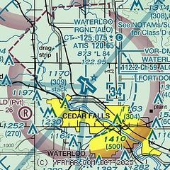
| Sectional chart |
|---|
|
 Download PDF
of official airport diagram from the FAA
| Airport distance calculator |
|---|
|
|
| Sunrise and sunset |
|---|
|
Times for 31-May-2026
| | Local
(UTC-5) | | Zulu
(UTC) |
|---|
| Morning civil twilight | | 05:02 | | 10:02 |
| Sunrise | | 05:36 | | 10:36 |
| Sunset | | 20:38 | | 01:38 |
| Evening civil twilight | | 21:12 | | 02:12 |
|
| Current date and time |
|---|
| Zulu (UTC) | 31-May-2026 16:54:11 |
|---|
| Local (UTC-5) | 31-May-2026 11:54:11 |
|---|
|
| METAR |
|---|
| KALO | 311606Z 10010KT 7SM VCTS -RA BKN095 OVC110 14/13 A3003 RMK AO2 P0001 T01440128
|
|
| TAF |
|---|
| KALO | 311446Z 3115/0112 11011KT 6SM -SHRA BKN060 BKN110 TEMPO 3115/3117 3SM -SHRA BKN027 FM311700 13012KT P6SM BKN080 FM312000 12011KT P6SM BKN045 FM010100 11008KT P6SM BKN080
|
|
| NOTAMs |
|---|
NOTAMs are issued by the DoD/FAA and will open in a separate window not controlled by AirNav.
|
|


