FAA INFORMATION EFFECTIVE 11 JUNE 2026
Location
| FAA Identifier: | ASH |
| Lat/Long: | 42-46-56.6900N 071-30-50.7400W
42-46.944833N 071-30.845667W
42.7824139,-71.5140944
(estimated) |
| Elevation: | 200.4 ft. / 61.1 m (surveyed) |
| Variation: | 16W (1995) |
| From city: | 3 miles NW of NASHUA, NH |
| Time zone: | UTC -4 (UTC -5 during Standard Time) |
| Zip code: | 03063 |
Airport Operations
| Airport use: | Open to the public |
| Activation date: | 03/1947 |
| Control tower: | yes |
| ARTCC: | BOSTON CENTER |
| FSS: | BANGOR FLIGHT SERVICE STATION |
| NOTAMs facility: | ASH (NOTAM-D service available) |
| Attendance: | 0700-2100 |
| Wind indicator: | lighted |
| Segmented circle: | no |
| Lights: | WHEN TWR CLSD ACTVT MALSR RWY 14; REIL RWY 32; PAPI RWY 14; HIRL RWY 14/32 - CTAF. |
| Beacon: | white-green (lighted land airport)
Operates sunset to sunrise. |
| Landing fee: | no, FOR ACFT OVR 12500 LBS, FEE PER 1000 LBS. |
Airport Communications
| CTAF: | 133.2 |
| ATIS: | 125.1 |
| WX AWOS-3PT: | 125.1 (603-578-0473) |
| NASHUA GROUND: | 121.8 [0700-2100] |
| NASHUA TOWER: | 133.2 [0700-2100] |
| BOSTON APPROACH: | 124.9 |
| BOSTON DEPARTURE: | 124.9 |
| CLEARANCE DELIVERY: | 121.8 ;WHEN ASH TWR CLSD 121.8 |
| WX ASOS at MHT (10 nm N): | 119.55 (603-626-6902) |
| WX ASOS at FIT (17 nm SW): | 135.175 (978-343-9121) |
| WX ASOS at LWM (18 nm E): | PHONE 978-687-8017 |
Nearby radio navigation aids
| VOR radial/distance | | VOR name | | Freq | | Var |
|---|
| CONr189/26.4 | | CONCORD VOR/DME | | 112.90 | | 15W |
| GDMr073/27.9 | | GARDNER VOR/DME | | 116.95 | | 14W |
| BOSr334/34.5 | | BOSTON VOR/DME | | 112.70 | | 16W |
| NDB name | | Hdg/Dist | | Freq | | Var | | ID |
|---|
| FITZY | | 187/4.9 | | 209 | | 15W | | MJ | -- .--- |
| ROLLINS | | 245/39.9 | | 260 | | 16W | | ESG | . ... --. |
Airport Services
| Fuel available: | 100LL JET-A1+ |
| Parking: | hangars and tiedowns |
| Airframe service: | MAJOR |
| Powerplant service: | MAJOR |
| Bottled oxygen: | HIGH/LOW |
| Bulk oxygen: | HIGH/LOW |
Runway Information
Runway 14/32
| Dimensions: | 6000 x 100 ft. / 1829 x 30 m |
| Surface: | asphalt/grooved, in excellent condition |
| Weight bearing capacity: | | Single wheel: | 62.0 | | Double wheel: | 80.0 | | Double tandem: | 133.0 |
|
| Runway edge lights: | high intensity |
| RUNWAY 14 | | RUNWAY 32 |
| Latitude: | 42-47.211637N | | 42-46.677985N |
| Longitude: | 071-31.409978W | | 071-30.281520W |
| Elevation: | 200.4 ft. | | 192.0 ft. |
| Traffic pattern: | left | | left |
| Runway heading: | 139 magnetic, 123 true | | 319 magnetic, 303 true |
| Displaced threshold: | no | | 350 ft. |
| Declared distances: | TORA:6000 TODA:6000 ASDA:5650 LDA:5650 | | TORA:6000 TODA:6000 ASDA:6000 LDA:5650 |
| Markings: | precision, in good condition | | nonprecision, in good condition |
| Visual slope indicator: | 4-light PAPI on right (3.00 degrees glide path) | | 4-light PAPI on left (3.00 degrees glide path) |
| Approach lights: | MALSR: 1,400 foot medium intensity approach lighting system with runway alignment indicator lights | | |
| Runway end identifier lights: | | | yes |
| Touchdown point: | yes, no lights | | yes, no lights |
| Instrument approach: | ILS | | |
| Obstructions: | 30 ft. pole, lighted, 1487 ft. from runway, 370 ft. left of centerline, 42:1 slope to clear
TREES LCTD ALG RAIL LN N OF RWY. | | 63 ft. tree, 1351 ft. from runway, 287 ft. left of centerline, 18:1 slope to clear
APCH SLOPE 44:1 TO DTHR. |
Airport Ownership and Management from official FAA records
| Ownership: | Publicly-owned |
| Owner: | NASHUA AIRPORT AUTHORITY
93 PERIMETER RD
NASHUA, NH 03063
Phone 603-882-0661 |
| Manager: | CHRIS LYNCH
93 PERIMETER RD
NASHUA, NH 03063
Phone 603-882-0661 |
Additional Remarks
| - | ARPT HAS VOLUNTARY NOISE ABATEMENT PROCS. CTC AMGR FOR DETAILS. |
| - | MIGRATORY BIRDS & WILDLIFE ON & INVOF ARPT. |
| - | RAMP BTN TWY D & TWY E CLSD TO ACFT WITH WINGSPAN GTR THAN 48 FT UNLESS AUZD BY ATCT. |
Instrument Procedures
NOTE: All procedures below are presented as PDF files. If you need a reader for these files, you should download the free Adobe Reader.NOT FOR NAVIGATION. Please procure official charts for flight.
FAA instrument procedures published for use from 11 June 2026 at 0901Z to 09 July 2026 at 0900z.
IAPs - Instrument Approach Procedures |
|---|
| ILS OR LOC RWY 14 **CHANGED** | |
download (244KB) |
| RNAV (GPS) RWY 14 **CHANGED** | |
download (216KB) |
| RNAV (GPS) RWY 32 **CHANGED** | |
download (228KB) |
| NOTE: Special Alternate Minimums apply | |
download (138KB) |
| NOTE: Special Take-Off Minimums/Departure Procedures apply | |
download (488KB) |
Other nearby airports with instrument procedures:
KMHT - Manchester Boston Regional Airport (10 nm N)
KFIT - Fitchburg Municipal Airport (17 nm SW)
KLWM - Lawrence Municipal Airport (18 nm E)
6B6 - Minute Man Air Field (19 nm S)
KBED - Laurence G Hanscom Field Airport (21 nm SE)
|
|

Road maps at:
MapQuest
Bing
Google
| Aerial photo |
|---|
WARNING: Photo may not be current or correct
 Photo by Nick Tognacci
Photo taken 12-Nov-2016
looking west.
Photo by Nick Tognacci
Photo taken 12-Nov-2016
looking west.
Do you have a better or more recent aerial photo of Boire Field Airport that you would like to share? If so, please send us your photo.
|
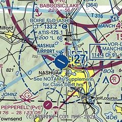
| Sectional chart |
|---|
|
CAUTION: Diagram may not be current
 Download PDF
of official airport diagram from the FAA
| Airport distance calculator |
|---|
|
|
| Sunrise and sunset |
|---|
|
Times for 12-Jun-2026
| | Local
(UTC-4) | | Zulu
(UTC) |
|---|
| Morning civil twilight | | 04:33 | | 08:33 |
| Sunrise | | 05:08 | | 09:08 |
| Sunset | | 20:24 | | 00:24 |
| Evening civil twilight | | 20:59 | | 00:59 |
|
| Current date and time |
|---|
| Zulu (UTC) | 12-Jun-2026 15:44:54 |
|---|
| Local (UTC-4) | 12-Jun-2026 11:44:54 |
|---|
|
| METAR |
|---|
| KASH | 121456Z VRB04KT 10SM CLR 28/23 A2967 RMK AO2 RAB09E20 SLP044 P0000 60000 T02830233 58003
|
KMHT
10nm N | 121453Z 00000KT 10SM FEW030 BKN140 29/22 A2965 RMK AO2 SLP049 60000 T02940217 58006
|
KLWM
17nm E | 121454Z VRB04KT 10SM FEW080 29/22 A2967 RMK AO2 SLP046 T02940222 58005
|
KFIT
17nm SW | 121452Z AUTO 33005KT 10SM CLR 30/21 A2967 RMK AO2 SLP046 T03000211 58007
|
|
| TAF |
|---|
KMHT
10nm N | 121120Z 1212/1312 VRB04KT P6SM VCSH SCT030 BKN060 BKN100 TEMPO 1212/1213 3SM -SHRA FM130000 VRB04KT P6SM SCT050 SCT150 BKN200
|
|
| NOTAMs |
|---|
NOTAMs are issued by the DoD/FAA and will open in a separate window not controlled by AirNav.
|
|


