FAA INFORMATION EFFECTIVE 17 APRIL 2025
Location
| FAA Identifier: | BLF |
| Lat/Long: | 37-17-45.4141N 081-12-27.0679W
37-17.756902N 081-12.451132W
37.2959484,-81.2075189
(estimated) |
| Elevation: | 2856.7 ft. / 870.7 m (surveyed) |
| Variation: | 07W (2010) |
| From city: | 3 miles NE of BLUEFIELD, WV |
| Time zone: | UTC -4 (UTC -5 during Standard Time) |
| Zip code: | 24701 |
Airport Operations
| Airport use: | Open to the public |
| Activation date: | 05/1954 |
| Control tower: | no |
| ARTCC: | INDIANAPOLIS CENTER |
| FSS: | ELKINS FLIGHT SERVICE STATION [703-724-4288] |
| NOTAMs facility: | BLF (NOTAM-D service available) |
| Attendance: | 0600-2100
ARPT UNATND CHRISTMAS & NEW YEARS. FOR SVCS CALL 304-921-3417 (LINE STAFF CELL). |
| Wind indicator: | lighted |
| Segmented circle: | no |
| Lights: | ACTVT REIL RWY 05 & 23; PAPI RWY 05 & 23; HIRL RWY 05/23; TWY LIGHTS - CTAF. |
| Beacon: | white-green (lighted land airport)
Operates sunset to sunrise. |
Airport Communications
| CTAF: | 122.9 |
| WX ASOS: | 132.725 (304-327-5766) |
- APCH/DEP SVC PRVDD BY INDIANAPOLIS ARTCC ON FREQS 126.575/257.85 (BLUEFIELD RCAG).
Nearby radio navigation aids
| VOR radial/distance | | VOR name | | Freq | | Var |
|---|
| BLF at field | | BLUEFIELD VOR/DME | | 115.05 | | 03W |
| PSKr304/26.7 | | PULASKI VORTAC | | 116.80 | | 06W |
| NDB name | | Hdg/Dist | | Freq | | Var | | ID |
|---|
| TECH | | 286/38.8 | | 368 | | 08W | | TEC | - . -.-. |
Airport Services
| Fuel available: | 100LL JET-A JET-A+
100LL:24 HR SELF-SERVE FUEL. FUEL ALSO AVBL BY TRUCK DRG ATND HRS OR AFTR HRS BY PRIOR ARGMNT, $75 CALL-OUT FEE. LINE OFC PH 304-327-8440. |
| Parking: | hangars and tiedowns |
| Airframe service: | MAJOR
ROTARY WING REPAIRS ONLY. FIXED WING RPRS AVBL ON CALL, CTC AMGR. |
| Powerplant service: | MAJOR
ROTARY WING REPAIRS ONLY. FIXED WING RPRS AVBL ON CALL, CTC AMGR. |
| Bottled oxygen: | NONE |
| Bulk oxygen: | NONE |
Runway Information
Runway 5/23
| Dimensions: | 4743 x 100 ft. / 1446 x 30 m |
| Surface: | asphalt/grooved, in good condition |
| Weight bearing capacity: | | Single wheel: | 30.0 | | Double wheel: | 48.0 |
|
| Runway edge lights: | high intensity |
| RUNWAY 5 | | RUNWAY 23 |
| Latitude: | 37-17.465930N | | 37-18.047872N |
| Longitude: | 081-12.777540W | | 081-12.124723W |
| Elevation: | 2850.2 ft. | | 2856.4 ft. |
| Traffic pattern: | left | | left |
| Runway heading: | 049 magnetic, 042 true | | 229 magnetic, 222 true |
| Declared distances: | TORA:4743 TODA:4743 ASDA:4743 LDA:4743 | | TORA:4743 TODA:4743 ASDA:4743 LDA:4743 |
| Markings: | nonprecision, in fair condition | | precision, in fair condition |
| Visual slope indicator: | 4-light PAPI on left (3.00 degrees glide path) | | 4-light PAPI on left (3.00 degrees glide path) |
| Runway end identifier lights: | yes | | yes |
| Touchdown point: | yes, no lights | | yes, no lights |
| Instrument approach: | | | ILS |
| Obstructions: | 35 ft. trees, 201 ft. from runway, 330 ft. right of centerline
35 FT TREES, UP TO 199 FT DSTC, 300 FT RIGHT. | | 40 ft. trees, 201 ft. from runway, 300 ft. right of centerline
40 FT TREES, 0 FT DSTC, 300 FT R. |
Airport Ownership and Management from official FAA records
| Ownership: | Publicly-owned |
| Owner: | MERCER CO ARPT AUTH INC
300 MARKELL DR. STE 201
BLUEFIELD, WV 24701
Phone 304-327-5308 |
| Manager: | JIM PILKINS
300 MARKELL DR. STE 201
BLUEFIELD, WV 24701
Phone 304-327-5308
MGR CELL 304-921-3417. |
Additional Remarks
| - | MOWING IN PROGRESS APR-NOV ALL SFCS. |
| - | DEER & BIRDS ON & INVOF ARPT. |
| - | RWY 23 HAS STEEP DROP-OFF 320 FT FM THR 0B, 280 FT L AND R. |
| - | RWY 05 HAS STEEP DROP-OFF 175 FT FM THR L SIDE. |
| - | FOR CD IF UNA TO CTC ON FSS FREQ, CTC INDIANAPOLIS ARTCC AT 317-247-2411. |
Instrument Procedures
NOTE: All procedures below are presented as PDF files. If you need a reader for these files, you should download the free Adobe Reader.NOT FOR NAVIGATION. Please procure official charts for flight.
FAA instrument procedures published for use from 17 April 2025 at 0901Z to 15 May 2025 at 0900z.
IAPs - Instrument Approach Procedures |
|---|
| ILS OR LOC RWY 23 **CHANGED** | |
download (272KB) |
| RNAV (GPS) RWY 05 | |
download (205KB) |
| RNAV (GPS) RWY 23 | |
download (248KB) |
| VOR RWY 23 | |
download (241KB) |
| NOTE: Special Alternate Minimums apply | |
download (145KB) |
| NOTE: Special Take-Off Minimums/Departure Procedures apply | |
download (149KB) |
Other nearby airports with instrument procedures:
I16 - Kee Field Airport (25 nm NW)
KMKJ - Mountain Empire Airport (25 nm S)
KPSK - New River Valley Airport (27 nm E)
KBKW - Raleigh County Memorial Airport (30 nm N)
KJFZ - Tazewell County Airport (31 nm SW)
|
|

Road maps at:
MapQuest
Bing
Google
| Aerial photo |
|---|
WARNING: Photo may not be current or correct
 Photo courtesy of AirNav, LLC
Photo taken 20-May-2012
looking south.
Photo courtesy of AirNav, LLC
Photo taken 20-May-2012
looking south.
Do you have a better or more recent aerial photo of Mercer County Airport that you would like to share? If so, please send us your photo.
|
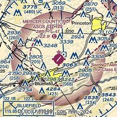
| Sectional chart |
|---|
|
| Airport distance calculator |
|---|
|
|
| Sunrise and sunset |
|---|
|
Times for 05-May-2025
| | Local
(UTC-4) | | Zulu
(UTC) |
|---|
| Morning civil twilight | | 05:58 | | 09:58 |
| Sunrise | | 06:27 | | 10:27 |
| Sunset | | 20:17 | | 00:17 |
| Evening civil twilight | | 20:45 | | 00:45 |
|
| Current date and time |
|---|
| Zulu (UTC) | 05-May-2025 11:29:48 |
|---|
| Local (UTC-4) | 05-May-2025 07:29:48 |
|---|
|
| METAR |
|---|
| KBLF | 051102Z AUTO 12003KT M1/4SM FG VV002 06/06 A2993 RMK AO2 T00560056
|
|
| TAF |
|---|
| KBLF | 050836Z 0509/0606 25003KT P6SM SCT040 BKN060 TEMPO 0509/0511 1 1/2SM BR FM051300 VRB03KT P6SM SCT025 FM051500 21008G18KT P6SM BKN040 FM060000 25004KT P6SM BKN050
|
|
| NOTAMs |
|---|
NOTAMs are issued by the DoD/FAA and will open in a separate window not controlled by AirNav.
|
|


