FAA INFORMATION EFFECTIVE 19 MARCH 2026
Location
| FAA Identifier: | FRR |
| Lat/Long: | 38-55-03.0440N 078-15-12.1440W
38-55.050733N 078-15.202400W
38.9175122,-78.2533733
(estimated) |
| Elevation: | 703.6 ft. / 214.5 m (surveyed) |
| Variation: | 10W (2005) |
| From city: | 3 miles W of FRONT ROYAL, VA |
| Time zone: | UTC -4 (UTC -5 during Standard Time) |
| Zip code: | 22630 |
Airport Operations
| Airport use: | Open to the public |
| Activation date: | 08/1944 |
| Control tower: | no |
| ARTCC: | WASHINGTON CENTER |
| FSS: | LEESBURG FLIGHT SERVICE STATION |
| NOTAMs facility: | DCA (NOTAM-D service available) |
| Attendance: | MAY-SEP 0800-1700, OCT-APR 0900-1600 |
| Wind indicator: | lighted |
| Segmented circle: | no |
| Lights: | ACTVT MIRL RWY 10/28 - CTAF. |
| Beacon: | white-green (lighted land airport)
Operates sunset to sunrise. |
Airport Communications
| CTAF/UNICOM: | 123.0 |
| WX AWOS-3: | 121.85 (540-635-5377) |
| POTOMAC APPROACH: | 120.45 |
| POTOMAC DEPARTURE: | 120.45 |
| HYPER STAR: | 133.0 |
| TRSTN STAR: | 126.75 |
| WX AWOS-3 at OKV (14 nm N): | 124.85 (540-662-6970) |
| WX AWOS-3 at LUA (19 nm SW): | 118.275 (540-743-1148) |
Nearby radio navigation aids
| VOR radial/distance | | VOR name | | Freq | | Var |
|---|
| LDNr335/4.4 | | LINDEN VORTAC | | 114.30 | | 06W |
| CSNr318/24.6 | | CASANOVA VORTAC | | 116.30 | | 06W |
| MRBr221/33.8 | | MARTINSBURG VORTAC | | 112.10 | | 07W |
| AMLr276/36.7 | | ARMEL VOR/DME | | 113.50 | | 08W |
| ESLr124/39.0 | | KESSEL VOR/DME | | 110.80 | | 06W |
| NDB name | | Hdg/Dist | | Freq | | Var | | ID |
|---|
| CAVERNS | | 047/16.6 | | 245 | | 09W | | LUA | .-.. ..- .- |
| NAILR | | 340/32.2 | | 351 | | 10W | | MSQ | -- ... --.- |
Airport Services
| Fuel available: | 100LL |
| Parking: | hangars and tiedowns |
| Airframe service: | MINOR |
| Powerplant service: | MINOR |
| Bottled oxygen: | NONE |
| Bulk oxygen: | NONE |
Runway Information
Runway 10/28
| Dimensions: | 3008 x 75 ft. / 917 x 23 m |
| Surface: | asphalt, in good condition |
| Weight bearing capacity: | |
| Runway edge lights: | medium intensity |
| RUNWAY 10 | | RUNWAY 28 |
| Latitude: | 38-55.036688N | | 38-55.064770N |
| Longitude: | 078-15.519002W | | 078-14.885810W |
| Elevation: | 693.0 ft. | | 703.5 ft. |
| Traffic pattern: | left
RY 10 RIGHT TFC FOR GYROCOPTERS, ULTRALIGHTS & GLIDERS. | | left
RY 28 RIGHT TFC FOR GYROCOPTERS, ULTRALIGHTS & GLIDERS. |
| Runway heading: | 097 magnetic, 087 true | | 277 magnetic, 267 true |
| Markings: | basic, in fair condition | | nonprecision, in fair condition |
| Visual slope indicator: | panels that may or may not be lighted, on right (3.00 degrees glide path) | | panels that may or may not be lighted, on left (3.00 degrees glide path) |
| Runway end identifier lights: | no | | no |
| Touchdown point: | yes, no lights | | yes, no lights |
| Obstructions: | 24 ft. road, 350 ft. from runway, 131 ft. left of centerline, 6:1 slope to clear | | 42 ft. pole, 1382 ft. from runway, 63 ft. right of centerline, 28:1 slope to clear |
Airport Ownership and Management from official FAA records
| Ownership: | Publicly-owned |
| Owner: | COUNTY OF WARREN
220 NORTH COMMERCE AVENUE, STE 100
FRONT ROYAL, VA 22630
Phone 540-636-4600 |
| Manager: | MIKE BERRY
229 STOKES AIRPORT RD
FRONT ROYAL, VA 22630
Phone 540-635-3570 |
Additional Remarks
| - | GLIDER OPNS ON & INVOF ARPT. |
| - | NOISE ABATEMENT PROCS IN EFCT, CTC ARPT MGR FOR DTLS AT 540-635-3570. |
| - | DEER & GEESE ON & INVOF ARPT. |
| - | FOR CD CTC POTOMAC APCH AT 866-709-4993. |
Instrument Procedures
NOTE: All procedures below are presented as PDF files. If you need a reader for these files, you should download the free Adobe Reader.NOT FOR NAVIGATION. Please procure official charts for flight.
FAA instrument procedures published for use from 19 March 2026 at 0901Z to 16 April 2026 at 0900Z.
STARs - Standard Terminal Arrivals |
|---|
| HYPER NINE (RNAV) | |
2 pages:
[1] [2] (382KB) |
| HYPER NINE (RNAV), CONT.2 | |
download (165KB) |
| TRSTN FOUR (RNAV) | |
2 pages:
[1] [2] (318KB) |
IAPs - Instrument Approach Procedures |
|---|
| RNAV (GPS)-A | |
download (180KB) |
| NOTE: Special Alternate Minimums apply | |
download (129KB) |
| NOTE: Special Take-Off Minimums/Departure Procedures apply | |
download (140KB) |
Other nearby airports with instrument procedures:
KOKV - Winchester Regional Airport (14 nm N)
KLUA - Luray Caverns Airport (19 nm SW)
9VA5 - Bluegrass Heliport (19 nm NE)
8W2 - New Market Airport (26 nm SW)
KCJR - Culpeper Regional Airport (30 nm SE)
|
|

Road maps at:
MapQuest
Bing
Google
| Aerial photo |
|---|
WARNING: Photo may not be current or correct
 Photo by Joshua Ingram
Photo taken 02-Feb-2020
looking east.
Photo by Joshua Ingram
Photo taken 02-Feb-2020
looking east.
Do you have a better or more recent aerial photo of Front Royal-Warren County Airport that you would like to share? If so, please send us your photo.
|
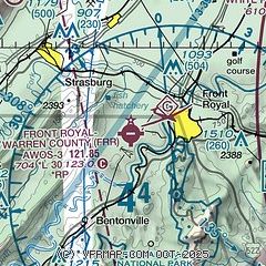
| Sectional chart |
|---|
|
| Airport distance calculator |
|---|
|
|
| Sunrise and sunset |
|---|
|
Times for 03-Apr-2026
| | Local
(UTC-4) | | Zulu
(UTC) |
|---|
| Morning civil twilight | | 06:29 | | 10:29 |
| Sunrise | | 06:56 | | 10:56 |
| Sunset | | 19:37 | | 23:37 |
| Evening civil twilight | | 20:04 | | 00:04 |
|
| Current date and time |
|---|
| Zulu (UTC) | 03-Apr-2026 13:02:56 |
|---|
| Local (UTC-4) | 03-Apr-2026 09:02:56 |
|---|
|
| METAR |
|---|
| KFRR | 031255Z AUTO 00000KT 3SM BR OVC003 12/11 A3025 RMK AO2 T01150110
|
KOKV
14nm N | 031255Z AUTO 15004KT 7SM OVC005 11/10 A3025 RMK AO2
|
KLUA
19nm SW | 031255Z AUTO 00000KT 1/4SM FG OVC002 11/10 A3026 RMK AO2
|
|
| TAF |
|---|
KMRB
32nm NE | 031120Z 0312/0412 VRB03KT 3SM BR OVC004 FM031400 18009KT P6SM SCT030 FM031800 20010G17KT P6SM SCT060 FM032300 19005KT P6SM BKN070 FM040600 21002KT P6SM SCT090 BKN200
|
KIAD
38nm E | 031120Z 0312/0418 15004KT 1SM BR OVC005 FM031400 19008KT P6SM OVC007 FM031600 20012G21KT P6SM SCT030 FM032200 20009KT P6SM SCT070 FM040400 19004KT P6SM SCT120 BKN250
|
|
| NOTAMs |
|---|
NOTAMs are issued by the DoD/FAA and will open in a separate window not controlled by AirNav.
|
|

