FAA INFORMATION EFFECTIVE 09 JULY 2026
Location
| FAA Identifier: | HYA |
| Lat/Long: | 41-40-09.6140N 070-16-49.2930W
41-40.160233N 070-16.821550W
41.6693372,-70.2803592
(estimated) |
| Elevation: | 54.1 ft. / 16.5 m (surveyed) |
| Variation: | 16W (1995) |
| From city: | 1 mile N of HYANNIS, MA |
| Time zone: | UTC -4 (UTC -5 during Standard Time) |
| Zip code: | 02601 |
Airport Operations
| Airport use: | Open to the public |
| Activation date: | 02/1940 |
| Control tower: | yes |
| ARTCC: | BOSTON CENTER |
| FSS: | BRIDGEPORT FLIGHT SERVICE STATION |
| NOTAMs facility: | HYA (NOTAM-D service available) |
| Attendance: | CONTINUOUS
AVGAS UNAVBL BTN 1900 & 0600 LCL DLY. CALL GRIFFIN AFT HRS 508-367-2140. |
| Wind indicator: | lighted |
| Segmented circle: | yes |
| Lights: | ACTVT MALSR RWY 15; MALSF RWY 24; HIRL RWYS 06/24 & 15/33 - CTAF. |
| Beacon: | white-green (lighted land airport)
Operates sunset to sunrise. |
| Landing fee: | no, LDG FEE FOR ALL ACFT OVER 6000 LBS. |
| Fire and rescue: | ARFF index A |
| Airline operations: | CLSD TO UNSKED ACR OPS WITH MORE THAN 9 PAX SEATS 0000-0600 EXCP 1 HR PPR AMGR 508-778-7770. |
| International operations: | customs landing rights airport |
Airport Communications
| CTAF: | 119.5 |
| UNICOM: | 122.95 |
| ATIS: | 123.8 |
| WX ASOS: | PHONE 508-862-2601 |
| HYANNIS GROUND: | 118.45 [0600-2200] |
| HYANNIS TOWER: | 119.5 257.8 [0600-2200] |
| BOSTON APPROACH: | 118.2 |
| BOSTON DEPARTURE: | 118.2 |
| CLEARANCE DELIVERY: | 125.15 120.125 ;WHEN TWR CLSD |
| WX ASOS at FMH (11 nm W): | PHONE 508-968-6562 |
| WX ASOS at CQX (13 nm E): | 135.875 (508-945-5034) |
Nearby radio navigation aids
| VOR radial/distance | | VOR name | | Freq | | Var |
|---|
| MVYr057/22.2 | | MARTHAS VINEYARD VOR/DME | | 114.50 | | 15W |
| LFVr224/23.5 | | MARCONI VOR/DME | | 114.70 | | 16W |
| ACKr349/25.9 | | NANTUCKET VOR/DME | | 116.20 | | 15W |
| NDB name | | Hdg/Dist | | Freq | | Var | | ID |
|---|
| NAUSET | | 280/13.2 | | 279 | | 16W | | CQX | -.-. --.- -..- |
| PROVINCETOWN | | 202/24.1 | | 389 | | 16W | | PVC | .--. ...- -.-. |
Airport Services
| Fuel available: | 100LL JET-A |
| Parking: | hangars and tiedowns |
| Airframe service: | MAJOR |
| Powerplant service: | MAJOR |
| Bottled oxygen: | NONE |
| Bulk oxygen: | NONE |
Runway Information
Runway 6/24
| Dimensions: | 5425 x 150 ft. / 1654 x 46 m |
| Surface: | asphalt/grooved, in good condition |
| Weight bearing capacity: | | Single wheel: | 30.0 | | Double wheel: | 108.0 |
|
| Runway edge lights: | high intensity |
| RUNWAY 6 | | RUNWAY 24 |
| Latitude: | 41-39.875790N | | 41-40.452262N |
| Longitude: | 070-16.966562W | | 070-16.056540W |
| Elevation: | 44.4 ft. | | 39.1 ft. |
| Traffic pattern: | left | | left |
| Runway heading: | 066 magnetic, 050 true | | 246 magnetic, 230 true |
| Displaced threshold: | 406 ft. | | no |
| Declared distances: | TORA:5425 TODA:5425 ASDA:5425 LDA:5019 | | TORA:5425 TODA:5425 ASDA:5425 LDA:5425 |
| Markings: | precision, in good condition | | precision, in good condition |
| Visual slope indicator: | 4-light PAPI on left (3.00 degrees glide path) | | 4-light PAPI on left (3.00 degrees glide path) |
| RVR equipment: | rollout | | touchdown |
| Approach lights: | | | MALSF: 1,400 foot medium intensity approach lighting system with sequenced flashers |
| Runway end identifier lights: | yes | | |
| Touchdown point: | yes, no lights | | yes, no lights |
| Instrument approach: | | | ILS/DME |
| Obstructions: | 17 ft. tree, 450 ft. from runway, 300 ft. left of centerline, 14:1 slope to clear
APCH RATIO 50:1 TO DTHR. | | 20 ft. rr, 400 ft. from runway, 300 ft. left of centerline, 10:1 slope to clear |
Runway 15/33
| Dimensions: | 5255 x 150 ft. / 1602 x 46 m |
| Surface: | asphalt/grooved, in good condition |
| Weight bearing capacity: | | Single wheel: | 30.0 | | Double wheel: | 108.0 |
|
| Runway edge lights: | high intensity |
| RUNWAY 15 | | RUNWAY 33 |
| Latitude: | 41-40.486603N | | 41-39.825945N |
| Longitude: | 070-17.514167W | | 070-16.768943W |
| Elevation: | 54.1 ft. | | 42.4 ft. |
| Traffic pattern: | left | | left |
| Runway heading: | 156 magnetic, 140 true | | 336 magnetic, 320 true |
| Displaced threshold: | no | | 150 ft.
APCH RATIO 34:1 TO DTHR. |
| Declared distances: | TORA:5255 TODA:5255 ASDA:5255 LDA:5255 | | TORA:5255 TODA:5255 ASDA:5255 LDA:5105 |
| Markings: | precision, in good condition | | precision, in good condition |
| Visual slope indicator: | | | 4-light PAPI on left (3.00 degrees glide path) |
| RVR equipment: | touchdown | | rollout |
| Approach lights: | MALSR: 1,400 foot medium intensity approach lighting system with runway alignment indicator lights | | |
| Touchdown point: | yes, no lights | | yes, no lights |
| Instrument approach: | ILS/DME | | |
| Obstructions: | 146 ft. pline, lighted, 5175 ft. from runway, 34:1 slope to clear | | none |
Airport Ownership and Management from official FAA records
| Ownership: | Publicly-owned |
| Owner: | TOWN OF BARNSTABLE
TOWN HALL 367 MAIN ST
HYANNIS, MA 02601
Phone 508-862-4600 |
| Manager: | MICHAEL NELSON
480 BARNSTABLE RD
HYANNIS, MA 02601
Phone 508-775-2020 |
Additional Remarks
| A39-06/24 | PCR VALUE: 384/F/A/X/T |
| A39-15/33 | PCR VALUE: 355/F/A/X/T |
| E60-24 | ENGINEERING MTRLS ARST SYS (EMAS) 200 FT IN LEN BY 176 FT WID LCTD AT THE DER 24. |
| - | ANT ON TANK 4600 FT SE ELEV 208 FT; STANDPIPE 7050 FT NORTH 236 FT; OBSTN LGTD. |
| - | TWY B CLSD TO ACFT WITH WINGSPAN GTR THAN 118 FT. TWY B BTN TWY D & RWY 6-24 CLSD TO ACFT WITH WINGSPAN GTR THAN 78 FT. |
| - | BE AWARE OF HIGH-SPD MIL JET & HVY HEL TFC VCNTY JOINT BASE CAPE COD. DO NOT CONFUSE JOINT BASE CAPE COD, 10NM W WITH CAPE COD GATEWAY. |
| - | ARFF INDEX B SVCS PRVDD BTN 0600 AND 2159 LCL DLY. ARFF INDEX A SVCS PRVDD DRG OTR TIMES. FOR INDEX B SVCS BTN 2200 AND 0559 LCL, 1HR 30MIN PPR AT 508-778-7770. |
| - | BIRDS, COYOTES ON & INVOF ARPT. |
| - | ARPT HAS NOISE ABATEMENT CTC AMGR 508-778-7765. |
| - | TGL OPS PROHIBITED BTN 2100-0559, PPR BY AMGR. |
| - | ALL TSNT & GA PILOTS MUST CTC ARPT OPS ON FREQ 122.95 PRIOR TO ENG SHTDN FOR AIRFIELD ESCORT BTN 2200-0559 LCL. |
Instrument Procedures
NOTE: All procedures below are presented as PDF files. If you need a reader for these files, you should download the free Adobe Reader.NOT FOR NAVIGATION. Please procure official charts for flight.
FAA instrument procedures published for use from 09 July 2026 at 0901Z to 06 August 2026 at 0900Z.
IAPs - Instrument Approach Procedures |
|---|
| ILS OR LOC RWY 15 | |
download (361KB) |
| ILS OR LOC RWY 24 | |
download (312KB) |
| RNAV (GPS) RWY 06 | |
download (309KB) |
| RNAV (GPS) RWY 15 | |
download (321KB) |
| RNAV (GPS) RWY 24 **CHANGED** | |
download (293KB) |
| RNAV (GPS) RWY 33 | |
download (282KB) |
| VOR RWY 06 | |
download (269KB) |
| NOTE: Special Alternate Minimums apply | |
download (129KB) |
| NOTE: Special Take-Off Minimums/Departure Procedures apply | |
download (528KB) |
Other nearby airports with instrument procedures:
KFMH - Cape Cod Coast Guard Air Station (11 nm W)
5B6 - Falmouth Airpark (13 nm SW)
KCQX - Chatham Municipal Airport (13 nm E)
KMVY - Martha's Vineyard Airport (22 nm SW)
KPVC - Provincetown Municipal Airport (24 nm N)
|
|

Road maps at:
MapQuest
Bing
Google
| Aerial photo |
|---|
WARNING: Photo may not be current or correct
 Photo courtesy of AirNav, LLC
Photo taken 24-Aug-2012
looking southeast.
Photo courtesy of AirNav, LLC
Photo taken 24-Aug-2012
looking southeast.
Do you have a better or more recent aerial photo of Cape Cod Gateway Airport that you would like to share? If so, please send us your photo.
|
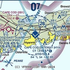
| Sectional chart |
|---|
|
 Download PDF
of official airport diagram from the FAA
| Airport distance calculator |
|---|
|
|
| Sunrise and sunset |
|---|
|
Times for 28-Jul-2026
| | Local
(UTC-4) | | Zulu
(UTC) |
|---|
| Morning civil twilight | | 05:01 | | 09:01 |
| Sunrise | | 05:32 | | 09:32 |
| Sunset | | 20:03 | | 00:03 |
| Evening civil twilight | | 20:34 | | 00:34 |
|
| Current date and time |
|---|
| Zulu (UTC) | 28-Jul-2026 14:06:03 |
|---|
| Local (UTC-4) | 28-Jul-2026 10:06:03 |
|---|
|
| METAR |
|---|
| KHYA | 281356Z 22008KT 10SM BKN010 24/21 A2977 RMK AO2 SLP080 T02390206
|
KFMH
11nm W | 281356Z 22008KT 10SM BKN014 OVC021 25/22 A2978
|
KCQX
13nm E | 281352Z AUTO VRB06KT 10SM OVC007 24/21 A2980 RMK AO2 SLP091 T02390211 $
|
|
| TAF |
|---|
| KHYA | 281127Z 2812/2912 21008KT P6SM OVC005 FM281400 19008KT P6SM SCT060 FM281700 18011G20KT P6SM SCT060 FM282300 16010KT P6SM SCT040 FM290400 14010G18KT P6SM BKN020 FM290800 13012G21KT 3SM BR OVC008
|
KFMH
11nm W | 281127Z 2812/2912 21005KT 6SM BR BKN005 FM281400 19008KT P6SM SCT060 FM281700 18010G20KT P6SM SCT060 FM282300 16009KT P6SM SCT040 FM290400 14007KT P6SM BKN015 FM290900 12010G20KT 3SM BR BKN006
|
|
| NOTAMs |
|---|
NOTAMs are issued by the DoD/FAA and will open in a separate window not controlled by AirNav.
|
|


