FAA INFORMATION EFFECTIVE 16 APRIL 2026
Location
| FAA Identifier: | IDI |
| Lat/Long: | 40-37-51.8190N 079-06-05.4950W
40-37.863650N 079-06.091583W
40.6310608,-79.1015264
(estimated) |
| Elevation: | 1419.3 ft. / 432.6 m (surveyed) |
| Variation: | 10W (2020) |
| From city: | 2 miles E of INDIANA, PA |
| Time zone: | UTC -4 (UTC -5 during Standard Time) |
| Zip code: | 15701 |
Airport Operations
| Airport use: | Open to the public |
| Activation date: | 12/1951 |
| Control tower: | no |
| ARTCC: | CLEVELAND CENTER |
| FSS: | ALTOONA FLIGHT SERVICE STATION |
| NOTAMs facility: | IDI (NOTAM-D service available) |
| Attendance: | MON-FRI 0800-1600
ARPT ATNDNC AFTER HRS BY PRIOR ARNGMT. CLSD MAJOR HOL. |
| Wind indicator: | lighted |
| Segmented circle: | yes |
| Lights: | ACTVT REIL RWY 11; PAPI RWY 11 & 29; HIRL RWY 11/29 & TWYS - CTAF. |
| Beacon: | white-green (lighted land airport)
Operates sunset to sunrise. |
| Landing fee: | yes, LNDG FEE FOR FIXED WING TURBINE ACFT WAIVED WITH FUEL PURCHASE. |
Airport Communications
| CTAF/UNICOM: | 122.8 |
| WX AWOS-3: | 126.625 (724-388-0204) |
| JOHNSTOWN APPROACH: | 121.2 |
| JOHNSTOWN DEPARTURE: | 121.2 |
- APCH/DEP SVC PRVDD BY CLEVELAND ARTCC (ZOB) ON FREQS 124.4/299.2 (ALTOONA RCAG) WHEN JOHNSTOWN APCH CTL CLSD.
Nearby radio navigation aids
| VOR radial/distance | | VOR name | | Freq | | Var |
|---|
| JSTr333/22.5 | | JOHNSTOWN VOR/DME | | 113.00 | | 06W |
Airport Services
| Fuel available: | 100LL JET-A JET-A+
100LL:24 HR 100LL AVBL WITH CREDIT CARD. |
| Parking: | hangars and tiedowns |
| Airframe service: | MINOR |
| Powerplant service: | MINOR |
| Bottled oxygen: | NONE |
| Bulk oxygen: | NONE |
Runway Information
Runway 11/29
| Dimensions: | 5502 x 100 ft. / 1677 x 30 m |
| Surface: | asphalt, in good condition |
| Runway edge lights: | high intensity |
| RUNWAY 11 | | RUNWAY 29 |
| Latitude: | 40-37.913195N | | 40-37.814043N |
| Longitude: | 079-06.682645W | | 079-05.500552W |
| Elevation: | 1367.2 ft. | | 1419.1 ft. |
| Traffic pattern: | left | | left |
| Runway heading: | 106 magnetic, 096 true | | 286 magnetic, 276 true |
| Markings: | nonprecision, in fair condition | | precision, in good condition |
| Visual slope indicator: | 4-light PAPI on left (3.00 degrees glide path) | | 4-light PAPI on left (3.00 degrees glide path) |
| Runway end identifier lights: | yes | | no |
| Touchdown point: | yes, no lights | | yes, no lights |
| Instrument approach: | | | LOC/DME |
| Obstructions: | 83 ft. trees, 1485 ft. from runway, 623 ft. left of centerline, 15:1 slope to clear | | 137 ft. trees, 3158 ft. from runway, 660 ft. left of centerline, 21:1 slope to clear |
Airport Ownership and Management from official FAA records
| Ownership: | Publicly-owned |
| Owner: | COUNTY OF INDIANA
398 AIRPORT ROAD
INDIANA, PA 15701
Phone 724-463-3883 |
| Manager: | RODGER EWING
398 AIRPORT ROAD
INDIANA, PA 15701
Phone 724-463-3883 |
Additional Remarks
| - | BIRDS & DEER ON & INVOF ARPT. |
| - | FOR CD CTC JOHNSTOWN APCH AT 814-532-5960, WHEN APCH CLSD CTC CLEVELAND ARTCC AT 440-774-0213. |
Instrument Procedures
NOTE: All procedures below are presented as PDF files. If you need a reader for these files, you should download the free Adobe Reader.NOT FOR NAVIGATION. Please procure official charts for flight.
FAA instrument procedures published for use from 16 April 2026 at 0901Z to 14 May 2026 at 0900Z.
IAPs - Instrument Approach Procedures |
|---|
| RNAV (GPS) RWY 11 | |
download (265KB) |
| RNAV (GPS) RWY 29 | |
download (271KB) |
| NOTE: Special Alternate Minimums apply | |
download (122KB) |
| NOTE: Special Take-Off Minimums/Departure Procedures apply **CHANGED** | |
download (435KB) |
Other nearby airports with instrument procedures:
9G8 - Ebensburg Airport (18 nm SE)
N35 - Punxsutawney Municipal Airport (22 nm N)
KJST - John Murtha Johnstown/Cambria County Airport (23 nm SE)
6P7 - McVille Airport (23 nm W)
KLBE - Arnold Palmer Regional Airport (26 nm SW)
|
|

Road maps at:
MapQuest
Bing
Google
| Aerial photo |
|---|
WARNING: Photo may not be current or correct
 Photo by Tip Ruffner
Taken in the Summer of 2017
looking east.
Photo by Tip Ruffner
Taken in the Summer of 2017
looking east.
Do you have a better or more recent aerial photo of Indiana County Airport (Jimmy Stewart Field) that you would like to share? If so, please send us your photo.
|
| Sectional chart |
|---|
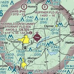
|
| Airport distance calculator |
|---|
|
|
| Sunrise and sunset |
|---|
|
Times for 25-Apr-2026
| | Local
(UTC-4) | | Zulu
(UTC) |
|---|
| Morning civil twilight | | 05:55 | | 09:55 |
| Sunrise | | 06:24 | | 10:24 |
| Sunset | | 20:05 | | 00:05 |
| Evening civil twilight | | 20:34 | | 00:34 |
|
| Current date and time |
|---|
| Zulu (UTC) | 25-Apr-2026 21:53:04 |
|---|
| Local (UTC-4) | 25-Apr-2026 17:53:04 |
|---|
|
| METAR |
|---|
| KIDI | 252135Z AUTO 29009KT 10SM OVC009 13/12 A2983 RMK A01
|
|
| TAF |
|---|
KJST
22nm SE | 251730Z 2518/2618 17009KT 4SM -RA BR OVC007 FM252000 18008KT 2SM -RA BR OVC004 FM252300 30006KT 2SM -RA BR OVC003 FM260200 31006KT 1/2SM -DZ FG VV003 FM261400 07006KT 1 1/2SM BR OVC003 FM261500 07006KT P6SM OVC007
|
KLBE
26nm SW | 251720Z 2518/2618 22008KT 6SM -SHRA BKN015 TEMPO 2518/2520 BKN007 FM252000 33008KT P6SM BKN007 TEMPO 2521/2524 BKN015 FM260700 00000KT 2SM BR BKN004 FM261100 00000KT P6SM BKN008 FM261400 03004KT P6SM BKN015
|
|
| NOTAMs |
|---|
NOTAMs are issued by the DoD/FAA and will open in a separate window not controlled by AirNav.
|
|

