FAA INFORMATION EFFECTIVE 27 NOVEMBER 2025
Location
| FAA Identifier: | IKG |
| Lat/Long: | 27-33-03.1000N 098-01-51.3000W
27-33.051667N 098-01.855000W
27.5508611,-98.0309167
(estimated) |
| Elevation: | 130.1 ft. / 39.7 m (surveyed) |
| Variation: | 06E (2000) |
| From city: | 9 miles W of KINGSVILLE, TX |
| Time zone: | UTC -6 (UTC -5 during Daylight Saving Time) |
| Zip code: | 78363 |
Airport Operations
| Airport use: | Open to the public |
| Activation date: | 02/1964 |
| Control tower: | no |
| ARTCC: | HOUSTON CENTER |
| FSS: | SAN ANGELO FLIGHT SERVICE STATION |
| NOTAMs facility: | SJT (NOTAM-D service available) |
| Attendance: | MON-FRI 0800-1630, ALL SAT-SUN 0800-1500 |
| Wind indicator: | lighted |
| Segmented circle: | yes |
| Lights: | MIRL RWY 13/31 PRESET LOW INTST; TO INCR INTST & ACTVT REIL RWYS 13 & 31 - CTAF. |
| Beacon: | white-green (lighted land airport)
Operates sunset to sunrise. |
| Landing fee: | yes, LDG FEE FOR TURBINE & JET ACFT. FEE WAIVED WITH MNM FUEL PURCHASE. |
Airport Communications
| CTAF/UNICOM: | 122.7 |
| WX AWOS-3P: | 119.075 (361-592-9152) |
| KINGSVILLE APPROACH: | 119.9 [1345-0600Z++ MON-THU; 1345-2345Z++ FRI; CLSD SAT, SUN AND HOL EXC BY NOTAM, HRS SUBJ TO CHG.] |
| KINGSVILLE DEPARTURE: | 119.9 [1345-0600Z++ MON-THU; 1345-2345Z++ FRI; CLSD SAT, SUN AND HOL EXC BY NOTAM, HRS SUBJ TO CHG.] |
| WX ASOS at ALI (11 nm N): | 119.225 (361-668-0069) |
- APCH/DEP SVC PRVDD BY HOUSTON ARTCC (ZHU) ON FREQS 128.15/350.3 (SARITA RCAG) WHEN KINGSVILLE APCH CLSD.
Nearby radio navigation aids
| VOR radial/distance | | VOR name | | Freq | | Var |
|---|
| ALIr177/(11.3) | | ALICE VOR | | 114.50 | | 06E |
| CRPr227/37.6 | | CORPUS CHRISTI VORTAC | | 115.50 | | 09E |
Airport Services
| Fuel available: | 100LL JET-A |
| Parking: | hangars and tiedowns |
| Airframe service: | MAJOR |
| Powerplant service: | MAJOR |
| Bottled oxygen: | HIGH |
| Bulk oxygen: | NONE |
Runway Information
Runway 13/31
| Dimensions: | 6000 x 75 ft. / 1829 x 23 m |
| Surface: | asphalt, in good condition |
| Weight bearing capacity: | | Single wheel: | 35.0 | | Double wheel: | 47.0 | | Double tandem: | 70.0 |
|
| Runway edge lights: | medium intensity |
| Runway edge markings: | RWY MKGS FADED/DISCOLORED. |
| RUNWAY 13 | | RUNWAY 31 |
| Latitude: | 27-33.430702N | | 27-32.672010N |
| Longitude: | 098-02.212448W | | 098-01.498620W |
| Elevation: | 130.1 ft. | | 124.5 ft. |
| Traffic pattern: | left | | left |
| Runway heading: | 134 magnetic, 140 true | | 314 magnetic, 320 true |
| Markings: | nonprecision, in poor condition | | nonprecision, in poor condition |
| Visual slope indicator: | 4-light PAPI on left (3.00 degrees glide path) | | 4-light PAPI on left (3.00 degrees glide path) |
| Runway end identifier lights: | yes | | yes |
| Touchdown point: | yes, no lights | | yes, no lights |
| Obstructions: | 20 ft. trees, 201 ft. from runway, 270 ft. left of centerline
20 FT TREES 0-199 FT FM THR 270 FT L. | | 26 ft. tree, 1400 ft. from runway, 540 ft. left of centerline, 46:1 slope to clear |
Airport Ownership and Management from official FAA records
| Ownership: | Publicly-owned |
| Owner: | KLEBERG COUNTY
PO BOX 752
KINGSVILLE, TX 78364
Phone 361-595-8585
JUDGE RUDY MADRID, KLEBERG CO. |
| Manager: | MIKE MUZYCZYN, FBO
PO BOX 53
KINGSVILLE, TX 78364
Phone 361-592-1225 |
Additional Remarks
| A105 | MOST MIL OPNS LOW APCHS FM KINGSVILLE NAS & CORPUS CHRISTI NAS. |
| - | BIRDS ON & INVOF ARPT. |
| - | FOR CD CTC HOUSTON ARTCC AT 281-230-5622. |
Instrument Procedures
NOTE: All procedures below are presented as PDF files. If you need a reader for these files, you should download the free Adobe Reader.NOT FOR NAVIGATION. Please procure official charts for flight.
FAA instrument procedures published for use from 27 November 2025 at 0901Z to 25 December 2025 at 0900Z.
IAPs - Instrument Approach Procedures |
|---|
| RNAV (GPS) RWY 13 | |
download (235KB) |
| NOTE: Special Take-Off Minimums/Departure Procedures apply | |
download (105KB) |
Other nearby airports with instrument procedures:
KALI - Alice International Airport (11 nm N)
KNQI - Kingsville Naval Air Station (12 nm E)
KNOG - Orange Grove Naval Auxiliary Field (21 nm N)
KBKS - Brooks County Airport (21 nm S)
KRBO - Nueces County Airport (23 nm NE)
|
|

Road maps at:
MapQuest
Bing
Google
| Aerial photo |
|---|
WARNING: Photo may not be current or correct
 looking east
Do you have a better or more recent aerial photo of Kleberg County Airport that you would like to share? If so, please send us your photo.
|
| Sectional chart |
|---|
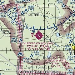
|
| Airport distance calculator |
|---|
|
|
| Sunrise and sunset |
|---|
|
Times for 15-Dec-2025
| | Local
(UTC-6) | | Zulu
(UTC) |
|---|
| Morning civil twilight | | 06:50 | | 12:50 |
| Sunrise | | 07:16 | | 13:16 |
| Sunset | | 17:39 | | 23:39 |
| Evening civil twilight | | 18:04 | | 00:04 |
|
| Current date and time |
|---|
| Zulu (UTC) | 15-Dec-2025 15:22:47 |
|---|
| Local (UTC-6) | 15-Dec-2025 09:22:47 |
|---|
|
| METAR |
|---|
KALI
11nm N | 151453Z AUTO 02010KT 10SM CLR 06/M01 A3050 RMK AO2 SLP327 T00561011 53005
|
KNQI
12nm E | 151456Z 02009KT 10SM OVC018 06/M01 A3050 RMK AO2 SLP325 T00561006 51005 $
|
|
| TAF |
|---|
KALI
11nm N | 151123Z 1512/1612 01006KT P6SM SCT025 BKN250 TEMPO 1512/1516 BKN022 FM151700 VRB05KT P6SM SCT070 BKN250 FM160900 VRB03KT P6SM BKN035
|
KNQI
12nm E | 1513/1607 02010KT 9999 SCT015 BKN050 BKN250 QNH3028INS TEMPO 1513/1515 OVC015 FM152100 10007KT 9999 SCT050 BKN250 QNH3024INS FM160200 VRB04KT 9999 SCT015 BKN025 OVC250 QNH3018INS TX15/1521Z TN04/1513Z AMD 1305 FN20081
|
|
| NOTAMs |
|---|
NOTAMs are issued by the DoD/FAA and will open in a separate window not controlled by AirNav.
|
|

