FAA INFORMATION EFFECTIVE 22 JANUARY 2026
Location
| FAA Identifier: | NOG |
| Lat/Long: | 27-53-48.5454N 098-02-36.8049W
27-53.809090N 098-02.613415W
27.8968182,-98.0435569
(estimated) |
| Elevation: | 257.2 ft. / 78.4 m (surveyed) |
| Variation: | 05E (2010) |
| From city: | 8 miles N of ORANGE GROVE, TX |
| Time zone: | UTC -6 (UTC -5 during Daylight Saving Time) |
| Zip code: | 78372 |
Airport Operations
| Airport use: | Private use. Permission required prior to landing |
| Control tower: | yes |
| ARTCC: | HOUSTON CENTER |
| FSS: | SAN ANGELO FLIGHT SERVICE STATION |
| NOTAMs facility: | SJT (NOTAM-D service available) |
| Attendance: | ALL
OPR HRS BY NOTAM IN SUPPORT OF TRAWING-2 FLT OPR. |
| Segmented circle: | no |
| Lights: | AVBL ONLY DURING HRS OF OPERATION. |
| Beacon: | white-white-green (lighted military airport)
Operates sunset to sunrise. |
Airport Communications
| ATIS: | 254.35 |
| NAVY ORANGE GROUND: | 229.4 [1330-2130Z++ MON-FRI; CLSD SAT, SUN AND HOL BY NOTAM; HRS SUBJECT TO CHG IN SUPPORT OF TRAWING-2 FLT OPR.] |
| NAVY ORANGE TOWER: | 128.4 318.85 281.425 [1330-2130Z++ MON-FRI; CLSD SAT, SUN AND HOL BY NOTAM; HRS SUBJECT TO CHG IN SUPPORT OF TRAWING-2 FLT OPR.] |
| KINGSVILLE APPROACH: | 119.9 |
| KINGSVILLE DEPARTURE: | 119.9 |
| CLEARANCE DELIVERY: | 229.4 |
| WX ASOS at ALI (9 nm S): | 119.225 (361-668-0069) |
- APCH/DEP SVC PRVDD BY HOUSTON ARTCC (ZHU) ON FREQS 128.15/350.3 (SARITA RCAG) WHEN KINGSVILLE APCH CLSD.
- FREQ 318.85 LDG SIGNAL OFFICER
Nearby radio navigation aids
| VOR radial/distance | | VOR name | | Freq | | Var |
|---|
| ALIr347/(9.5) | | ALICE VOR | | 114.50 | | 06E |
| CRPr260/31.7 | | CORPUS CHRISTI VORTAC | | 115.50 | | 09E |
Airport Services
| Bottled oxygen: | NONE |
| Bulk oxygen: | NONE |
Runway Information
Runway 13/31
| Dimensions: | 8001 x 198 ft. / 2439 x 60 m |
| Surface: | PEM, in fair condition |
| Weight bearing capacity: | |
| Runway edge lights: | medium intensity |
| RUNWAY 13 | | RUNWAY 31 |
| Latitude: | 27-54.350958N | | 27-53.423463N |
| Longitude: | 098-03.019532W | | 098-01.961717W |
| Elevation: | 257.2 ft. | | 224.3 ft. |
| Traffic pattern: | left | | left |
| Runway heading: | 130 magnetic, 135 true | | 310 magnetic, 315 true |
| Markings: | precision, in fair condition | | precision, in fair condition |
| Touchdown point: | yes, no lights | | yes, no lights |
| Instrument approach: | ILS/DME | | |
Runway 1/19
| Dimensions: | 8000 x 198 ft. / 2438 x 60 m |
| Surface: | PEM, in fair condition |
| Weight bearing capacity: | |
| Runway edge lights: | medium intensity |
| RUNWAY 1 | | RUNWAY 19 |
| Latitude: | 27-53.092020N | | 27-54.370020N |
| Longitude: | 098-02.923610W | | 098-02.548368W |
| Elevation: | 229.6 ft. | | 240.8 ft. |
| Traffic pattern: | left | | left |
| Runway heading: | 010 magnetic, 015 true | | 190 magnetic, 195 true |
| Markings: | precision, in fair condition | | precision, in fair condition |
| Touchdown point: | yes, no lights | | yes, no lights |
Airport Ownership and Management from official FAA records
| Ownership: | U.S. Navy |
| Owner: | US NAVY
OCEANOGRAPHIC OFC - CODE 3142
WASHINGTON, DC 20373 |
Additional Remarks
| E60-01 | HOOK E28(B) (1500'). |
| E60-19 | HOOK E28(B) (1500'). |
| E60-13 | HOOK E28(B) (1500'). |
| E60-31 | HOOK E28(B) (1501'). |
| - | CAUTION: STUDENT JET TRNG IN VCNTY DUR OPR HR. |
| - | RWY-LGTS: RWY 01 - OLS. RWY 19 - OLS. |
| - | RWY-LGTS: RWY 13 - OLS. RWY 31 - OLS. |
| - | SERVICE-LGT: OLS GS 3.25DEG. |
| - | CAUTION: BIRD AND LARGE WILDLIFE HAZARD. |
| - | JET BREAK ALT 1300 FT MSL. USE LDG/TAXI LGT ON FINAL APCH DUR VFR COND. |
| - | RSTD: CNATRA USE ONLY EXC IN EMERG, NALF ADMIN DSN 876-6140, NAS KINGSVILLE BASE OPS DSN 876-6108. |
| - | TRAN ALERT: NO TRAN MAINT OR SVC AVBL. REFUEL CNATRA ACFT ONLY. |
| - | BEARING STRENGTH RWY 13/31: ST119 SBTT320 TRT306. |
| - | FUEL: JAA. |
| - | FLUID: SP PRESAIR. |
| - | OIL: O-156. |
Instrument Procedures
NOTE: All procedures below are presented as PDF files. If you need a reader for these files, you should download the free Adobe Reader.NOT FOR NAVIGATION. Please procure official charts for flight.
FAA instrument procedures published for use from 22 January 2026 at 0901Z to 19 February 2026 at 0900z.
IAPs - Instrument Approach Procedures |
|---|
| HI-ILS W OR LOC W RWY 13 | |
download (144KB) |
| HI-ILS Y OR LOC Y RWY 13 | |
download (145KB) |
| ILS X OR LOC X RWY 13 | |
download (116KB) |
| ILS Z OR LOC Z RWY 13 | |
download (117KB) |
| HI-TACAN Y RWY 13 | |
download (132KB) |
| TACAN RWY 31 | |
download (102KB) |
| TACAN Z RWY 13 | |
download (102KB) |
| TACAN-A | |
download (97KB) |
| NOTE: Special Take-Off Minimums/Departure Procedures apply | |
download (293KB) |
Other nearby airports with instrument procedures:
KALI - Alice International Airport (9 nm S)
KRBO - Nueces County Airport (20 nm E)
KIKG - Kleberg County Airport (21 nm S)
KNQI - Kingsville Naval Air Station (27 nm SE)
T69 - Sinton Airport (28 nm E)
|
|

Road maps at:
MapQuest
Bing
Google
| Aerial photo |
|---|
WARNING: Photo may not be current or correct

Do you have a better or more recent aerial photo of Orange Grove Naval Auxiliary Field that you would like to share? If so, please send us your photo.
|
| Sectional chart |
|---|
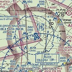
|
 Download PDF
of official airport diagram from the FAA
| Airport distance calculator |
|---|
|
|
| Sunrise and sunset |
|---|
|
Times for 01-Feb-2026
| | Local
(UTC-6) | | Zulu
(UTC) |
|---|
| Morning civil twilight | | 06:56 | | 12:56 |
| Sunrise | | 07:20 | | 13:20 |
| Sunset | | 18:12 | | 00:12 |
| Evening civil twilight | | 18:36 | | 00:36 |
|
| Current date and time |
|---|
| Zulu (UTC) | 01-Feb-2026 10:39:30 |
|---|
| Local (UTC-6) | 01-Feb-2026 04:39:30 |
|---|
|
| METAR |
|---|
| KNOG | 010956Z AUTO 32007KT CLR M01/M08 A3047 RMK AO2 SLP298 T10061078 PNO $
|
|
| TAF |
|---|
KALI
10nm S | 010520Z 0106/0206 VRB06KT P6SM SKC AMD NOT SKED
|
|
| NOTAMs |
|---|
NOTAMs are issued by the DoD/FAA and will open in a separate window not controlled by AirNav.
|
|


