FAA INFORMATION EFFECTIVE 14 MAY 2026
Location
| FAA Identifier: | LAA |
| Lat/Long: | 38-04-10.9340N 102-41-18.5790W
38-04.182233N 102-41.309650W
38.0697039,-102.6884942
(estimated) |
| Elevation: | 3705.3 ft. / 1129.4 m (surveyed) |
| Variation: | 07E (2020) |
| From city: | 3 miles SW of LAMAR, CO |
| Time zone: | UTC -6 (UTC -7 during Standard Time) |
| Zip code: | 81052 |
Airport Operations
| Airport use: | Open to the public |
| Activation date: | 11/1941 |
| Control tower: | no |
| ARTCC: | DENVER CENTER |
| FSS: | DENVER FLIGHT SERVICE STATION |
| NOTAMs facility: | LAA (NOTAM-D service available) |
| Attendance: | 0800-1700
FOR SVC AFT HRS PHONE 719-336-7701. |
| Wind indicator: | lighted |
| Segmented circle: | yes |
| Lights: | ACTVT & INCR INTST REIL RWY 08 & 26, RWY 18 & 36; PAPI RWY 08 & 26, RWY 36; VASI RWY 18; MIRL RWY 08/26, 18/36; TWY LGTS - CTAF. ALL LGTS PRESET MED INTST. |
| Beacon: | white-green (lighted land airport)
Operates sunset to sunrise. |
Airport Communications
| CTAF/UNICOM: | 122.8 |
| WX ASOS: | 135.625 ((719) 931-8759) |
- APCH/DEP CTL SVC PRVDD BY DENVER ARTCC (ZDV) ON FREQS 133.4/377.175 (LA JUNTA RCAG).
Nearby radio navigation aids
| VOR radial/distance | | VOR name | | Freq | | Var |
|---|
| LAAr168/7.6 | | LAMAR VOR/DME | | 116.90 | | 12E |
Airport Services
| Fuel available: | 100LL JET-A
100LL:100LL AVBL H24 SELF SVC. |
| Parking: | hangars and tiedowns |
| Airframe service: | MAJOR |
| Powerplant service: | MAJOR |
| Bottled oxygen: | LOW |
| Bulk oxygen: | LOW |
Runway Information
Runway 18/36
| Dimensions: | 6304 x 100 ft. / 1921 x 30 m |
| Surface: | concrete/grooved, in good condition |
| Weight bearing capacity: | | PCN 12 /R/B/W/U | | Single wheel: | 45.0 | | Double wheel: | 55.0 | | Double tandem: | 100.0 |
|
| Runway edge lights: | medium intensity |
| RUNWAY 18 | | RUNWAY 36 |
| Latitude: | 38-04.491468N | | 38-03.467595N |
| Longitude: | 102-41.373295W | | 102-41.592790W |
| Elevation: | 3678.6 ft. | | 3705.3 ft. |
| Traffic pattern: | left | | left |
| Runway heading: | 183 magnetic, 190 true | | 003 magnetic, 010 true |
| Markings: | nonprecision, in good condition | | nonprecision, in good condition |
| Visual slope indicator: | 4-box VASI on left (3.00 degrees glide path) | | 4-light PAPI on left (3.00 degrees glide path) |
| Runway end identifier lights: | yes | | yes |
| Touchdown point: | yes, no lights | | yes, no lights |
| Obstructions: | 30 ft. road, 672 ft. from runway, 15:1 slope to clear | | 28 ft. hill, 946 ft. from runway, 210 ft. right of centerline, 26:1 slope to clear |
Runway 8/26
| Dimensions: | 5001 x 60 ft. / 1524 x 18 m |
| Surface: | asphalt/aggregate friction seal coat, in fair condition |
| Weight bearing capacity: | | Single wheel: | 35.0 | | Double wheel: | 50.0 | | Double tandem: | 95.0 |
|
| Runway edge lights: | medium intensity |
| RUNWAY 8 | | RUNWAY 26 |
| Latitude: | 38-04.435123N | | 38-04.440332N |
| Longitude: | 102-41.612137W | | 102-40.569983W |
| Elevation: | 3682.8 ft. | | 3689.0 ft. |
| Traffic pattern: | left | | left |
| Runway heading: | 083 magnetic, 090 true | | 263 magnetic, 270 true |
| Markings: | basic, in good condition | | basic, in good condition |
| Visual slope indicator: | 2-light PAPI on left (3.00 degrees glide path) | | 2-light PAPI on left (3.00 degrees glide path) |
| Runway end identifier lights: | yes | | yes |
| Touchdown point: | yes, no lights | | yes, no lights |
| Obstructions: | 25 ft. road, 599 ft. from runway, 15:1 slope to clear | | none |
Airport Ownership and Management from official FAA records
| Ownership: | Publicly-owned |
| Owner: | CITY OF LAMAR
102 EAST PARMENTER
LAMAR, CO 81052
Phone 719-336-4376 |
| Manager: | PATRICK MASON
102 E PARMENTER
LAMAR, CO 81052
Phone 719-336-2002 |
Additional Remarks
| - | TOWER 500 FT AGL 4.5 MI SE UNLIGHTED. |
| - | BE ALERT; INTENSIVE USAF STUDENT TRAINING IN VICINITY OF COLORADO SPRINGS & PUEBLO COLORADO. |
| - | FOR CD CTC DENVER ARTCC AT 303-651-4257. |
Instrument Procedures
NOTE: All procedures below are presented as PDF files. If you need a reader for these files, you should download the free Adobe Reader.NOT FOR NAVIGATION. Please procure official charts for flight.
FAA instrument procedures published for use from 14 May 2026 at 0901Z to 11 June 2026 at 0900Z.
IAPs - Instrument Approach Procedures |
|---|
| RNAV (GPS) RWY 08 | |
download (236KB) |
| RNAV (GPS) RWY 18 | |
download (211KB) |
| RNAV (GPS) RWY 26 | |
download (195KB) |
| RNAV (GPS) RWY 36 | |
download (233KB) |
| VOR RWY 18 | |
download (223KB) |
| VOR RWY 36 | |
download (205KB) |
| NOTE: Special Alternate Minimums apply | |
download (156KB) |
| NOTE: Special Take-Off Minimums/Departure Procedures apply | |
download (293KB) |
Other nearby airports with instrument procedures:
8V7 - Springfield Municipal Airport (37 nm S)
KLHX - La Junta Municipal Airport (39 nm W)
3K3 - Syracuse-Hamilton County Municipal Airport (45 nm E)
5K2 - Tribune Municipal Airport (50 nm NE)
KJHN - Stanton County Municipal Airport (54 nm SE)
|
|

Road maps at:
MapQuest
Bing
Google
| Aerial photo |
|---|
WARNING: Photo may not be current or correct
 Photo by Shane Wollert
Photo taken 27-Nov-2014
looking south.
Photo by Shane Wollert
Photo taken 27-Nov-2014
looking south.
Do you have a better or more recent aerial photo of Southeast Colorado Regional Airport that you would like to share? If so, please send us your photo.
|
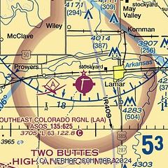
| Sectional chart |
|---|
|
CAUTION: Diagram may not be current

| Airport distance calculator |
|---|
|
|
| Sunrise and sunset |
|---|
|
Times for 01-Jun-2026
| | Local
(UTC-6) | | Zulu
(UTC) |
|---|
| Morning civil twilight | | 05:00 | | 11:00 |
| Sunrise | | 05:31 | | 11:31 |
| Sunset | | 20:07 | | 02:07 |
| Evening civil twilight | | 20:37 | | 02:37 |
|
| Current date and time |
|---|
| Zulu (UTC) | 01-Jun-2026 07:59:12 |
|---|
| Local (UTC-6) | 01-Jun-2026 01:59:12 |
|---|
|
| METAR |
|---|
| KLAA | 010753Z AUTO 12005KT 10SM CLR 15/11 A3001 RMK AO2 SLP117 T01500106 $
|
|
| NOTAMs |
|---|
NOTAMs are issued by the DoD/FAA and will open in a separate window not controlled by AirNav.
|
|


